Chinchey
Chinchey,[1][2][3][4][5] also known as Rurichinchay,[6] is a 6,309-metre-high (20,699 ft)[5] mountain in the Cordillera Blanca in the Andes of Peru. It is located in the region of Ancash, most precisely between the districts of Aco (in Carhuaz Province), Independencia (in Huaraz Province), and Huari (in Huari Province).
| Chinchey | |
|---|---|
| Rurichinchay | |
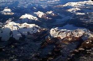 Aerial view of the Cordillera Blanca as seen from the southeast showing Ranrapalca and Chinchey in the left part of the image | |
| Highest point | |
| Elevation | 6,309 m (20,699 ft) |
| Listing | List of mountains in the Andes |
| Coordinates | 9°22′57″S 77°19′47″W |
| Geography | |
 Chinchey Peru | |
| Location | Ancash, Peru |
| Parent range | Cordillera Blanca |
Rurichinchay is also the name of the lake northeast of the mountain at 9°20′31″S 77°19′04″W and the name of the river which originates at the lake. It flows to the southeast.
See also
References
- Ricker, John (1977). Yuraq Janka: A Guide to the Peruvian Andes. The Mountaineers Books. p. 96.
- "Chinchey". www.montanasperuanas.com. Retrieved 2016-05-07.
- Biggar, John (2020). The Andes: A Guide for Climbers and Skiers. Andes. p. 100. ISBN 978-0-9536087-6-8.
- "Nevado Chinchey - Peakbagger.com". peakbagger.com. Retrieved 2016-05-07.
- Alpenvereinskarte 0/3b. Cordillera Blanca Süd (Peru). 1:100 000. Oesterreichischer Alpenverein. 2005. ISBN 3-937530-05-3.
- Peru 1:100 000, Huari (19-i). IGN (Instituto Geográfico Nacional - Perú).
This article is issued from Wikipedia. The text is licensed under Creative Commons - Attribution - Sharealike. Additional terms may apply for the media files.