Tullahan River
The Tullahan River is a river of the Philippines. It is located to the north of Manila and has an approximate length of 7.6 miles (12.2 km). It starts at the La Mesa Reservoir in Quezon City and flows through Malabon and Valenzuela and empties into the Manila Bay.[1]In 2019, San Miguel Corporation pledges ₱1 billion for the cleanup of the Tullahan River as part of the Manila Bay rehabilitation effort.[2]
| Tullahan River | |
|---|---|
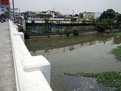 Tullahan Bridge (Potrero, Malabon-Marulas, Valenzuela) | |
.svg.png) .svg.png) | |
| Location | |
| Country | Philippines |
| Region | National Capital Region |
| Cities | |
| Physical characteristics | |
| Source | La Mesa Dam |
| • location | Quezon City |
| Mouth | Manila Bay |
• location | Navotas |
• coordinates | 14°39′00″N 120°56′53″E |
| Basin features | |
| Tributaries | |
| • left | Dampalit River, Polo River |
Bridges
Malabon
- C-4 Bridge I
- Malabon Bridge
- Governor Pascual Bridge
- Tinajeros Bridge
- Harbor Link Bridge - It includes the rail bridge of PNR.
Valenzuela-Malabon
- Tullahan-MacArthur Highway Bridge
Valenzuela-Caloocan (South)
- North Luzon Expressway (NLEX)-Tullahan Bridge
- Tullahan-Ugong Bridge
- Doña Candida Bridge
Valenzuela-Quezon City
- Maceda Bridge
- Mindanao Avenue Bridge
Quezon City
- Katipunan Bridge
- San Dionisio Bridge
- Gozum Bridge
- Tullahan-Quirino Highway Bridge
- Forest Hill Bridge
- Bagong Tulay Bridge
- Accountant Street Bridge
- Tullahan-Commonwealth Bridge - It includes the future rail bridge of MRT 7.
See also
- List of rivers and esteros in Manila
| Wikimedia Commons has media related to Tullahan River. |
References
- The Environment Report Archived 2007-10-11 at the Wayback Machine
- "SMC pledges P1-B for Tullahan River cleanup". Philippine News Agency. Retrieved May 25, 2019.
External links
This article is issued from Wikipedia. The text is licensed under Creative Commons - Attribution - Sharealike. Additional terms may apply for the media files.