Tualatai County
Tualatai County is a county in the Western District in American Samoa.[1][2][3]
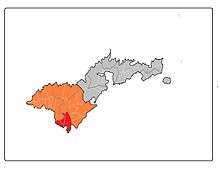
Map of Tutuila where Tualatai County is highlighted in red, while the Western District is marked in orange.
Vailoa and its hamlets Tuautu, Taputimu and Malaeloa are located in Tualatai County. In-between Tualauta and Tualatai counties is the small village of Salaga, which consists of To'agama'a, Fagatele and Fagalua.[4]
Demographics
| Historical population | ||
|---|---|---|
| Year | Pop. | ±% |
| 1912 | 290 | — |
| 1920 | 333 | +14.8% |
| 1930 | 437 | +31.2% |
| 1940 | 527 | +20.6% |
| 1950 | 844 | +60.2% |
| 1960 | 1,008 | +19.4% |
| 1970 | 1,565 | +55.3% |
| 1980 | 2,171 | +38.7% |
| 1990 | 2,568 | +18.3% |
| 2000 | 2,987 | +16.3% |
| 2010 | 3,561 | +19.2% |
| U.S. Decennial Census[5] | ||
Tualatai County was first recorded beginning with the 1912 special census. Regular decennial censuses were taken beginning in 1920.[6]
Villages
- Futiga
- Ituau
- Taputimu
- Vailoata
References
- "CPH-T-8. Population, Housing Units, Land Area, and Density for U.S. Island Areas: 2010" (PDF). United States Census. Retrieved 4 February 2019.
- 1987 Census of Agriculture: Geographic area series, Parts 55-56. Bureau of the Census. p. 4.
- "5.0102 Division of districts into counties". www.asbar.org.
- Krämer, Augustin (2000). The Samoa Islands. University of Hawaii Press. Page 448. ISBN 9780824822194.
- "U.S. Decennial Census". Census.gov. Retrieved June 6, 2013.
- https://www2.census.gov/prod2/decennial/documents/41084484v3ch10.pdf
This article is issued from Wikipedia. The text is licensed under Creative Commons - Attribution - Sharealike. Additional terms may apply for the media files.