Trenton, North Carolina
Trenton is a town in Jones County, North Carolina, United States. The population was 287 in 2010. It is the county seat of Jones County.[4]
Trenton, North Carolina | |
|---|---|
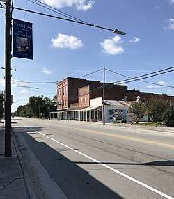 Downtown Trenton | |
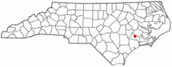 Location of Trenton, North Carolina | |
| Coordinates: 35°3′49″N 77°21′22″W | |
| Country | United States |
| State | North Carolina |
| County | Jones |
| Area | |
| • Total | 0.2 sq mi (0.5 km2) |
| • Land | 0.2 sq mi (0.5 km2) |
| • Water | 0.0 sq mi (0.0 km2) |
| Elevation | 13 ft (4 m) |
| Population (2010) | |
| • Total | 287 |
| • Estimate (2016)[1] | 284 |
| • Density | 1,400/sq mi (570/km2) |
| Time zone | UTC-5 (Eastern (EST)) |
| • Summer (DST) | UTC-4 (EDT) |
| ZIP code | 28585 |
| Area code(s) | 252 |
| FIPS code | 37-68320[2] |
| GNIS feature ID | 0996219[3] |
Trenton is part of the New Bern, North Carolina Micropolitan Statistical Area.
History
Grace Episcopal Church and the Trenton Historic District are listed on the National Register of Historic Places.[5]
Geography
Trenton is located at 35°3′49″N 77°21′22″W (35.063668, -77.356070).[6]
According to the United States Census Bureau, the town has a total area of 0.2 square miles (0.52 km2), all of it land.
Demographics
| Historical population | |||
|---|---|---|---|
| Census | Pop. | %± | |
| 1810 | 98 | — | |
| 1880 | 149 | — | |
| 1890 | 207 | 38.9% | |
| 1900 | 338 | 63.3% | |
| 1910 | 331 | −2.1% | |
| 1920 | 488 | 47.4% | |
| 1930 | 500 | 2.5% | |
| 1940 | 431 | −13.8% | |
| 1950 | 469 | 8.8% | |
| 1960 | 404 | −13.9% | |
| 1970 | 539 | 33.4% | |
| 1980 | 294 | −45.5% | |
| 1990 | 248 | −15.6% | |
| 2000 | 206 | −16.9% | |
| 2010 | 287 | 39.3% | |
| Est. 2016 | 284 | [1] | −1.0% |
| U.S. Decennial Census[7] | |||
At the 2000 census there were 206 people, 95 households, and 66 families in the town. The population density was 1,075.0 people per square mile (418.6/km²). There were 125 housing units at an average density of 652.3 per square mile (254.0/km²). The racial makeup of the town was 69.90% White, 26.70% African American, 0.97% Asian, 0.49% Pacific Islander, 1.46% from other races, and 0.49% from two or more races. Hispanic or Latino of any race were 1.46%.[2]
Of the 95 households 23.2% had children under the age of 18 living with them, 49.5% were married couples living together, 12.6% had a female householder with no husband present, and 29.5% were non-families. 26.3% of households were one person and 13.7% were one person aged 65 or older. The average household size was 2.13 and the average family size was 2.51.
The age distribution was 20.4% under the age of 18, 5.3% from 18 to 24, 22.3% from 25 to 44, 26.7% from 45 to 64, and 25.2% 65 or older. The median age was 46 years. For every 100 females, there were 110.2 males. For every 100 females age 18 and over, there were 97.6 males.
The median household income was $35,833 and the median family income was $40,156. Males had a median income of $26,750 versus $20,625 for females. The per capita income for the town was $14,774. About 18.8% of families and 20.2% of the population were below the poverty line, including 34.4% of those under the age of eighteen and 9.8% of those sixty five or over.
References
- "Population and Housing Unit Estimates". Retrieved June 9, 2017.
- "U.S. Census website". United States Census Bureau. Retrieved 2008-01-31.
- "US Board on Geographic Names". United States Geological Survey. 2007-10-25. Retrieved 2008-01-31.
- "Find a County". National Association of Counties. Retrieved 2011-06-07.
- "National Register Information System". National Register of Historic Places. National Park Service. July 9, 2010.
- "US Gazetteer files: 2010, 2000, and 1990". United States Census Bureau. 2011-02-12. Retrieved 2011-04-23.
- "Census of Population and Housing". Census.gov. Retrieved June 4, 2015.
Municipalities and communities of Jones County, North Carolina, United States | ||
|---|---|---|
| Towns | 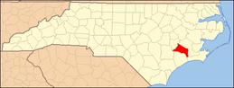 | |
| Unincorporated communities | ||
| Authority control |
|
|---|