Tornado, West Virginia
Tornado[3] is a census-designated place (CDP) [4] in Kanawha County, West Virginia, United States. Tornado is also known as "Upper Falls",[3] the name recognized by the U.S. Census Bureau at the time of the 2010 census.[5] The United States Board on Geographic Names declared the community's official name to be Tornado in 2013 due to a request from the Kanawha County Commission, which determined that residents of the community supported the name Tornado over Upper Falls.[6] It is also known as "Andrews Heights", "Big Bend" and "Upper Falls of Coal River".[3]
Tornado, West Virginia | |
|---|---|
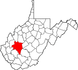
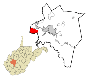 Location in Kanawha County and state of West Virginia. | |
| Coordinates: 38°20′34″N 81°50′39″W | |
| Country | United States |
| State | West Virginia |
| County | Kanawha |
| Area | |
| • Total | 17.2 sq mi (44.5 km2) |
| • Land | 16.9 sq mi (43.8 km2) |
| • Water | 0.2 sq mi (0.6 km2) |
| Elevation | 614 ft (187 m) |
| Population | |
| • Total | 3,701 |
| • Density | 219/sq mi (84.4/km2) |
| Time zone | UTC-5 (Eastern (EST)) |
| • Summer (DST) | UTC-4 (EDT) |
| ZIP Codes | 25177, 25202 |
| Area code(s) | 304 & 681 |
| GNIS feature ID | 1555859 |
| FIPS code | 54-82180 |
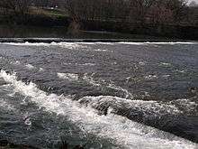
The Coal River bisects the community and gives it its historical name from the cascading waters of its Upper Falls.[7]
At 17.2 square miles (44.5 km2), Tornado is the largest CDP in the state of West Virginia.[8] As of the 2010 census, its population was 3,701.[5]
Tornado is in the Charleston, West Virginia metropolitan area.
Geography
Tornado[9] is located at 38°20′34″N 81°50′39″W (38.342872, −81.844296).[1]
According to the United States Census Bureau, the Tornado CDP has a total area of 17.18 square miles (44.49 km2), of which 16.93 square miles (43.84 km2) are land and 0.25 square miles (0.64 km2), or 1.45%, are water.[5]
The United States Geological Survey locates the community's namesake Upper Falls of Coal River at 38°20′33″N 81°50′29″W.[7]
Demographics
As of the census of 2010,[10] there were 3,701 people, 1,458 households, and 1,072 families residing in the community. The population density was 218.6 people per square mile (84.4/km²). There were 1,549 housing units at an average density of 91.7/sq mi (35.3/km²). The racial makeup of the community was 96.8% White, 1.1% African American, 0.4% American Indian and Alaska Natives, 0.3% Asian, 0.1% from other races, and 1.3% from two or more races. Hispanic or Latino of any race were 0.4% of the population.
There were 1,458 households out of which 33.6% had children under the age of 18 living with them, 59.3% were married couples living together, 9.6% had a female householder with no husband present, 4.6% had a male householder with no wife present, and 26.5% were non-families. 20.9% of all households were made up of individuals, and 8.1% had someone living alone who was 65 years of age or older. The average household size was 2.54, and the average family size was 2.93.
The community's age distribution was 19.4% under the age of 15, 10.2% from 15 to 24, 25.2% from 25 to 44, 31% from 45 to 64, and 14.2% who were 65 years of age or older. The median age was 41 years. For every 100 females there were 97.9 males. For every 100 females age 18 and over, there were 96.4 males.
2000 data
In 2000, the Upper Falls CDP was named Tornado; the Tornado CDP covered a smaller area than the Upper Falls CDP does now.
As of the census[11] of 2000, there were 1,111 people, 419 households, and 330 families residing in that CDP. The population density was 309.0 people per square mile (119.2/km²). There were 437 housing units at an average density of 121.6/sq mi (46.9/km²). The racial makeup of the CDP was 97.21% White, 0.36% African American, 0.27% Asian, 0.09% Pacific Islander, 0.09% from other races, and 1.98% from two or more races. Hispanic or Latino of any race were 0.54% of the population.
There were 419 households out of which 37.2% had children under the age of 18 living with them, 68.7% were married couples living together, 8.6% had a female householder with no husband present, and 21.2% were non-families. 17.7% of all households were made up of individuals and 6.7% had someone living alone who was 65 years of age or older. The average household size was 2.65 and the average family size was 3.01.
In Tornado the population was spread out with 26.8% under the age of 18, 6.2% from 18 to 24, 32.2% from 25 to 44, 23.7% from 45 to 64, and 11.1% who were 65 years of age or older. The median age was 37 years. For every 100 females, there were 98.7 males. For every 100 females age 18 and over, there were 91.7 males.
The median income for a household in the CDP was $50,000, and the median income for a family was $50,350. Males had a median income of $31,932 versus $25,670 for females. The per capita income for the CDP was $18,999. About 2.3% of families and 3.1% of the population were below the poverty line, including 6.3% of those under age 18 and none of those age 65 or over.
History
The Upper Falls of Coal River was discovered in 1742 by John Peter Salling during an expedition along the Coal River. Salling and four companions each received a governor's commission from the state of Virginia to explore the territory east of the Mississippi River, in return for 10,000-acre (4,000 ha) land grants. It was this group that also discovered coal along the banks of the Coal River.
It was not until after the Revolutionary War that European settlers began moving into the area. Even then, the few[12] who survived the attacks of the native peoples usually fled to safer destinations. But by around 1800, a gristmill[13] was established by Joseph Thomas at the Upper Falls which continued in operation until the 1930s.
Beginning about 1830, timber harvested from the region was floated on the Coal River to Saint Albans. At the same time, great quantities of marketable cannel coal were found on the upper Coal River. However, only at periods of high water could logs and shallow wooden boats loaded with coal be drifted over the Upper Falls and Lower Falls and on down the river.
A system of wooden-crib locks and dams designed to make Coal River navigable[14] was constructed in the 1850s to transport cannel coal, bituminous coal, coal oil and timber to market. This began the era of two-way commercial steamboat traffic on the river. The Upper Falls was the site of Upper Falls Lock and Dam,[15][16] and Edward Kenna, who also developed a sawmill[17] at the Upper Falls around 1850, was lockmaster;[18] his son, John Edward Kenna, later served as U.S. senator from West Virginia. Damage caused by ongoing flooding and the outbreak of the Civil War suspended steam tug navigation of Coal River. Traffic resumed after the war, but ended permanently in 1881.
From 1858, at least ten failed attempts were made to build a rail line up the Coal River. Finally, under the direction of General Cornelius Clarkson Watts, a Confederate veteran, construction of the Coal River and Western Railway began in 1902 and was completed in 1904. The lasting economic boom brought by the railroad to the region saw the bustling Upper Falls Station[19] offer daily service for both passengers and freight. Timber extraction ended in the 1920s, but the rail line[20] through Upper Falls, now owned by CSX Transportation, still transports massive amounts of bituminous coal to global markets.
There was a rapid influx of people to the area during and soon after World War II, and many came to live in Tornado. They found employment in the defense and chemical manufacturing industries in the Kanawha Valley and benefited from economic prosperity as a result. Today, Tornado is a residential suburb and recreation destination of the Charleston metropolitan area.[21]
Post offices
The Upper Falls of Coal Post Office, the first to serve the area, was established in 1851.[22][23] During Reconstruction, it was replaced by a post office named Tornado in 1881.[24][25] Today, residents in the northern portion of the Upper Falls CDP receive mail service from the Saint Albans Post Office at ZIP Code 25177. Residents in the southern portion of the Upper Falls CDP receive mail through the Tornado Post Office at ZIP Code 25202. This is currently the only one of the two post offices to support mail delivery using the city name Upper Falls.[26]
Other names
Since the earliest European settlers moved into the area in the 1700s, Tornado was known as Upper Falls, Upper Falls of Coal, Upper Falls of Coals, Upper Falls Coal River, Upper Falls of Coal River, Upper Falls of the Coal River and Upper Falls on Coal River.[27]
Andrews Heights is an area of Upper Falls named for landowner R. Carl Andrews,[28] who served as mayor of Charleston from 1947 to 1950[29] and was a Democratic candidate for governor of West Virginia in 1940.[30] Andrews Heights Elementary School was named for Mayor Andrews.
Big Bend is an area of Upper Falls that is named for the Big Bend of Coal River.[31] The river's Big Bend circumscribes Big Bend Golf Course, which also takes its name.
The official name "Tornado" first appeared when a new post office opened in the community in 1881.[24][25]
Transportation
During its history, transportation infrastructure serving Tornado has included roads, rail and water transport.
Highways
The primary means of transportation throughout the CDP today is by secondary highways.
In a clockwise direction on the map, Coal River Road (Kanawha County Highway 3) intersects the northern boundary of Upper Falls at Tear Drop Lane (private). Dogwood Road (CH 6/6) crosses the northern border at the Armstrong Tunnel. Smith Creek Road (CH 9) encompasses Upper Falls Intersection[32] and Upper Falls Crossing,[33] then demarcates the CDP to the east at Dry Ridge Road (CH 8). Coal River Road (CH 9/1) bisects Upper Falls, as it also crosses the southern border at the Lincoln County line. Falls Creek Road (CH 3) intersects the southern boundary at the Lincoln County line, as well. Woods Drive (CH 1/3) crosses to the west at the Putnam County line. Finally, Browns Creek Road (CH 1) delimits the CDP at the intersection of Bryants Branch Road (CH 3/3) to the north and proceeds to its terminus at the Midland Trail.[34]
Rail
The Coal River subdivision, a CSX Transportation main line, runs parallel to the Coal River, dividing Tornado from north to south. Its primary use is to transport coal from the Southern West Virginia coalfields to global markets. There was once a railroad station[19] in the community with the name "Upper Falls Station".[21]
Education
Educational opportunities available to Tornado students are provided by:
- Andrews Heights Elementary School, 7776 Coal River Road
- Humphreys After School Program, 7799 Coal River Road
Recreation
Tornado offers numerous recreational possibilities:[35]
Religion
Churches of the following Christian denominations serve the spiritual needs of Tornado residents:
- Browns Creek Church of God, 2550 Browns Creek Road
- Humphreys Memorial United Methodist Church, 7799 Coal River Road
- New Hope Baptist Church, 9414 Coal River Road
- Pleasant Hill Baptist Church, 7398 Smith Creek Road
- Riverview Freewill Baptist Church, 10603 Coal River Road
- Tornado Apostolic Church, 1100 Gore Addition Road
References
- "US Gazetteer files: 2010, 2000, and 1990". United States Census Bureau. February 12, 2011. Retrieved April 23, 2011.
- "U.S. Census website". United States Census Bureau. Retrieved May 14, 2011.
- United States Geological Survey "Tornado Populated Place"
- United States Geological Survey "Upper Falls Census Designated Place"
- "Geographic Identifiers: 2010 Census Summary File 1 (G001), Upper Falls CDP, West Virginia". American FactFinder. U.S. Census Bureau. Archived from the original on February 13, 2020. Retrieved July 12, 2019.
- "Tornado gets its name back". Charleston Gazette-Mail. March 14, 2013. Retrieved July 3, 2016.
- United States Geological Survey "Upper Falls of Coal River"
- United States Census Bureau "Upper Falls CDP, West Virginia 2010 Geographic Profile Data"
- Upper Falls, West Virginia Geographic Features UpperFalls.jimdo.com
- United States Census Bureau "Upper Falls CDP, West Virginia 2010 Demographic Profile Data"
- "U.S. Census website". United States Census Bureau. Retrieved January 31, 2008.
- United States Geological Survey "Upper Falls Cemetery"
- United States Geological Survey "Upper Falls Gristmill (historical)"
- United States Geological Survey "Upper Falls Channel"
- United States Geological Survey "Upper Falls Lock"
- United States Geological Survey "Upper Falls Dam"
- United States Geological Survey "Upper Falls Sawmill (historical)"
- United States Geological Survey "Upper Falls Lockmaster House (historical)"
- United States Geological Survey "Upper Falls Station (historical)"
- United States Geological Survey "Upper Falls Siding"
- Courtesy of Dr. William H. Dean, PhD, from Coal, Steamboats, Timber and Trains: The Early Industrial History of St. Albans, West Virginia & The Coal River, 1850–1925 "Archived copy". Archived from the original on April 26, 2012. Retrieved December 14, 2011.CS1 maint: archived copy as title (link) UpperFallsWV.blog.com
- National Archives Microfilm Publication M841, Record of Appointment of Postmasters, 1832 – September 30, 1971. Richard C. Chandler appointed postmaster, Upper Falls of Coal, WV, 26 September 1851
- United States Postal Service, "Postmaster Finder". Upper Falls of Coal Post Office, 26 September 1851 to 1876-01-21 and 1877-10-10 to 1880-11-15. Retrieved 2014-12-18.
- National Archives Microfilm Publication M841, Record of Appointment of Postmasters, 1832 – September 30, 1971. John H. Sutherland appointed postmaster, Tornado, WV, 6 July 1881
- United States Postal Service, "Postmaster Finder". Tornado Post Office, 6 July 1881 to present. Retrieved 2014-12-18.
- United States Postal Service "ZIP Code Lookup"
- From Upper Falls to Tornado and Back TornadoWV.webs.com
- Kanawha County Clerk, Map Book 13, Number 70, dated 1948
- The Political Graveyard "Index to Politicians: Andrews"
- The West Virginia Encyclopedia "Matthew Mansfield Neely"
- United States Geological Survey, ID Number 7728 "Big Bend"
- United States Geological Survey "Upper Falls Intersection"
- United States Geological Survey "Upper Falls Crossing"
- Metro 911 of Kanawha County Metro911.org
- Upper Falls, West Virginia Recreation UpperFalls.weebly.com
- United States Geological Survey "Upper Falls Beach"
- United States Geological Survey "Upper Falls Landing"
- United States Geological Survey "Upper Falls Point"
- United States Geological Survey "Walhonde Upper Falls Walking Trail"
External links
- History of Upper Falls, West Virginia
- Upper Falls, West Virginia Geographic Features
- Upper Falls, West Virginia Recreation