Torit
Torit توريت Hatiha | |
|---|---|
| Nickname(s): Wok leheyek | |
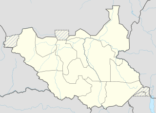 Torit توريت Location in South Sudan | |
| Coordinates: 04°24′29″N 32°34′30″E | |
| Country | |
| State | Torit State |
| County | Torit County |
| Municipality | 19 August 2013 |
| Government | |
| Elevation | 615 m (2,018 ft) |
| Population (2014 Estimate) | |
| • Total | 138,960 |
| • Summer (DST) | +3GMT |

Torit is a city in South Sudan.
Location
The city is located in Torit County in Torit State,[1] in the southeastern part of South Sudan, close to the International border with the Republic of Uganda. Its location lies approximately 150 kilometres (93 mi), by road, east of Juba, the capital and largest city in that country.[2] The coordinates of Torit are:4° 24' 28.80"N, 32° 34' 30.00"E (Latitude:4.4080; Longitude:32.5750).
Overview
Pajok is the Payam seat of Magwi County. It is also the Payam of Eastern Equatoria State, one of the ten (10) states which constitute South Sudan. The town boasts of an airport, two hospitals, several primary schools and two secondary schools. The main road from Juba, South Sudan to [Pogee], Uganda, passes through Magwi also the alternative road to Kenya via Torit passes through Lokiciogyo town.
History
In 1955 there was a slaughter in Torit during an Equatoria Corps riot.[3] In 1964 the military government in Khartoum closed "all the Christian mission schools" in the area[4] Torit was upgraded to Municipality status administered by a mayor on August 19, 2013.[5]
Population
The population of Torit was estimated at about 20,050, in 2004,[6] and, according to census results, 33,657 in 2008.[7]
Points of interest
The following points of interest are found in Torit:
- Fr Saturlino Ohure Mausoleum
- The offices of Torit Town Council
- The headquarters of Torit County
- The headquarters of Eastern Equatoria State
- Dr John Garang Memorial Secondary School, Torit
- Torit Day Secondary School
- Torit East Primary School
- Torit Hospital
- Torit State Hospital
- The Juba-Lokichogio Road - The road, which is the primary land route to and from Kenya, passes through Torit
- Torit Airport - A small civilian airport
- Lomoliha Market - The central market for the town.
- Johnson Akio Secondary School
- Fr. saturlino Ohure Secondary School
References
- Nakimangole, Peter Lokale (22 April 2016). "Additional Counties In Torit And kapoeta States Established". Gurtong. Retrieved 20 August 2016.
- Estimated Road Distance Between Juba And Torit With Map
- Richard Crockett (2010). Yale University Press. Sudan: Darfur and the Failure of an African State, p. 45. ISBN 9780300162738.
- Richard Crockett (2010). Yale University Press. Sudan: Darfur and the Failure of an African State, p. 45-46. ISBN 9780300162738.
- Ijoo, Bosco (20 August 2013). "Eastern Equatoria to upgrade three towns to municipalities". Sudan Tribune. Retrieved 22 August 2013.
- Estimated Population In 2004
- Statistical Yearbook for Southern Sudan Archived 2012-11-13 at the Wayback Machine. Southern Sudan Centre for Census, Statistics and Evaluation, 2010, p. 31 (PDF; 11,6 MB)
External links
| Wikimedia Commons has media related to Torit. |
| Counties | 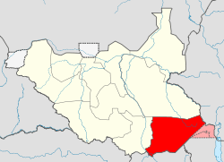 | |
|---|---|---|
| Principal towns | ||
| Airports | ||
| Rivers | ||
| Mountains | ||
| Communities | ||