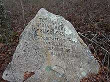
Tomaquag Rock Shelters
The Tomaquag Rock Shelters (RI-HP-1) are a prehistoric rockshelter site off Maxson Hill Road (formerly Burdickville Road) in Hopkinton, Rhode Island. The shelters are located under two east-facing granite outcrops in the valley drained by Tomaquag Brook. First discovered in the late 1950s by Nathan Kaye, materials recovered from test excavations resulted in the dating the occupation of one shelter to 800 BCE and the other to 800 CE. Materials recovered include projectile points, stone knives, and evidence of stone tool construction. Both sites included evidence pointing to the presence of a fire pit.[2]
Tomaquag Rock Shelters | |
 | |
  | |
| Location | Maxson Hill Rd., Hopkinton, Rhode Island |
|---|---|
| Coordinates | 41°26′19″N 71°46′32″W |
| Area | 0.25 acres (0.10 ha) |
| NRHP reference No. | 77000011[1] |
| Added to NRHP | August 12, 1977 |
The shelters were added to the National Register of Historic Places in 1977.[1]
The shelters were gifted from Nathan Kaye to the State of Rhode Island in 1982. In 1996 the State Properties Committee entered into a "Park Use Agreement" with the Town of Hopkinton to preserve the shelter site. The Hopkinton Planning Board entered a requirement that the cultural aspects of the shelter be protected in a Master Plan agreement with the developers of a proposed solar farm across the road from the site on January 4, 2019.
References
- "National Register Information System". National Register of Historic Places. National Park Service. January 23, 2007.
- "NRHP nomination for Tomaquag Rock Shelters" (PDF). Rhode Island Preservation. Retrieved 2014-09-17.
| Wikimedia Commons has media related to Tomaquag Rock Shelters. |
| Topics | |
|---|---|
| Lists by state |
|
| Lists by insular areas | |
| Lists by associated state | |
| Other areas | |
| Related | |
| |