Tolaga Bay
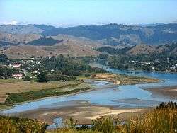
Tolaga Bay (Māori: Uawa) is both a bay and small town on the East Coast of New Zealand's North Island located 45 kilometres northeast of Gisborne and 30 kilometres south of Tokomaru Bay.
Tolaga Bay Uawa (Māori) | |
|---|---|
Town | |
 Tolaga Bay | |
 Tolaga Bay Location in New Zealand | |
| Coordinates: 38°22′S 178°18′E | |
| Country | New Zealand |
| Region | Gisborne Region |
| Time zone | UTC+12 (NZST) |
| • Summer (DST) | UTC+13 (NZDT) |
| Postcode | 4077 |
| Area code(s) | 06 |
The region around the bay is rugged and remote, and for many years the only access to the town was by boat. Because the bay is shallow, a long wharf - the second longest in New Zealand (600m) after the Tiwai Point wharf at Bluff (1,500m) - was built in the 1920s to accommodate visiting vessels. The last cargo ship to use the wharf loaded a cargo of maize in 1967.[1] In the 1830s there was a thriving flax trade involving early European traders like Barnet Burns.[2] By 1998, the wharf had deteriorated and was in danger of being closed. In response, the Tolaga Bay Save the Wharf Trust raised funds and gained technical help to restore it. The wharf has now been re-opened and the refurbishment project should finish by May 2013.[3]
The Uawa River reaches the Pacific Ocean in the middle of Tolaga Bay. There is a bar at the river mouth with around 2 metres of water at high tide. The Uawa River is called the Hikuwai further up. Tributaries include the Waiau and the Mangaheia. In 2018 heavy rains washed huge amounts of discarded forestry timber (or slash) down the Uawa River, which choked up the estuary, covered the beach, and caused extensive damage to farms and houses.[4]
An island in the bay was originally named Spöring Island by Cook, after his expedition's assistant naturalist and instrument maker, Herman Spöring, a Finnish botanist. It is however today again known by its Māori name, Pourewa.
The town is a popular holiday spot. Its population is predominantly Māori, a centre of the Te Aitanga-a-Hauiti iwi and home of Ariki - Te Kani a Takirau[5] and Tohunga - Rangiuia.[6]
History and culture

Tolaga Bay was named by Lt. James Cook in 1769. Described as "an obvious corruption of a Maori name", the exact derivation of the name is unclear. It may have been a misunderstanding of "teraki" or "tarakaka", referring to the local south-westerly wind rather than the place.[7][2] The original Māori name is Uawa Nui A Ruamatua (shortened to Uawa), and some local residents now refer to the area as Hauiti, and themselves as Hauitians[8] from the local iwi Te Aitanga-a-Hauiti.
At the time of Cook's visit, according to Anne Salmond, here "a famous school of learning (Known as Te Rawheoro) that specialized in tribal lore and carving was sited..." Tupaia, the Raiatean navigator accompanying Cook since Tahiti, met with the tohunga, priest, of this whare wananga. Tupaia exchanged news of the "Māori island homelands, known to Māori as 'Rangiatea' (Ra'iatea), 'Hawaiki' (Havai'i, the ancient name for Rai'iatea), and 'Tawhiti' (Tahiti)." The Māori viewed Tupaia as a tohunga, and many children born during his visit bore his name. Additionally, Tupaia made a sketch within the rock shelter of Opoutama ('Cook's Cove' or 'Tupaia's Cave'), according to Joel Polack.[9]
Two marae are located south of the main township:
- Te Rawheoro Marae and Te Rawheoro meeting house is a meeting place of the Ngāti Porou hapū of Ngāti Patu Whare, Te Aitanga a Hauiti and Ngāti Wakarara.
- Hauiti Marae and Ruakapanga meeting house is a meeting place of the Ngāti Porou hapū of Ngāi Tutekohi, Ngāti Kahukuranui and Te Aitanga a Hauiti.[10][11]
Three marae are located north of the main township:
- Puketawai Marae and Te Amowhiu meeting house is a meeting place of the Ngāti Porou hapū of Te Whānau a Te Rangipureora.
- Hinemaurea ki Mangatuna Marae and Hinemaurea meeting house is a meeting place of Ngāti Kahukuranui, a hapū of Te Aitanga-ā-Hauiti.
- Ōkurī Marae and meeting house is a meeting place of the Ngāti Porou hapū of Ngāti Ira and Ngāti Kahukuranui.[10][11]
Education
Tolaga Bay Area School is a Year 1-15 co-educational state area school.[12] In 2019, it was a decile 2 school with a roll of 242.[13]
Te Kura Kaupapa Māori o Mangatuna is a Year 1–8 co-educational Māori immersion school.[14] In 2019, it was a decile 1 school with a roll of 39.[15]
References
- Tolaga Bay, a history of the Uawa District : Tolaga Bay School Centennial, 1888-1988.
- , GisborneNZ.com, accessed 6 June 2018
- Gisborne Herald, Friday, March 08, 2013, Project to restore old wharf nears end
- Arnold, Naomi (July–August 2018). "When the rain came for Tolaga Bay". New Zealand Geographic (152): 10–15.
- "Te Kararoa". Register of Historic Places. Heritage New Zealand. Retrieved 21 December 2009.
- "Taharangi". Register of Historic Places. Heritage New Zealand. Retrieved 21 December 2009.
- A. W. Reed, A Dictionary of Maori Place Names, p 119, A. H. & A. W. Reed, Wellington 1961
- (in the comments)
- Salmond, Anne (2010). Aphrodite's Island. Berkeley: University of California Press. pp. 228-230, 235, 385. ISBN 9780520261143.
- "Te Kāhui Māngai directory". tkm.govt.nz. Te Puni Kōkiri.
- "Māori Maps". maorimaps.com. Te Potiki National Trust.
- "Education Review Office Report". ero.govt.nz. Education Review Office.
- "Ministry of Education School Profile". educationcounts.govt.nz. Ministry of Education.
- "Education Review Office Report". ero.govt.nz. Education Review Office.
- "Ministry of Education School Profile". educationcounts.govt.nz. Ministry of Education.
External links

- "Tolaga Bay History" personal site
- "Gisborne & Eastland"
- Gisborne District Council