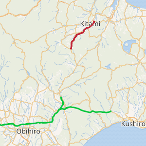
Tokachi-Okhotsk Expressway
The Tokachi-Okhotsk Expressway (十勝オホーツク自動車道, Tokachi Ohōtsuku Jidōsha-dō) is a two-lane national expressway in Tokachi Subprefecture and Okhotsk Subprefecture, Hokkaido, Japan. As of December 2018, the expressway is under construction to connect to link to the Kitami Route of the Dōtō Expressway in Ashoro. As of December 2018, it connects Rikubetsu to Kitami, the most populous city in Okhotsk Subprefecture, on the Sea of Okhotsk coast. It is owned and operated by Ministry of Land, Infrastructure, Transport and Tourism and is signed as E61 under their "2016 Proposal for Realization of Expressway Numbering."[2]
| |
|---|---|
| |
| Route information | |
| Maintained by Ministry of Land, Infrastructure, Transport and Tourism | |
| Length | 38.3 km[1] (23.8 mi) |
| Existed | 2013–present |
| Highway system | |
| National highways of Japan Expressways of Japan | |

History
The first section of the expressway to open was a 5.8-kilometer (3.6 mi) long section between Kitami-higashi Interchange and Kitami-nishi Interchange on 31 March 2013. Later that year on 24 December, Kitami-chūō and Kitami-kitagami interchanges were added along the section that opened in March. On 8 November 2015, a 12-kilometer (7.5 mi) long section between Kunneppu Interchange and Kitami-nishi Interchange opened to traffic.[3] On 9 October 2017, a 16-kilometer (9.9 mi) long section between Rikubetsu-Shōtobetsu Interchange and Kunneppu Interchange opened to traffic.[4]
Future
The Tokachi-Okhotsk Expressway is planned to have a total length of approximately 79 kilometers (49 mi) upon completion.[3]
Junction list
The entire expressway is in Hokkaido.
| Location | km | mi | Exit | Name | Destinations | Notes | |
|---|---|---|---|---|---|---|---|
| Through to | |||||||
| Ashoro | 0 | 0.0 | 1 | Ashoro | Northbound exit, southbound entrance. Tollbooth. Southern terminus | ||
| 50.9 km gap in the expressway, connection is made by | |||||||
| Rikubetsu | 50.9 | 31.6 | — | Rikubetsu-Shōtobetsu | Northbound entrance, southbound exit | ||
| Kunneppu | 66.9 | 41.6 | — | Kunneppu | Hokkaido Route 143– Rikubetsu, Kitami | ||
| Kitami | 78.9 | 49.0 | 1 | Kitami-nishi | Hokkaido Route 261– Asahikawa, Tsubetsu | ||
| 79.9 | 49.6 | 1-1 | Kitami-kitagami | Hokkaido Route 27– Tsubetsu, Tokoro | Northbound entrance, southbound exit | ||
| 84.2 | 52.3 | 2 | Kitami-chūō | Hokkaido Route 217– Kitami Station, Bihoro | |||
| 87.0 | 54.1 | 2-1 | Kitami-Kawahigashi | Onion Road | |||
| 89.2 | 55.4 | 3 | Kitami-higashi | Hokkaido Route 1024– Abashiri, Bihoro | Northbound exit, southbound entrance. Current northern terminus | ||
| 1.000 mi = 1.609 km; 1.000 km = 0.621 mi | |||||||
References
- "Tokachi-Okhotsk Expressway Data" (PDF). Retrieved 7 December 2018.
- "Japan's Expressway Numbering System". www.mlit.go.jp.
- "平成27年10月13日お知らせ十勝オホーツク自動車道 足寄~北見間 「訓くん子ねっ府ぷIC~北きた見み西にしIC」〈通行無料〉が開通します ~オホーツクの観光振興・安心安全・地域産業に貢献します~" (PDF) (in Japanese). Retrieved 11 December 2019.
- "十勝オホーツク自動車道「陸別りくべつ小しょう利別としべつIC~訓子府く ん ね っ ぷIC」が 平成29年10月9日(月)16時に開通します" (PDF) (in Japanese). Retrieved 11 December 2019.