Tofua
Tofua Caldera is the summit caldera of a steep-sided composite cone that forms Tofua Island in Tonga. Tofua forms part of Tonga's Ha'apai island group.
| Tofua Caldera | |
|---|---|
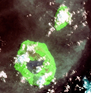 Tofua Island (lower left) and neighbouring Kao Island, Tonga, Pacific Ocean | |
| Highest point | |
| Elevation | 515 m (1,690 ft) |
| Prominence | 515 m (1,690 ft) |
| Listing | List of volcanoes in Tonga |
| Coordinates | 19°45′00″S 175°04′30″W |
| Geography | |
 Tofua Caldera Tonga Islands, Tonga | |
| Geology | |
| Mountain type | Volcanic caldera |
| Last eruption | 2014 |

Geology
Tofua's pre-caldera activity is recorded by a sequence of pyroclastic deposits and lavas constituting the older cone, followed on the northern part of the island by froth lavas or welded and unwelded ignimbrite. Following the caldera collapse, lavas were erupted from the northern part of the island and the caldera-rim fissure zone, scoria and lavas from the caldera-wall fissure zones, pyroclastics and lavas from intracaldera cones, and recent pyroclastic fall deposits on the outer cone. Eruptive products are mainly basaltic andesites and andesites, plus occasional dacite flows within the older cone. A postcaldera cone with fumarolic activity (Lofia) is in the northern part of the caldera; a crater lake with 500 m (1,600 ft) depth occupies most of the remainder.[1]
Most historical eruptions have been small explosions from Lofia cone along the northern caldera rim. The eruptions of 1958-59 caused most of the islanders to evacuate for a year or more.
History
The Mutiny on the Bounty took place on 28th April, about 30 nautical miles (56 km; 35 mi) from Tofua. After being cast off the ship, Captain William Bligh navigated the overcrowded 23-foot (7 m) open launch on an epic 41-day voyage first to Tofua and then to the Dutch East Indies port of Kupang on Timor equipped with a quadrant, a pocket watch, sextant and a compass. The mutineers refused them charts so Bligh had to navigate to Timor from memory.[2] He recorded the distance as 3,618 nautical miles (6,701 km; 4,164 mi). He passed through the difficult Torres Strait along the way and reached Kupang on June 14.[3] The only casualty on this voyage was a crewman named John Norton who was stoned to death by the natives of Tofua, the first island they tried to land on.[4]
At Tofua (Bligh spelled it Tofoa), Bligh and eighteen loyalists sought refuge in a cave to augment their meager provisions. In the March 1968 issue of the National Geographic Magazine, Luis Marden claimed to have found this cave and the grave of John Norton.[5] Both findings were later disproved by Bengt Danielsson (who had been a member of the 1947 Kon-Tiki expedition) in the June 1985 issue of the Pacific Islands Monthly. Danielsson identified Bligh's cave as lying on the sheltered northwest coast, where Bligh identified it; Marden's cave lies on the exposed southeast coast. Additionally, Danielsson thought it highly unlikely that the Tofuans would have allotted any grave site to Norton, or that the grave, if allotted, would have been preserved for two centuries.[6]
In May 1943, a lifeboat containing 23 survivors from the Liberty ship SS Phoebe A. Hearst, which sank after being torpedoed by the Japanese submarine I19 on 30 April 1943, landed. The crew survived on shellfish and coconuts until spotted by a Lockheed Hudson patrol aircraft of the Royal New Zealand Air Force and were picked up the following day by the YMS-1 class minesweeper YMS-89 of the US Navy and taken to Tongatapu.[7]
From 1965–66, a group of six Tongan schoolboys were shipwrecked on the island of ʻAta (several hundred kilometers south of Tofua) and then survived for 15 months before being rescued by an Australian millionaire who, upon visiting the island out of curiosity, came upon the naked bearded men when scanning the island's coast through his binoculars.[8] It took the men several months to create fire and the flame was maintained through wind, rain and gale, with each taking shifts to protect it. Before making fire they lived primarily on coconuts and raw seafood. After being documented by ABC News in America the story faded away; many of the men involved live on Lifuka island.
In 2008-2009, the Swiss adventurer Xavier Rosset spent 10 months alone on the island. Having a camera, he turned his survivalist endeavor into a documentary called 300 Days alone.[9]
The oral tradition of Kao and Tofua
E. W. Gifford, recording Tongan myths and tales in the 1920s, documented this explanation for Tofua's caldera and the creation of Kao Island to the north:
"Three deities from Samoa, Tuvuvata, Sisi, and Faingaa, conspired to steal Tofua. So they came and tore up the high mountain by its very roots and its place was taken by a large lake. This enraged the Tongan gods very much and one of them, Tafakula, essayed to stop the thieves. He stood on the island of Luahako and bent over so as to show his anus. It shone so brilliantly that the Samoan deities were struck with fear, thinking that the sun was rising and that their dastardly works was about to be revealed. Hence, they dropped the mountain and fled to Samoa. The mountain became the island of Kao."[10]
See also
References
- "Tofua". Global Volcanism Program. Smithsonian Institution.
- "A Voyage to the South Sea". www.gutenberg.org. Retrieved 2020-05-07.
- "A Voyage to the South Sea". www.gutenberg.org. Retrieved 2020-05-07.
- "Pitcairn Islands Study Center". library.puc.edu. Retrieved 2020-05-07.
- danielramirez (2016-05-30). National Geographic 1968.
- "Vol. 56, No. 6 ( Jun. 1, 1985)". nla.gov.au. Retrieved 2020-05-07.
- Cressman, Robert J. (2016). The Official Chronology of the U.S. Navy in World War II. Annapolis: Naval Institute Press. ISBN 978-1-68247-154-8. OCLC 1030816142.
- Bregman, Rutger (2020-05-09). "The real Lord of the Flies: what happened when six boys were shipwrecked for 15 months". The Guardian. ISSN 0261-3077. Retrieved 2020-05-09.
- "Xavier Rosset: 300 days alone on an island". TEDxGeneva (in French). Retrieved 2020-05-07.
- Edward Winslow Gifford, Tongan myths and tales, 1924 Honolulu: Bernice P. Bishop Museum Bulletin, No. 8
External links
- United States Geological Survey
- Pitcairn Islands Study Center
- Bauer, G. R. (1970). The geology of Tofua Island, Tonga. Pacific Science, 24(3), 333-350.
- Tonga Visitors Bureau (Ministry of Tourism)
- 300 days of desert island solitude
- 300 Days alone documentary