Titoki, New Zealand
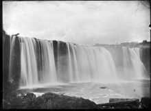
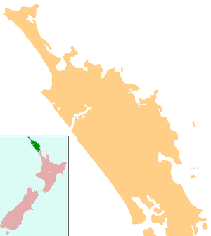
Titoki (Māori: Tītoki) is a locality in the Mangakahia Valley of the Northland Region of New Zealand's North Island.[1] Whangarei is 26 km (16 miles) to the east. The Wairua River passes to the east of Titoki, and the Mangakahia River to the west.[2][3] A hydroelectric plant has been operating at Wairua Falls since 1916.[4] It was upgraded to produce 5.4 Gwh per year in 2007.[5]
Titoki | |
|---|---|
 Titoki | |
| Coordinates: 35°44′02″S 174°03′26″E | |
| Country | New Zealand |
| Region | Northland Region |
| District | Whangarei District |
The local Korokota Marae is a tribal meeting ground of the Ngāpuhi hapū of Te Parawhau and the Ngāti Whātua hapū of Te Parawhau.[6] It features the Tikitiki o Rangi meeting house.[7]
Mangakahia Area School is a coeducational composite school (years 1-15), with a decile rating of 3 and a roll of 157.[8] The school, previously called Titoki District High School, celebrated its centennial in 2007.[9]
Notable people
- Tania Roxborogh, writer
Notes
- Hariss, Gavin. "Titoki, Northland". topomap.co.nz. NZ Topo Map.
- Peter Dowling (editor) (2004). Reed New Zealand Atlas. Reed Books. Map 7. ISBN 0-7900-0952-8.CS1 maint: extra text: authors list (link)
- Roger Smith, GeographX (2005). The Geographic Atlas of New Zealand. Robbie Burton. Map 24. ISBN 1-877333-20-4.
- "Annual Report" (PDF). Northpower. 2005. p. 9. Archived from the original (PDF) on 14 October 2008.
- "Power to Northland as hydro scheme expands". New Zealand Government. 7 November 2007. Retrieved 17 April 2008.
- "Te Kāhui Māngai directory". tkm.govt.nz. Te Puni Kōkiri.
- "Māori Maps". maorimaps.com. Te Potiki National Trust.
- "Te Kete Ipurangi - Mangakahia Area School". Ministry of Education. Archived from the original on 14 September 2012.
- "Mangakahia Area School Centennial Celebrations". Education Gazette New Zealand. 84 (15). 22 August 2005.