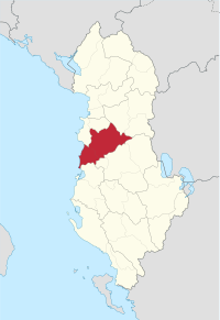
Tirana County
Tirana County (Albanian: Qarku i Tiranës) is one of the 12 counties of the Republic of Albania, with the capital in Tirana. The county spans 1,652 square kilometres (638 sq mi) and had a total population of 906,166 people as of 2020. The county borders on the counties of Durrës, Dibër, Elbasan, Fier, and the Adriatic Sea.
Tirana County Qarku Tiranë | |
|---|---|
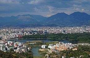 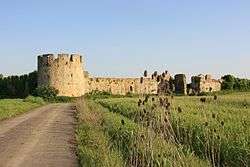   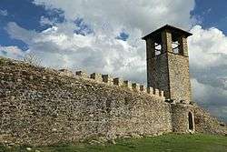  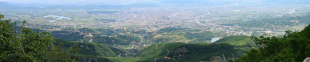 Clockwise from top: Tirana, Fortress of Bashtovë, Petrelë Castle, Golem Beach, Prezë Castle, Krrabë and View of Tirana from Mount Dajt | |
 Emblem | |
 | |
| Coordinates: 41°15′N 19°45′E | |
| Country | |
| Seat | Tirana |
| Subdivisions | 5 municipalities, 248 towns and villages |
| Government | |
| • Council chairman | Aldrin Dalipi |
| Area | |
| • Total | 1,652 km2 (638 sq mi) |
| Elevation | 156 m (512 ft) |
| Population (2020[1]) | |
| • Total | 906,166 |
| • Density | 550/km2 (1,400/sq mi) |
| Time zone | UTC+1 (CET) |
| • Summer (DST) | UTC+2 (CEST) |
| NUTS Code | AL022 |
| Website | https://www.forum-al.com |
Tirana, the country's largest metropolitan area and the centre of the county which, with a population of 906,166 as of 2018, makes for 31.84% of Albania's population.[2]
The area has been populated since Paleolithic times dating back 10,000 to 30,000 years ago. As argued by various archaeologists, Tirana and its suburbs are filled with Illyrian toponyms as its precincts are some of the earliest regions in Albania to be inhabited. Tirana was founded as a city in 1614 although the area has been continuously inhabited since antiquity.
Mount Dajt National Park is located in Tirana County. From this area there is an excellent view of Tirana and its plain. This is the reason this place has been named as the Balcony of Tirana. Tirana is separated from the coastal plain of Durres to the west by long range of hills known as the Kodra e Gjatë, with the county borders running along the spine.
History
The area has been populated since the Paleolithic era,[3] dating back 10,000 to 30,000 years ago, as suggested by evidence from tools excavated near Mount Dajt's quarry and in Pellumba Cave. As argued by various archaeologists, Tirana and its suburbs are filled with Illyrian toponyms, as its precincts are some of the earliest inhabited regions in Albania.[4] The Illyrians called the settlement Tërana.
The oldest discovery in downtown Tirana was a Roman house, later transformed into an aisleless church with a mosaic-floor, dating to the 3rd century A.D., with other remains found near a medieval temple at Shengjin Fountain in the eastern suburbs. A castle possibly called Tirkan or Theranda, whose remnants are found along Murat Toptani Street, was built by Emperor Justinian in 520 A.D. and restored by Ahmed Pasha Toptani in the 18th century.[4] The area had no special importance in Illyrian and classical times. In 1510, Marin Barleti, an Albanian Catholic priest and scholar, in the biography of the Albanian national hero Skanderbeg referred to this area as a small village.[5]
Geography
Tirana County is located in the central part of Albania. It borders to the Adriatic Sea in the west. The climate is generally Mediterranean but varies by local topography. There are diverse microclimates in the county. Summers are dry while heavy rains are experienced during the winter. Climate conditions near Tirana are conducive to farming and related agricultural industries.
Mount Dajt is a mountain and national park in Tirana County, to the east of Tirana. Its highest peak is at 1,613 m (5,292 ft). In winter, the mountain is often covered with snow, and it is a popular retreat to the local population of Tirana that rarely sees snow falls. Its slopes have forests of pines, oak and beech, while its interior contains canyons, waterfalls, caves, a lake, and an ancient castle. In addition to the forests and beautiful mountain landscapes with many wild flowers, numerous mammals are protected as well. In the park there exist wild boar, eurasian wolf, red fox, European hare, brown bears and wildcats. In the lower part of the mountains the vegetation is scrub determined with much heath, myrtle and fragaria. Oak dominates at around the 1,000 metres altitude zone following with beech forests with some conifers. Perched on the top there is almost no vegetation.
One of Tirana's main water sources, Bovilla Lake is located to the northeast of Brar village. On the other extremity of the park, along Erzeni River is found the impressive Pellumbas Cave, Erzeni Canyon and Peshkashesh Dam.
The biggest river is the Erzeni River which flows through Bërzhitë, Petrelë, Vaqarr, Ndroq, Shijak and Sukth. It flows into the Adriatic Sea near Sukth, north of Durrës.
 Bovilla reservoir
 Mount Dajt
Administrative divisions
Until 2000, Tiranë County was subdivided into two districts: Kavajë, and Tiranë. Since the 2015 local government reform, the county consists of the following 5 municipalities: Kamëz, Kavajë, Rrogozhinë, Tirana and Vorë.[6] Before 2015, it consisted of the following 29 communes:
The municipalities consist of about 250 towns and villages in total. See Villages of Tirana County for a structured list.
Demographics
According to the last national census from 2011 the county had 749,365 inhabitants.[7] It counted the following numbers in the county per ethnic group:[7]
- Albanians = 630,203 (84.1%)
- Macedonians = 513 (0.07%)
- Montenegrins = 44 (0.01%)
- Aromanians = 856 (0.11%)
- Romani = 2,371 (0.32%)
- Egyptians = 790 (0.11%)
- others = 1,042 (0.14%)
- no answer = 95,071 (12.69%)
Islam is by far the largest religion in the county, forming 38.54% of the total population (27,815 people). There are also some Bektashi Muslims with 8.48% (6,118 people), 7.15% percent consisting of believers without a denomination (22,186 people) and Christians forming 19.65% of the county's population (Orthodox (17.43%) (15,295 people), Evangelists (0.08% (59 people) (and Roman Catholics) (2.07%) (1,493 people).
Culture
Monuments


- Petrelë Castle, its history dates back to Saint Justinian the Great and was built in the 6th century AD.
- Skanderbeg Monument, it commemorates Skanderbeg, a 15th-century nobleman who is a national hero in Albania for resisting the Ottomans.
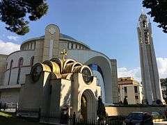
- Orthodox Cathedral, is the third-largest Orthodox cathedral located on the Balkan Peninsula.
- Et'hem Bey Mosque, is an 18th-century mosque, frescoes outside and in the portico depict trees, waterfalls and bridges – motifs rarely seen in Islamic art.
- Mother Albania, the statue figuratively represents the country as a mother guarding over the eternal slumber of those who gave their lives for her.
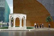
- Mausoleum of the Albanian Royal Family, it holds the remains of King Zog and other members of his family.
- Kapllan Pasha Tomb, the tomb was built in the early 19th century, with carved stones and has an octagonal shape. The columns are made of stone, and placed also on stone bases, with capitals with plant decor on the surface.
- Sacred Heart Catholic Church, the church was built in 1865 as a gift from the emperor Franz Joseph I
- Clock Tower of Tirana, was built in 1822 and was the tallest building in Tirana at the time.
- Fortress of Bashtovë is a 15th century castle situated near the right banks of Shkumbin River, about 6 kilometres (4 mi) upstream from its outflow into the Adriatic Sea.
- Prezë Castle is a small castle the construction of which started in the 14th century and was completed in the early 15th century and belonged to the Thopias, a local feudal family. During 1443-1468 it was one of the core strongholds of the Albanian resistance against the Ottomans led by Skanderbeg.
- Golem area, along the coast, is a popular beach destination where many resorts, hotels, and vacation homes are located. Golem has experienced rapid urban development.
See also
| Wikimedia Commons has media related to Tiranë County. |
References
- "Popullsia e Shqipërisë". instat.gov.al (in Albanian and English). 12 June 2020. Archived from the original on 12 June 2020.
- "Popullsia e Shqipërisë" (PDF). instat.gov.al (in Albanian). 1 January 2018.
- As argued by Prof. Dr. Muzafer Korkuti, an Albanian archeologist and researcher. "Tirane si qëndër e Historisë dhe Trashëgimisë Kulturore"
- Heppner, Harald (1994). Hauptstädte in Südosteuropa: Geschichte, Funktion, nationale Symbolkraft. Wien u.a. Böhlau. pp. 133, 135. ISBN 978-3-205-98255-5.
- To know more about the history of Tirana, please consult Tirana ne shekuj: Terona, Theranda, Tirkan, Tirannea, Tirana : monografi, disa artikuj e materiale arkivore kushtuar historisë së Tiranës by Skënder Jasa. (Victoria, 1997)
- Law nr. 115/2014 Archived 2015-09-24 at the Wayback Machine
- 2011 census results Archived 2016-02-07 at the Wayback Machine
External links
| |||||||||||||||||||||||||||||||