Tidal flooding
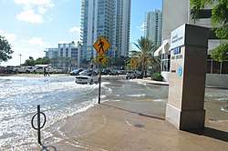
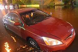
Tidal flooding, also known as sunny day flooding[1] or nuisance flooding,[2] is the temporary inundation of low-lying areas, especially streets, during exceptionally high tide events, such as at full and new moons. The highest tides of the year may be known as the king tide, with the month varying by location.
Tidal flooding is capable of majorly inhibiting natural gravity-based drainage systems in low-lying areas when it reaches levels that are below visible inundation of the surface, but which are high enough to incapacitate the lower drainage or sewer system. Thus, even normal rainfall or storm surge events can cause greatly amplified flooding effects. One passive solution to intrusion through drainage systems are one way back-flow valves in drainage ways. However, while this may prevent a majority of the tidal intrusion, it also inhibits drainage during exceptionally high tides that shut the valves. In Miami Beach, where resilience work is underway, the pump systems replace insufficient gravity-based systems.[3]
United States
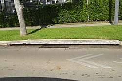
In Florida, controversy arose when state-level government mandated that the term "nuisance flooding" and other terms be used in place of terms such as sea level rise, climate change and global warming, prompting allegations of climate change denial, specifically against Governor Rick Scott. This amid Florida, specifically South Florida and the Miami metropolitan area being one of the most at risk areas in the world for the potential effects of sea level rise, and where the frequency and severity of tidal flooding events increased in the 21st century.[4] The issue is more bipartisan in South Florida, particularly in places like Miami Beach, where a several hundred million dollar project is underway to install more than 50 pumps and physically raise roads to combat the flooding, mainly along the west side of South Beach, formerly a mangrove wetland where the average elevation is less than one meter (3.3 feet).
In the Miami metropolitan area, where the vast majority of the land is below 10 ft (3.0 m), even a one-foot increase over the average high tide can cause widespread flooding. The 2015 and 2016 king tide event levels reached about 4 feet (1.2 m) MLLW, 3 feet (0.9 m) above mean sea level, or about 2 ft (0.61 m) NAVD88, and nearly the same above MHHW.[5] While the tide range is very small in Miami, averaging about 2 ft (0.61 m), with the greatest range being less than 2 m (6.6 ft),[6] the area is very acute to minute differences down to single inches due to the vast area at low elevation. NOAA tide gauge data for most stations shows current water level graphs relative to a fixed vertical datum, as well as mean sea level trends for some stations. During the king tides, the local Miami area tide gauge at Virginia Key shows levels running at times 1 foot (0.30 m) or more over datum.
Fort Lauderdale has installed over one hundred tidal valves since 2013 to combat flooding. Fort Lauderdale is nicknamed the "Venice of America" due to its roughly 165 miles (266 km) of canals.[7]
A recent University of Florida study correlated the increased tidal flooding in south Florida, at least from 2011–15 to episodic atmospheric conditions.[8] The rate was about 3/4 of an inch (19 mm) per year, versus the global rate of just over a tenth of an inch (3 mm) per year.[9]
History
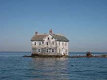
Due to changing geography such as subsidence, and poorly planned development, tidal flooding may exist separate from modern nuisance flooding associated with sea level rise and anthropocentric climate change. The widely publicized Holland Island in Maryland for example has disappeared over the years mainly due to subsidence and coastal erosion.[10] In the New Orleans area on the Gulf Coast of Louisiana, land subsidence results in the Grand Isle tide gauge showing an extreme upward sea level trend.[11]
In March 2018, South Florida experienced significant coastal erosion and flooding outside of the usual king tide or hurricane season during a Nor'easter event.[12]
See also
- Acqua alta, tidal peaks in the northern Adriatic Sea which cause flooding in the Venetian Lagoon
References
- Erik Bojnansky (March 9, 2017). "Sea levels are rising, so developers and governments need to band together: panel". The Real Deal. Retrieved March 10, 2017.
- "What is nuisance flooding?". National Oceanic and Atmospheric Administration. Retrieved December 13, 2016.
- Diana Madson (May 10, 2017). "Miami Beach spends millions to hold back the sea". Yale Climate Connections. Retrieved May 14, 2017.
- Wdowinski, Shimon; Bray, Ronald; Kirtman, Ben P.; Wu, Zhaohua (2016). "Increasing flooding hazard in coastal communities due to rising sea level: Case study of Miami Beach, Florida". Ocean & Coastal Management. 126: 1–8. doi:10.1016/j.ocecoaman.2016.03.002.
- "Water Levels - NOAA Tides & Currents (October 2016)". National Oceanic and Atmospheric Administration (NOAA). Retrieved November 1, 2016.
- "Virginia Key, FL - Station ID: 8723214". National Oceanic and Atmospheric Administration. Retrieved November 1, 2016.
- Amanda Ruggeri (April 4, 2017). "Miami's Fight Against Rising Seas". BBC News. Retrieved April 10, 2017.
- Justin Gillis (August 9, 2017). "The Sea Level Did, in Fact, Rise Faster in the Southeast U.S." The New York Times. Retrieved August 9, 2017.
- Pam Wright (August 10, 2017). "Sea Levels Have Risen Faster in Southeast U.S., and Scientists Think They Know Why". The Weather Channel. Retrieved August 10, 2017.
- Wheeler, Timothy B. (October 22, 2010). "Holland Island house collapse 'end of an era'". The Baltimore Sun. Retrieved November 2, 2016.
- "Mean Sea Level Trend 8761724 Grand Isle, Louisiana". NOAA. Retrieved November 24, 2016.
- David Sutta (March 5, 2018). "Massive Waves Push Sand, Water Inland And Cause Flooding Issues In Dania Beach". WFOR-TV. Retrieved March 8, 2018.
External links
- South Florida's Rising Seas - Sea Level Rise Documentary, South Florida PBS
| Wikimedia Commons has media related to Tidal flooding. |