Tian Shan foothill arid steppe
The Tian Shan foothill arid steppe ecoregion (WWF ID:PA0818) covers the northern and western approaches to the Tian Shan mountains, centered on Lake Issyk-Kul in Kyrgyzstan. This region receives more moisture from Central Asia, thereby supporting more vegetation and diversity of plant and animal species than the deserts to the south.[1][2]
| Ecoregion: Tian Shan foothill arid steppe | |
|---|---|
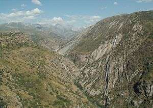 Aksu-Canyon, Kazakhstan | |
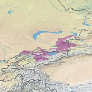 Ecoregion territory (in purple) | |
| Ecology | |
| Realm | Palearctic |
| Biome | Temperate grasslands, savannas, and shrublands |
| Geography | |
| Area | 129,000 km2 (50,000 sq mi) |
| Countries | Kazakhstan, Kyrgyzstan, China |
| Coordinates | 43°30′N 79°00′E |
Location and description
The ecoregion stretches around the lower altitudes of the Tian Shan mountain ridge, running for approximately 1,000 km from western Kyrgyzstan to a small section inside the western reaches of Xinjiang Province in China.[1] The foothills of the northwestern Tian Shan are a series of ridges and lake basins in this region. Elevations for this ecoregion are 150 - 660 meters.
Climate
Several different climate classifications are represented in the ecoregion, both semi-arid and humid. The most widespread in the northeast is cold semi-arid (Köppen climate classification (BSk)). This climate is generally characterized as having precipitation greater than a true desert, and also a colder temperature.[3][4] The western areas of the ecoregion, and the closer areas to the main ridge, are warmer, particularly in the summer, with high temperatures above 32 degrees C in July.[1]
Flora and fauna
The semi-desert of the lower foothills feature Fescue (Festuca) and feather grass (Stipa), with sagebrush and similar shrubs (genus Artemisia), and salt-tolerant tamarisk (Tamarix).[1] Common mammals include red fox, corsac fox, wolf, steppe cat, weasels, ferrets, and various voles and shrews.[1]
See also
- Ecoregions in China
References
- "Tian Shan foothill arid steppe". World Wildlife Federation (WWF). Retrieved December 28, 2019.
- "Map of Ecoregions 2017". Resolve, using WWF data. Retrieved September 14, 2019.
- Kottek, M., J. Grieser, C. Beck, B. Rudolf, and F. Rubel, 2006. "World Map of Koppen-Geiger Climate Classification Updated" (PDF). Gebrüder Borntraeger 2006. Retrieved September 14, 2019.CS1 maint: multiple names: authors list (link)
- "Dataset - Koppen climate classifications". World Bank. Retrieved September 14, 2019.