Thingoe Rural District
Thingoe Rural District was a rural district in the county of West Suffolk, England. It was created in 1894. On 1 April 1935 the parish of Depden was transferred to the Clare Rural District. On the same date the district was enlarged by the transfer of the civil parishes of Barnham, Barningham, Coney Weston, Euston, Fakenham Magna, Hepworth, Honington, Hopton, Knettishall, Market Weston, Sapiston, and Thelnetham from the disbanded Brandon Rural District.[1]
| Thingoe | |
|---|---|
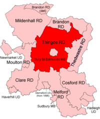 Location within West Suffolk, 1894 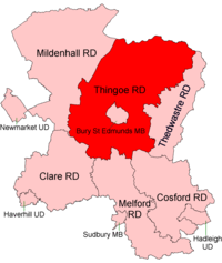 Location within West Suffolk, 1935 | |
| History | |
| • Created | 1894 |
| • Abolished | 1974 |
| • Succeeded by | St Edmundsbury Borough |
| Status | Rural district |
| • HQ | Bury St Edmunds |
It was named after the ancient Hundred of Thingoe ("thing-hoe" - "assembly-mound") and administered from Bury St Edmunds, which it surrounded.
Since 1 April 1974 it has formed part of the Borough of St Edmundsbury.
At the time of its dissolution it consisted of the following 58 civil parishes.
Statistics
| Year | Area[2] | Population [3] |
Density (pop/ha) | |
|---|---|---|---|---|
| acres | ha | |||
| 1911 | 83,998 | 33,993 | 14,439 | 0.42 |
| 1921 | 13,397 | 0.39 | ||
| 1931 | 12,878 | 0.38 | ||
| 1951 | 106,739 | 43,196 | 17,266 | 0.40 |
| 1961 | 106,738 | 20,021 | 0.46 | |
References
- "Thingoe RD through time: Census tables with data for the Local Government District". A Vision of Britain through Time. GB Historical GIS / University of Portsmouth. Retrieved 8 July 2017.
- "Thingoe RD through time: Population Statistics: Area (acres)". A Vision of Britain through Time. GB Historical GIS / University of Portsmouth. Retrieved 8 July 2017.
- "Thingoe RD through time: Population Statistics: Total Population". A Vision of Britain through Time. GB Historical GIS / University of Portsmouth. Retrieved 8 July 2017.