Tharrawaddy, Myanmar
Tharrawaddy (Burmese: သာယာဝတီ) is a city in Bago Region of lower Myanmar. It is the administrative seat of Tharrawaddy District and Tharrawaddy Township. It locates on the main Yangon-Pyay road and 76 miles away at the north of Yangon. The current city was built when under British rule, at that place. In the first British temporary seat at Thonze. However, Thonze is populated for district offices. Therefore, they decided to move two miles north of Thonze and the new district city was built in 1878. The name of the city called Tharyarwaddy as the Burmese old time name.
Tharrawaddy သာယာဝတီ Tharyarwaddy | |
|---|---|
City | |
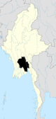
 Tharrawaddy Location in Myanmar | |
| Coordinates: 17°39′06″N 95°47′08″E | |
| Country | |
| Region | |
| District | Tharrawaddy |
| Township | Tharrawaddy |
| Population (151,104) | |
| • City | 151,104 |
| • Urban | 35,815 |
| Time zone | UTC+6.30 (MST) |
Climate
| Climate data for Tharrawaddy, Myanmar (1981–2010) | |||||||||||||
|---|---|---|---|---|---|---|---|---|---|---|---|---|---|
| Month | Jan | Feb | Mar | Apr | May | Jun | Jul | Aug | Sep | Oct | Nov | Dec | Year |
| Average high °C (°F) | 32.1 (89.8) |
34.9 (94.8) |
37.6 (99.7) |
39.3 (102.7) |
35.8 (96.4) |
31.2 (88.2) |
30.5 (86.9) |
30.4 (86.7) |
31.4 (88.5) |
32.5 (90.5) |
32.3 (90.1) |
31.3 (88.3) |
33.3 (91.9) |
| Average low °C (°F) | 13.3 (55.9) |
14.8 (58.6) |
17.9 (64.2) |
21.8 (71.2) |
23.1 (73.6) |
23.0 (73.4) |
22.7 (72.9) |
22.8 (73.0) |
22.7 (72.9) |
22.3 (72.1) |
19.4 (66.9) |
15.5 (59.9) |
19.9 (67.8) |
| Average rainfall mm (inches) | 0.9 (0.04) |
3.0 (0.12) |
3.5 (0.14) |
24.2 (0.95) |
212.8 (8.38) |
485.5 (19.11) |
516.1 (20.32) |
448.2 (17.65) |
318.2 (12.53) |
154.0 (6.06) |
60.6 (2.39) |
0.9 (0.04) |
2,227.9 (87.71) |
| Source: Norwegian Meteorological Institute[1] | |||||||||||||
References
- "Myanmar Climate Report" (PDF). Norwegian Meteorological Institute. pp. 23–36. Archived from the original (PDF) on 8 October 2018. Retrieved 30 November 2018.
Capital: Tharrawaddy | |
|
Capital: Bago | ||||||
| East Bago Region |
|   | ||||
| West Bago Region |
| |||||
| Main cities and towns | ||||||
This article is issued from Wikipedia. The text is licensed under Creative Commons - Attribution - Sharealike. Additional terms may apply for the media files.