Thanon Tok
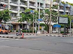
Thanon Tok (Thai: ถนนตก, pronounced [tʰā.nǒn tòk]) is a road junction in the Bang Kho Laem Subdistrict, Bang Kho Laem District, Bangkok. It is a crossroad of Charoen Krung, Rama III and Mahaisawan Roads. It is considered as the last intersection of Charoen Krung.
The name "Thanon Tok" means "road to fall", because it's the end of Charoen Krung Road straight to south and ends at the Chao Phraya River. So, people referred to this road unofficially as "Thanon Tok". Originally, it was a busy pier named "Thanon Tok Pier". Later, water transport decreased significantly and it became a freight-only pier.[1]
Government facilities in the area include Charoenkrung Pracharak Hospital, a public hospital under the Bangkok Metropolitan Administration (BMA) and the Yan Nawa office of the Metropolitan Electricity Authority (MEA), where one of Bangkok's former trams is preserved as a tourist attraction. The Bang Kho Laem Line of the Bangkok trams terminated here at Thanon Tok.[1]
Bangkok Mass Transit Authority (BMTA) bus line 1 is the only route that runs all the length of Charoen Krung from Thanon Tok to Tha Tian in Phra Nakhon District, the distance is 12 kilometers (about 7 mi).[2][3]
At the southern end of Charoen Krung Road until Thanon Tok there is a large community of Muslims. There are many mosques such as Masjid Darul Abideen, Masjid Al Bayaan, Masjid Bang Uthit, Masjid Assalafiyah etc.
References
- "Check in ถิ่นสยาม ถนนตก ทำไมจึงชื่อถนนตก แล้วถนนตกนี้จะไปตกที่ไหน(ชมคลิป)". Matichon (in Thai). 2015-07-06. Retrieved 2018-01-23.
- "Bangkok Bus Line: 1". transitbangkok.
- "แฟนพันธุ์แท้ 2002 : ขสมก". Fan Pan Tae (in Thai). 2002-08-02.