Tha Chang District, Sing Buri
Tha Chang (Thai: ท่าช้าง, pronounced [tʰâː t͡ɕʰáːŋ]) is a district (amphoe) in the southern part of Sing Buri Province, central Thailand.
Tha Chang ท่าช้าง | |
|---|---|
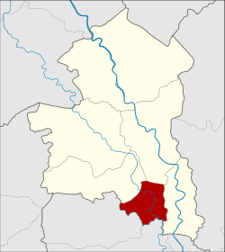 Amphoe location in Sing Buri Province | |
| Coordinates: 14°45′42″N 100°23′24″E | |
| Country | |
| Province | Sing Buri |
| Seat | Thon Samo |
| Area | |
| • Total | 34.4 km2 (13.3 sq mi) |
| Population (2007) | |
| • Total | 16,257 |
| • Density | 472.6/km2 (1,224/sq mi) |
| Time zone | UTC+7 (THA) |
| Postal code | 16140 |
| Geocode | 1705 |
History
Three tambons of Phrom Buri district were separated to create the minor district (king amphoe) Tha Chang in 1960.[1] It was upgraded to a full district in 1963.[2]
Geography
The Noi river is the main water resource of the district. It is a fertile river and has a wide river sand beach. The area was previously used to feed royal elephants.
Neighboring districts are (from the west clockwise) Khai Bang Rachan, Mueang Sing Buri and Phrom Buri of Sing Buri Province, and Chaiyo and Pho Thong of Ang Thong Province.
Administration
The district is subdivided into 4 subdistricts (tambon), which are further subdivided into 23 villages (muban). Thon Samo is a subdistrict municipality (thesaban tambon) which covers most of the tambon Thon Samo and Phikun Thong. There are further 2 Tambon administrative organizations (TAO).
| No. | Name | Thai | Inh. |
|---|---|---|---|
| 1. | Thon Samo | ถอนสมอ | 6,400 |
| 2. | Pho Prachak | โพประจักษ์ | 3,572 |
| 3. | Wihan Khao | วิหารขาว | 1,997 |
| 4. | Phikun Thong | พิกุลทอง | 3,207 |
References
- ประกาศกระทรวงมหาดไทย เรื่อง ยกฐานะตำบลขึ้นเป็นกิ่งอำเภอ (PDF). Royal Gazette (in Thai). 77 (108 ง): 2562. December 27, 1960.
- พระราชกฤษฎีกาตั้งอำเภอบ่อพลอย อำเภอไทรโยค อำเภอหนองเรือ อำเภอหนองสองห้อง อำเภอประทาย อำเภอห้วยแถลง อำเภอละหานทราย อำเภอกุยบุรี อำเภอตาพระยา อำเภอหนองไผ่ อำเภอนาเชือก อำเภอวัดเพลง อำเภอพนัสนิคม อำเภอภูกระดึง อำเภอปรางค์กู่ อำเภอท่าช้าง อำเภอบ้านด่านลานหอย อำเภอบ้านดง อำเภอสว่างอารมณ์ และอำเภอกุดชุม พ.ศ. ๒๕๐๖ (PDF). Royal Gazette (in Thai). 80 (72 ก): 362. July 16, 1963.