Texas State Highway 80
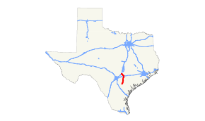
State Highway 80 (SH 80) is a state highway in the U.S. state of Texas that runs 86 miles (138 km) from Karnes City to San Marcos.[1]
| ||||
|---|---|---|---|---|
 | ||||
| Route information | ||||
| Maintained by TxDOT | ||||
| Length | 86.312 mi[1] (138.906 km) | |||
| Existed | 1923–present | |||
| Major junctions | ||||
| South end | ||||
| ||||
| North end | ||||
| Highway system | ||||
| ||||

History
The original highway was designated on August 21, 1923 from San Marcos to Luling, replacing most of SH 29A (the rest of SH 29A was cancelled).[2] On October 12, 1925, SH 80 extended to Wimberley, but this did not take effect until January 1, 1926.[3] On April 6, 1932, SH 80 had a planned extension south to Nixon designated.[4] On July 17, 1934, it was rerouted to end in Refugio over part of SH 29.[5] This change was undone on January 19, 1935.[6] On September 22, 1936, SH 80 extended to Karnes City, replacing a portion of SH 112.[7] On September 26, 1939, SH 80 extended southwest to the Atascosa/Karnes County Line, replacing SH 312.[8] On February 20, 1940, the section from Karnes City to the Atascosa/Karnes County Line was cancelled. On March 26, 1942, the section from Wimberley to San Marcos was transferred to Ranch to Market Road 12. On December 4, 1952, SH 80 extended over old US 181 to new US 181. On June 21, 1990, this extension was cancelled, as it became part of Business US 181. On June 24, 2010, RM 12 was shifted to an alignment south of San Marcos, and the SH 80 designation was extended through the city to a terminus with RM 12 west of the city. On January 26, 2017, the section of SH 80 from RM 12 to Loop 82 was removed from the state highway system and was given to the city of San Marcos.[1][9][10]
Major intersections
| County | Location | mi | km | Destinations | Notes | |||
|---|---|---|---|---|---|---|---|---|
| Karnes | Karnes City | 0.0– 1.5 | 0.0– 2.4 | Southern terminus; south end of SH 123 concurrency | ||||
| 2.1 | 3.4 | North end of SH 123 concurrency | ||||||
| | 6.8 | 10.9 | ||||||
| Helena | 8.2 | 13.2 | ||||||
| | 11.9 | 19.2 | ||||||
| | 15.1 | 24.3 | ||||||
| Gillett | 20.7 | 33.3 | ||||||
| 20.9 | 33.6 | |||||||
| Wilson |
No major junctions | |||||||
| Gonzales | Nixon | 31.1 | 50.1 | South end of SH 97 concurrency | ||||
| 31.2 | 50.2 | |||||||
| Leesville | 33.2 | 53.4 | ||||||
| 35.2 | 56.6 | North end of SH 97 concurrency | ||||||
| 45.9 | 73.9 | |||||||
| 52.8 | 85.0 | |||||||
| Belmont | 52.8 | 85.0 | ||||||
| 55.0 | 88.5 | |||||||
| Guadalupe | | 63.8 | 102.7 | |||||
| Luling | 65.0– 65.1 | 104.6– 104.8 | I-10 exit 628. | |||||
| Caldwell | 67.3 | 108.3 | South end of US 183 concurrency | |||||
| 67.5 | 108.6 | North end of US 183 concurrency | ||||||
| Stairtown | 73.0 | 117.5 | ||||||
| Fentress | 77.0 | 123.9 | ||||||
| | 78.9– 79.0 | 127.0– 127.1 | ||||||
| | 80.6 | 129.7 | ||||||
| | 84.0 | 135.2 | ||||||
| Martindale | 84.3 | 135.7 | South end of SH 142 concurrency | |||||
| 86.4 | 139.0 | |||||||
| Hays | San Marcos | 88.9 | 143.1 | South end of SH 21 concurrency | ||||
| 89.8– 90.0 | 144.5– 144.8 | I-35 exit 205; north end of SH 21/SH 142 concurrency. | ||||||
| 91.2 | 146.8 | |||||||
| 91.2 | 146.8 | |||||||
| 91.5 | 147.3 | |||||||
| | 93.3 | 150.2 | Northern terminus | |||||
1.000 mi = 1.609 km; 1.000 km = 0.621 mi
| ||||||||
References
- Transportation Planning and Programming Division (n.d.). "State Highway No. 80". Highway Designation Files. Texas Department of Transportation. Retrieved August 27, 2013.
- (PDF) https://publicdocs.txdot.gov/minord/MinuteOrderDocLib/003676878.pdf. Missing or empty
|title=(help) - (PDF) https://publicdocs.txdot.gov/minord/MinuteOrderDocLib/003676915.pdf. Missing or empty
|title=(help) - (PDF) https://publicdocs.txdot.gov/minord/MinuteOrderDocLib/003673812.pdf. Missing or empty
|title=(help) - (PDF) https://publicdocs.txdot.gov/minord/MinuteOrderDocLib/003673853.pdf. Missing or empty
|title=(help) - (PDF) https://publicdocs.txdot.gov/minord/MinuteOrderDocLib/003673862.pdf. Missing or empty
|title=(help) - (PDF) https://publicdocs.txdot.gov/minord/MinuteOrderDocLib/003673887.pdf. Missing or empty
|title=(help) - (PDF) https://publicdocs.txdot.gov/minord/MinuteOrderDocLib/003676258.pdf. Missing or empty
|title=(help) - Transportation Planning and Programming Division (2012). Texas County Mapbook (PDF) (Map) (2012 ed.). 1:120,000. Texas Department of Transportation. p. 433. OCLC 867856197. Retrieved August 27, 2013.
- (PDF) http://ftp.dot.state.tx.us/pub/txdot/commission/2017/0126/14b4.pdf. Missing or empty
|title=(help)