Texas State Highway 62
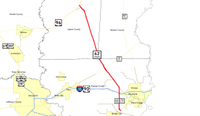
State Highway 62 or SH 62 is a highway located in southeastern Texas. It runs 29.249 miles (47.072 km) from SH 73/SH 87 near Orange to an intersection with U.S. Highway 96 (US 96), Business U.S. Highway 96 (US 96 Bus), and Farm to Market Road 1004 (FM 1004) in Buna. SH 62 was established in 1923, and its southern end was extended from US 90 to SH 73/SH 87 in 1962.
| ||||
|---|---|---|---|---|
 | ||||
| Route information | ||||
| Maintained by TxDOT | ||||
| Length | 29.249 mi[1] (47.072 km) | |||
| Existed | 1923–present | |||
| Major junctions | ||||
| South end | ||||
| North end | ||||
| Location | ||||
| Counties | Orange, Newton, Jasper | |||
| Highway system | ||||
| ||||

Route description
SH 62 begins at SH 73 and SH 87 between Orange and Bridge City. SH 73 is concurrent with SH 62 from the southern terminus to the intersection with Interstate 10 (I‑10) and US 90, where SH 73 ends. SH 62 continues its northward journey past this point, going through Mauriceville and Texla in Orange County, clipping the extreme southwest corner of Newton County, and, in Jasper County, traveling through the small community of Gist and ending at Buna.
History
This route was designated on August 21, 1923, but with its south end at SH 3 (later US 90), replacing SH 8B.[2] On May 1, 1962, FM 406 between US 90 and SH 73 was canceled and combined with SH 62.[1]
Major intersections
| County | Location | mi[3] | km | Destinations | Notes | |||
|---|---|---|---|---|---|---|---|---|
| Orange | | 29.154 | 46.919 | South end of SH 73 overlap; SH 73 west continues concurrently with SH 87 south | ||||
| | 27.047 | 43.528 | ||||||
| Orange | 24.571– 24.513 | 39.543– 39.450 | I-10 exit 873; north end of SH 73 concurrency; east end of SH 73 | |||||
| 23.221 | 37.371 | |||||||
| Mauriceville | 17.568 | 28.273 | Interchange | |||||
| 17.323– 17.207 | 27.879– 27.692 | |||||||
| Texla | 16.261 | 26.170 | ||||||
| Newton |
No major junctions | |||||||
| Jasper | | 8.499 | 13.678 | |||||
| | 4.123 | 6.635 | ||||||
| | 2.217 | 3.568 | ||||||
| Buna | 0.971 | 1.563 | ||||||
| 0.653 | 1.051 | South end of unsigned US 96 Business overlap | ||||||
| 0.000 | 0.000 | North end of unsigned US 96 Business overlap | ||||||
1.000 mi = 1.609 km; 1.000 km = 0.621 mi
| ||||||||
References
- Transportation Planning and Programming Division (n.d.). "State Highway No. 62". Highway Designation Files. Texas Department of Transportation. Retrieved July 21, 2018.
- Texas Highway Department (August 21, 1923). "Minutes of the Seventy-Third and First Adjourned Meeting of the State Highway Commission" (PDF). Texas Department of Transportation. Retrieved October 5, 2019.
- Texas Department of Transportation (2018). "Statewide Planning Map LRS Readout (ArcGIS)". Retrieved October 4, 2019.