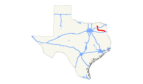
Texas State Highway 154
State Highway 154 or SH 154 is a state highway that runs from Cooper to Marshall in northeast Texas.
| ||||
|---|---|---|---|---|
 | ||||
| Route information | ||||
| Maintained by TxDOT | ||||
| Length | 104.59 mi[1][lower-alpha 1] (168.32 km) | |||
| Existed | by 1931–present | |||
| Major junctions | ||||
| Northwest end | ||||
| Southeast end | ||||
| Highway system | ||||
| ||||

.jpg)
History
The route was designated originally on March 19, 1930 between Cooper and Quitman as a renumbering of SH 37A. A proposed extension west to Ladonia was added on February 8, 1933.[2] On July 15, 1935, the extension was cancelled.[3] On December 22, 1936, the extension of SH 154 to Ladonia was restored.[4] On August 4, 1937, this section to Cooper was renumbered as new SH 247, and SH 154 was rerouted north over old SH 247 to northeast of Cooper.[5] On November 16, 1937, SH 154 extended to Gilmer.[6] On September 26, 1939, it was extended southeast from Gilmer to Marshall along its current route. This extension replaced part of SH 155.[7] On August 24, 1960, the section north of Sulphur Springs was transferred to SH 19. On August 28, 1961, SH 154 was extended north and west to Cooper, replacing part of FM 64.[8] On January 31, 1969, SH 154 extended southeast from US 80 to SH 43, concurrent with SH 43 to US 59, east to FM 31 and southeast concurrent with FM 31 to I-20. On November 16, 1987, SH 154 was rerouted through Sulphur Springs. On January 28, 2005, the section of SH 154 from US 59 to FM 31 was cancelled as it was never built, and the concurrent portions were removed, with the section of SH 154 south of Loop 390 to SH 43 becoming part of Loop 390.[9]
Junction list
| County | Location | mi | km | Destinations | Notes |
|---|---|---|---|---|---|
| Delta | Cooper | 0.0 | 0.0 | ||
| 0.4 | 0.64 | ||||
| 1.1 | 1.8 | ||||
| | 2.5 | 4.0 | |||
| Delta–Hopkins county line | | 5.9 | 9.5 | West end of SH 19 overlap | |
| Hopkins | Tira | 9.1 | 14.6 | ||
| | 12.7 | 20.4 | |||
| | 18.0 | 29.0 | |||
| Sulphur Springs | 19.4 | 31.2 | East end of SH 19 overlap | ||
| 20.8 | 33.5 | ||||
| 22.0 | 35.4 | West end of Bus. US 67 overlap | |||
| 22.1 | 35.6 | East end of Bus. 67 overlap | |||
| 23.6 | 38.0 | I-30 exit 124 | |||
| 24.2 | 38.9 | ||||
| | 31.9 | 51.3 | West end of FM 1567 overlap | ||
| Seymore | 32.5 | 52.3 | East end of FM 1567 overlap | ||
| Wood | Yantis | 36.9 | 59.4 | ||
| | 39.4 | 63.4 | |||
| | 43.9 | 70.7 | |||
| | 47.6 | 76.6 | |||
| Quitman | 49.1 | 79.0 | West end of SH 37 overlap | ||
| 49.2 | 79.2 | ||||
| 49.5 | 79.7 | East end of SH 37 overlap | |||
| | 55.5 | 89.3 | |||
| | 60.6 | 97.5 | |||
| | 64.9 | 104.4 | |||
| Upshur | Rhonesboro | 67.7 | 109.0 | ||
| | 77.8 | 125.2 | |||
| Gilmer | 78.3 | 126.0 | |||
| 79.5 | 127.9 | ||||
| | 81.5 | 131.2 | |||
| | 83.7 | 134.7 | |||
| | 87.2 | 140.3 | West end of FM 726 overlap | ||
| | 88.1 | 141.8 | East end of FM 726 overlap | ||
| Diana | 91.1 | 146.6 | |||
| | 93.3 | 150.2 | |||
| | 97.0 | 156.1 | |||
| Harrison | | 102.3 | 164.6 | West end of FM 450 overlap | |
| Harleton | 102.6 | 165.1 | East end of FM 450 overlap | ||
| | 104.0 | 167.4 | |||
| Marshall | 116.4 | 187.3 | |||
1.000 mi = 1.609 km; 1.000 km = 0.621 mi
| |||||
Notes
- The certified mileage given is shorter than the actual mileage as TxDOT considers SH 154 to be discontinuous at rather than concurrent with SH 19 and SH 37.
References
- Transportation Planning and Programming Division (n.d.). "State Highway No. 154". Highway Designation Files. Texas Department of Transportation. Retrieved 2010-06-15.
- (PDF) https://publicdocs.txdot.gov/minord/MinuteOrderDocLib/003673825.pdf. Missing or empty
|title=(help) - (PDF) https://publicdocs.txdot.gov/minord/MinuteOrderDocLib/003673871.pdf. Missing or empty
|title=(help) - (PDF) https://publicdocs.txdot.gov/minord/MinuteOrderDocLib/003673889.pdf. Missing or empty
|title=(help) - (PDF) https://publicdocs.txdot.gov/minord/MinuteOrderDocLib/003673901.pdf. Missing or empty
|title=(help) - (PDF) https://publicdocs.txdot.gov/minord/MinuteOrderDocLib/003673908.pdf. Missing or empty
|title=(help) - "Marshall-Gilmer Highway Number Changed to 154". The Marshall News Messenger. March 8, 1940. p. 8. Retrieved September 17, 2017 – via Newspapers.com.

- Transportation Planning and Programming Division (n.d.). "Farm to Market Road No. 64". Highway Designation Files. Texas Department of Transportation. Retrieved November 6, 2017.
- Transportation Planning and Programming Division (n.d.). "State Highway Loop No. 390". Highway Designation Files. Texas Department of Transportation. Retrieved November 6, 2017.