Texas State Highway 131
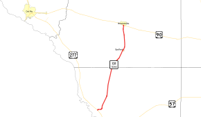
State Highway 131 (SH 131) is a Texas state highway that runs from US 277 near Eagle Pass to US 90 in Brackettville.[1]
| ||||
|---|---|---|---|---|
 | ||||
| Route information | ||||
| Maintained by TxDOT | ||||
| Length | 33.092 mi[1] (53.256 km) | |||
| Existed | by 1928–present | |||
| Major junctions | ||||
| South end | ||||
| North end | ||||
| Location | ||||
| Counties | Maverick, Kinney | |||
| Highway system | ||||
| ||||

Route description
SH 131 begins at US 277 north of Eagle Pass, near Maverick County Memorial International Airport.[2] The route travels roughly to the north-northeast through unincorporated sections of Maverick and Kinney counties; the only incorporated community between the route's termini is the city of Spofford. The highway ends in Brackettville at a junction with US 90.[3]
History
SH 131 was originally designated on January 18, 1928 from Brackettville to Spofford.[4] The extension south was added on January 18, 1935.[5] On July 15, 1935, the extension south of Spofford was cancelled.[6] The extension south of Spofford was restored on November 24, 1936.[7][1]
Major intersections
| County | Location | mi[8] | km | Destinations | Notes |
|---|---|---|---|---|---|
| Maverick | | 0.0 | 0.0 | Southern terminus | |
| Kinney | | 21.7 | 34.9 | ||
| Spofford | 23.8 | 38.3 | |||
| Brackettville | 33.1 | 53.3 | Northern terminus | ||
| 1.000 mi = 1.609 km; 1.000 km = 0.621 mi | |||||
References
- Transportation Planning and Programming Division (n.d.). "State Highway No. 131". Highway Designation Files. Texas Department of Transportation. Retrieved June 15, 2010.
- Transportation Planning and Programming Division (2012). Texas County Mapbook (PDF) (Map) (2012 ed.). 1:120,000. Texas Department of Transportation. p. 289. OCLC 867856197. Retrieved February 1, 2014.
- Transportation Planning and Programming Division (2012). Texas County Mapbook (PDF) (Map) (2012 ed.). 1:120,000. Texas Department of Transportation. p. 288. OCLC 867856197. Retrieved February 1, 2014.
- (PDF) https://publicdocs.txdot.gov/minord/MinuteOrderDocLib/003676986.pdf. Missing or empty
|title=(help) - (PDF) https://publicdocs.txdot.gov/minord/MinuteOrderDocLib/003673862.pdf. Missing or empty
|title=(help) - (PDF) https://publicdocs.txdot.gov/minord/MinuteOrderDocLib/003673871.pdf. Missing or empty
|title=(help) - (PDF) https://publicdocs.txdot.gov/minord/MinuteOrderDocLib/003673888.pdf. Missing or empty
|title=(help) - Google (January 25, 2014). "Texas State Highway 131" (Map). Google Maps. Google. Retrieved January 25, 2014.