Mount Tendürek
Tendürek (Turkish: Tendürek Dağı, Armenian: Թոնդրակ, Tondrak) is a shield volcano located in the Ağrı and Van provinces of eastern Turkey, close to the borders with Iran. The elongated volcano rises 1,800 m (5,906 ft) above the Doğubeyazıt plain, south of Mount Ararat. Two main cones with a crater each and several minor lateral cones form the edifice. The edifice dates 700,000–500,000 years BP to 13,000 BP and is mostly constructed from basaltic lavas, with some pyroclastics and trachytic/trachyandesitic lavas. It has a volume of more than 300 km3 and covers a surface area of about 650 km2. Pyroclastic cones with basaltic lava flows on the eastern side of the mountain are around 2,500 years old. The last known eruption may have been a gas and ash eruption in 1855, and hydrothermal systems exist on the volcano. Since 1993, the volcano has been subsiding in a ring fault. The Armenian name for the mountain was Tondrak - the medieval Armenian Tondrakite Movement of the 950s, which based its ideology on Paulician teaching.
| Tendürek | |
|---|---|
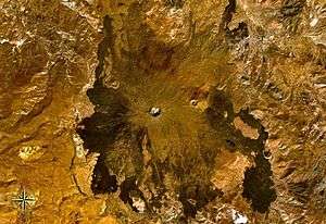 Tendürek seen from space | |
| Highest point | |
| Elevation | 3,584 m (11,759 ft) |
| Coordinates | 39.37°N 43.87°E |
| Geography | |
| Location | Ağrı and Van provinces, Turkey |
| Parent range | Armenian Highlands |
| Geology | |
| Mountain type | Shield volcano |
| Last eruption | 1855 |
See also
References
- Tendürek Dagi, Global Volcanism Program
- An active ring fault detected at Tendürek volcano by using InSAR, Journal of Geophysical Research.
- Geology of the quaternary volcanic centres of the east Anatolia, Journal of Volcanology and Geothermal Research.
- Annäherung an Armenien: Geschichte und Gegenwart, Tessa Hofmann, Tessa Savvidis.
| Mountain ranges | |
|---|---|
| Mountains |
|