Tell, Nablus
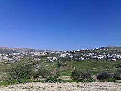
Tell (Arabic: تلّ) is a Palestinian town in the Nablus Governorate in northern West Bank, located five kilometers southwest of Nablus. According to the Palestinian Central Bureau of Statistics (PCBS), the town had a population of 4,334 inhabitants in 2007.[2] Most of the town's laborers work in agriculture, with figs and olives being the major source of income.[3]
Tell | |
|---|---|
| Arabic transcription(s) | |
| • Arabic | تلّ |
| • Latin | Tel (official) Tall (unofficial) |
 Tell | |
 Tell Location of Tell within Palestine 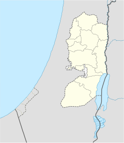 Tell Tell (the West Bank) | |
| Coordinates: 32°12′03″N 35°12′47″E | |
| Palestine grid | 170/178 |
| State | State of Palestine |
| Governorate | Nablus |
| Government | |
| • Type | Village council |
| • Head of Municipality | Omar Abdel Latif Eshtaia |
| Area | |
| • Total | 13,776 dunams (13.8 km2 or 5.3 sq mi) |
| Population (2007) | |
| • Total | 4,334 |
| • Density | 310/km2 (810/sq mi) |
| Name meaning | "Mound"[1] |
Mohammad Shtayyeh, a Palestinian economist and politician, was born in Tell.
History
Ceramics from the Byzantine era have been found here.[4]
Ottoman era
In 1517, the village was included in the Ottoman empire with the rest of Palestine, and it appeared in the 1596 tax-records as Till, located in the Nahiya of Jabal Qubal of the Liwa of Nablus. The population was 46 households, all Muslim. They paid a fixed tax rate of 33.3% on agricultural products, such as wheat, barley, summer crops, olive trees, goats and beehives, in addition to occasional revenues, a press for olive oil or grape syrup, and a fixed tax for people of Nablus area; a total of 5,100 akçe.[5]
In 1838, Till was located in the District of Jurat 'Amra, south of Nablus.[6]
In 1863, Victor Guérin found it to have a population of one thousand inhabitants. It was divided into several districts, each administered by a different sheikh. He further noted: "Some houses are large and fairly well built. Around the village grow, in pens, beautiful plantations of fig and pomegranate trees."[7]
In 1882, the PEF's Survey of Western Palestine described Till as: "A village of moderate size on low ground, with a high mound behind it on the south; it has a well and a few trees, and on the west a pool in winter; the hills to the north are bare and white, but terraced to the very top."[8]
British mandate era
In the 1922 census of Palestine conducted by the British Mandate authorities, Tel had a population of 567 Muslims,[9] increasing in the 1931 census to 803 Muslims, in 209 houses.[10]
In the 1945 statistics the population was 1,060 Muslims,[11] while the total land area was 13,766 dunams, according to an official land and population survey.[12] Of this, 1,056 dunams were for plantations and irrigable land, 7,023 for cereals,[13] while 55 dunams were classified as built-up areas.[14]
Jordanian era
In the wake of the 1948 Arab–Israeli War, and after the 1949 Armistice Agreements, Tell came under Jordanian rule.
The Jordanian census of 1961 found 1,539 inhabitants.[15]
1967, aftermath
Since the Six-Day War in 1967, Tell has been held under Israeli occupation.
References
- Palmer, 1881, p. 194
- 2007 PCBS Census. Palestinian Central Bureau of Statistics. p.110.
- Israeli Forces Storm Tel village In Nablus Governorate Archived 2011-05-19 at the Wayback Machine Land Research Center. 2001-12-20
- Dauphin, 1998, p. 798
- Hütteroth and Abdulfattah, 1977, p. 134
- Robinson and Smith, 1841, vol 3, Appendix 2, p. 127
- Guérin, 1875, p. 178
- Conder and Kitchener, 1882, SWP II, p. 164
- Barron, 1923, Table IX, p. 24
- Mills, 1932, p. 65
- Government of Palestine, Department of Statistics, 1945, p. 19
- Government of Palestine, Department of Statistics. Village Statistics, April, 1945. Quoted in Hadawi, 1970, p. 61
- Government of Palestine, Department of Statistics. Village Statistics, April, 1945. Quoted in Hadawi, 1970, p. 108
- Government of Palestine, Department of Statistics. Village Statistics, April, 1945. Quoted in Hadawi, 1970, p. 158
- Government of Jordan, Department of Statistics, 1964, p. 24
Bibliography
- Barron, J.B., ed. (1923). Palestine: Report and General Abstracts of the Census of 1922. Government of Palestine.
- Conder, C.R.; Kitchener, H.H. (1882). The Survey of Western Palestine: Memoirs of the Topography, Orography, Hydrography, and Archaeology. 2. London: Committee of the Palestine Exploration Fund.
- Dauphin, Claudine (1998). La Palestine byzantine, Peuplement et Populations. BAR International Series 726 (in French). III : Catalogue. Oxford: Archeopress. ISBN 0-860549-05-4.
- Government of Jordan, Department of Statistics (1964). First Census of Population and Housing. Volume I: Final Tables; General Characteristics of the Population (PDF).
- Government of Palestine, Department of Statistics (1945). Village Statistics, April, 1945.
- Guérin, V. (1875). Description Géographique Historique et Archéologique de la Palestine (in French). 2: Samarie, pt. 2. Paris: L'Imprimerie Nationale.
- Hadawi, S. (1970). Village Statistics of 1945: A Classification of Land and Area ownership in Palestine. Palestine Liberation Organization Research Center.
- Hütteroth, Wolf-Dieter; Abdulfattah, Kamal (1977). Historical Geography of Palestine, Transjordan and Southern Syria in the Late 16th Century. Erlanger Geographische Arbeiten, Sonderband 5. Erlangen, Germany: Vorstand der Fränkischen Geographischen Gesellschaft. ISBN 3-920405-41-2.
- Mills, E., ed. (1932). Census of Palestine 1931. Population of Villages, Towns and Administrative Areas. Jerusalem: Government of Palestine.
- Palmer, E.H. (1881). The Survey of Western Palestine: Arabic and English Name Lists Collected During the Survey by Lieutenants Conder and Kitchener, R. E. Transliterated and Explained by E.H. Palmer. Committee of the Palestine Exploration Fund.
- Robinson, E.; Smith, E. (1841). Biblical Researches in Palestine, Mount Sinai and Arabia Petraea: A Journal of Travels in the year 1838. 3. Boston: Crocker & Brewster.
External links
- Welcome to Tall
- Survey of Western Palestine, Map 11: IAA, Wikimedia commons
- Tell, aerial photo, Applied Research Institute–Jerusalem (ARIJ)
| Cities |
|  |
|---|---|---|
| Municipalities | ||
| Villages |
| |
| Refugee camps | ||