Tegua
Tegua is an island in Vanuatu's Torres Islands chain, located in Torba Province.
Tegua | |
|---|---|
 Location of Tegua in Torres Islands | |
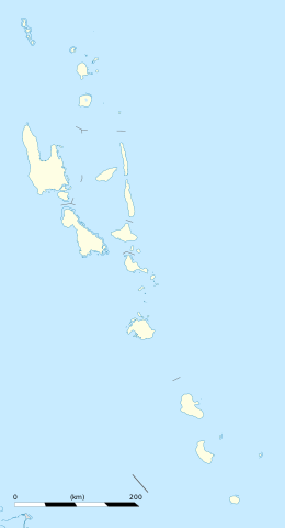 Tegua Location in Vanuatu | |
| Coordinates: 13°14′47″S 166°37′33″E | |
| Country | |
| Province | Torba Province |
| Area | |
| • Total | 30.8 km2 (11.9 sq mi) |
| [1] | |
| Population (2009) | |
| • Total | 58 |
| • Density | 1.9/km2 (4.9/sq mi) |
| Time zone | UTC+11 (VUT) |
Geography
The island spans 7 km by 6.5 km; on the eastern side of the island is Lateu Bay indented 1.8 km. Ngwel Island is located 600 meters off the west coast of Tegua Island.[2]
Population
The only village is Lateu, with a population of 58.[3] About 100 residents of Tegua were evacuated by the government because rising sea levels were flooding their island.
One geological study found that of four islands in the group, Tegua had the slowest inferred uplift rate at 0.7 mm/yr for southeastern Tegua. A "narrow E-W trending block has been down-dropped relative to the rest of the isle.
References
- "Vanuatu". Haos Blong Volkeno. Retrieved 8 August 2018.
- Seech, John. "Tegua Island, Vanuatu - John Seach". Vanuatu Travel. Retrieved 5 August 2018.
-
"2009 National Census of Population and Housing: Summary Release" (PDF). Vanuatu National Statistics Office. 2009. Retrieved October 11, 2010. Cite journal requires
|journal=(help)
This article is issued from Wikipedia. The text is licensed under Creative Commons - Attribution - Sharealike. Additional terms may apply for the media files.