Taytay, Palawan
Taytay, officially the Municipality of Taytay, (Tagalog: Bayan ng Taytay IPA: [taɪ'taɪ]), is a 1st class municipality in the province of Palawan, Philippines. According to the 2015 census, it has a population of 75,165 people.[3]
Taytay | |
|---|---|
| Municipality of Taytay | |
 | |
 Seal | |
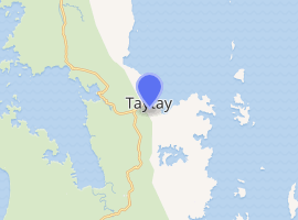
 Map of Palawan with Taytay highlighted | |
| |
.svg.png) Taytay Location within the Philippines | |
| Coordinates: 10°49′N 119°31′E | |
| Country | |
| Region | Mimaropa (Region IV-B) |
| Province | Palawan |
| District | 1st district |
| Founded | 1623 |
| Barangays | 31 (see Barangays) |
| Government | |
| • Type | Sangguniang Bayan |
| • Mayor | Romy L. Salvame |
| • Vice Mayor | Christian V. Rodriguez |
| • Congressman | Franz Josef George E. Alvarez |
| • Electorate | 44,387 voters (2019) |
| Area | |
| • Total | 1,257.68 km2 (485.59 sq mi) |
| Elevation | 4.0 m (13.1 ft) |
| Population (2015 census)[3] | |
| • Total | 75,165 |
| • Density | 60/km2 (150/sq mi) |
| • Households | 15,993 |
| Economy | |
| • Income class | 1st municipal income class |
| • Poverty incidence | 27.44% (2015)[4] |
| • Revenue (₱) | 290,366,640.62 (2016) |
| Time zone | UTC+8 (PST) |
| ZIP code | 5312 |
| PSGC | |
| IDD : area code | +63 (0)48 |
| Climate type | tropical climate |
| Native languages | Palawano language Central Tagbanwa Tagalog |
Since 2002, its Cathedral of St. Joseph the Worker is the episcopal see of the pre-diocesan missionary Apostolic Vicariate of Taytay.
History
Before the Spanish colonization, The Kingdom of Taytay was ruled by a monarch noted as followed everywhere at any given time by ten scribes. The crew of Ferdinand Magellan held the Taytay king and queen for ransom after escaping the Battle of Mactan where Magellan was slain. They intended to secure more supplies as they plan to cross into the Moluccas where the Portuguese were so help could be sought. The native king and his subjects complied with the demands and even added more food supplies than what they asked for. This was duly recorded by Antonio Pigafetta, Magellan's chronicler, who was on board in one of the ships when these events took place.
Pigafetta also took note of one curious thing in the kingdom. He found the natives fond of cockfighting, long before this pastime was seen or even heard of in the Western Hemisphere.
During the Spanish colonization of the Philippines, Taytay was formally founded in 1623. Taytay became the capital of the province of Calamianes, the entire territory of Paragua (now Palawan), in 1818; and the province of Castilla, a land area occupying the northern part of Palawan, in 1858.[5]
Archived baptismal records of Cuyo, Palawan show that the last monarch of the Kingdom of Taytay was converted to Christianity and christened Flores de los Santos Cabaylo meaning Cabaylo, Flower of the Saints. No other sovereign royal datu after him ruled in his kingdom. King Cabaylo's descendants include the present clans of Cabaylo-Manlavi-Gabinete-Macolor as main genealogical roots. His Royal Highness Datu Dr. Fernando Macolor Cruz who hailed from the Cabailo-Manlavi-Gabinete-Macolor line of the royal house is the present pretender and sole claimant to the most serene and ancient throne of the Kingdom of Taytay.
During the American era, Taytay ceased being Palawan's capital, and its administrative boundary was reduced by approximately 500,000 hectares upon the creation of the Municipality of El Nido in 1916.[6]
The historic Taytay Fort, the Fuerza de Santa Isabel, built in 1667 under the Augustinian Recollect Fathers and named in honor of Spain's Queen Isabela II in the 19th century, was used as a military station during that period. This famous relic was completed in 1738. It was mainly used to defend against Muslim warrior-raiders in their colorful war boats while the Spanish soldiers fire at them with their huge cannons. The fort's small chapel and cannons are still intact.[7] The fort is now under the supervision of the National Museum. The Moro action must be understood not as an act of piracy but as a showdown of power and challenge to Spanish hegemony over the islands. It can be viewed as the Tausug's efforts to recover what was once theirs. Similar raids were also carried out against Christian converts in Spanish Cuyo, Dumaran, Linapacan and Culion.
In 1957, the Island of Dibangan was constituted into a barrio.[8]
Barangays
Taytay is politically subdivided into 31 barangays.
- Abongan
- Banbanan
- Bantulan
- Batas
- Bato
- Beton
- Busy Bees
- Calawag
- Casian
- Cataban
- Debangan
- Dipla
- Liminangcong
- Maytegued
- New Guinlo
- Old Guinlo
- Pamantolon
- Pancol
- Paly (Paly Island)
- Poblacion
- Pularaquen (Canique)
- San Jose
- Sandoval
- Silanga
- Alacalian
- Baras (Pangpang)
- Libertad
- Minapla
- Talog
- Tumbod
- Paglaum
Demographics
| Population census of Taytay | |||||||||||||||||||||||||||||||||||||||||||||||||
|---|---|---|---|---|---|---|---|---|---|---|---|---|---|---|---|---|---|---|---|---|---|---|---|---|---|---|---|---|---|---|---|---|---|---|---|---|---|---|---|---|---|---|---|---|---|---|---|---|---|
|
| ||||||||||||||||||||||||||||||||||||||||||||||||
| Source: Philippine Statistics Authority[3][12][13][14] | |||||||||||||||||||||||||||||||||||||||||||||||||
In the 2015 census, the population of Taytay, Palawan, was 75,165 people,[3] with a density of 60 inhabitants per square kilometre or 160 inhabitants per square mile.
Climate
| Climate data for Taytay, Palawan | |||||||||||||
|---|---|---|---|---|---|---|---|---|---|---|---|---|---|
| Month | Jan | Feb | Mar | Apr | May | Jun | Jul | Aug | Sep | Oct | Nov | Dec | Year |
| Average high °C (°F) | 29 (84) |
30 (86) |
30 (86) |
31 (88) |
31 (88) |
30 (86) |
29 (84) |
29 (84) |
29 (84) |
29 (84) |
29 (84) |
29 (84) |
30 (85) |
| Average low °C (°F) | 23 (73) |
23 (73) |
23 (73) |
24 (75) |
25 (77) |
25 (77) |
24 (75) |
24 (75) |
24 (75) |
24 (75) |
24 (75) |
24 (75) |
24 (75) |
| Average precipitation mm (inches) | 45 (1.8) |
34 (1.3) |
62 (2.4) |
64 (2.5) |
127 (5.0) |
159 (6.3) |
172 (6.8) |
147 (5.8) |
167 (6.6) |
182 (7.2) |
172 (6.8) |
88 (3.5) |
1,419 (56) |
| Average rainy days | 12.1 | 9.4 | 13.0 | 14.3 | 22.7 | 26.9 | 28.0 | 26.4 | 27.0 | 27.0 | 22.7 | 17.8 | 247.3 |
| Source: Meteoblue [15] | |||||||||||||
Gallery
 Taytay Sign
 Fort Sta. Isabel
 Chapel inside Fort Sta. Isabel
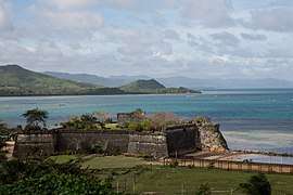 Fortress Sta. Isabel
 Inside the church in the fortress of Santa Isabel
References
- "Municipality". Quezon City, Philippines: Department of the Interior and Local Government. Retrieved 31 May 2013.
- "Province: Palawan". PSGC Interactive. Quezon City, Philippines: Philippine Statistics Authority. Retrieved 12 November 2016.
- Census of Population (2015). "Region IV-B (Mimaropa)". Total Population by Province, City, Municipality and Barangay. PSA. Retrieved 20 June 2016.
- "PSA releases the 2015 Municipal and City Level Poverty Estimates". Quezon City, Philippines. Retrieved 12 October 2019.
- Palawan Tourism Council: History of Palawan. Accessed August 27, 2008.
- El Nido Tourism Office. Accessed August 28, 2008.
- Official Website of the Province of Palawan Archived 2008-08-27 at the Wayback Machine. Accessed August 28, 2008.
- "Republic Act No.1748, June 21, 1957". Supreme Court E-Library. Retrieved April 2, 2016.
- "Republic Act No.1238, June 07, 1955". Supreme Court E-Library. Retrieved April 2, 2016.
- "Republic Act No. 1525, June 16, 1956". Supreme Court E-Library. Retrieved April 2, 2016.
- "Republic Act No. 1526, June 16, 1956". Supreme Court E-Library. Retrieved April 2, 2016.
- Census of Population and Housing (2010). "Region IV-B (Mimaropa)". Total Population by Province, City, Municipality and Barangay. NSO. Retrieved 29 June 2016.
- Censuses of Population (1903–2007). "Region IV-B (Mimaropa)". Table 1. Population Enumerated in Various Censuses by Province/Highly Urbanized City: 1903 to 2007. NSO.
- "Province of Palawan". Municipality Population Data. Local Water Utilities Administration Research Division. Retrieved 17 December 2016.
- "Taytay: Average Temperatures and Rainfall". Meteoblue. Retrieved 17 November 2019.
External links
| Wikimedia Commons has media related to Taytay, Palawan. |
| Wikivoyage has a travel guide for Taytay. |
- Taytay Profile at PhilAtlas.com
- Philippine Standard Geographic Code
- Philippine Census Information
- Local Governance Performance Management System
Places adjacent to Taytay, Palawan | ||||||||||
|---|---|---|---|---|---|---|---|---|---|---|
| ||||||||||
Puerto Princesa (capital) | |
| Municipalities | |
| Highly urbanized city |
|
| Cultural |
| |
|---|---|---|
| Natural | ||