Tatamy, Pennsylvania
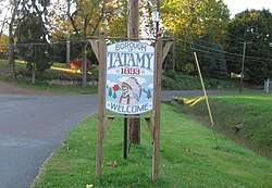
Tatamy is a borough in Northampton County, Pennsylvania, United States. Tatamy is located in the Lehigh Valley region of the state. It is named for Moses Tunda Tatamy.
Borough of Tatamy | |
|---|---|
 | |
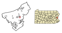 Location of Tatamy in Northampton County, Pennsylvania. | |
 Tatamy Location of Tatamy in Pennsylvania  Tatamy Tatamy (the United States) | |
| Coordinates: 40°44′27″N 75°15′12″W | |
| Country | United States |
| State | Pennsylvania |
| County | Northampton |
| Government | |
| • Mayor | Christopher Moren[1] |
| Area | |
| • Total | 0.57 sq mi (1.47 km2) |
| • Land | 0.56 sq mi (1.44 km2) |
| • Water | 0.01 sq mi (0.03 km2) |
| Elevation | 387 ft (118 m) |
| Population (2010) | |
| • Total | 1,203 |
| • Estimate (2018)[3] | 1,142 |
| • Density | 2,046.85/sq mi (790.65/km2) |
| Time zone | UTC-5 (EST) |
| • Summer (DST) | UTC-4 (EDT) |
| ZIP Code | 18085 |
| Area code(s) | 610 and 484 |
| FIPS code | 42-76144 |
| Website | www |
The population of Tatamy was 1,203 at the 2010 census.
Geography
Tatamy is located at 40°44′27″N 75°15′12″W.[4]
According to the United States Census Bureau, the borough has a total area of 0.5 square miles (1.3 km2), all of it land.
Demographics
| Historical population | |||
|---|---|---|---|
| Census | Pop. | %± | |
| 1900 | 260 | — | |
| 1910 | 512 | 96.9% | |
| 1920 | 478 | −6.6% | |
| 1930 | 592 | 23.8% | |
| 1940 | 604 | 2.0% | |
| 1950 | 681 | 12.7% | |
| 1960 | 762 | 11.9% | |
| 1970 | 891 | 16.9% | |
| 1980 | 910 | 2.1% | |
| 1990 | 873 | −4.1% | |
| 2000 | 930 | 6.5% | |
| 2010 | 1,203 | 29.4% | |
| Est. 2018 | 1,142 | [3] | −5.1% |
| Sources:[5][6][7] | |||
At the 2000 census there were 930 people in 352 households, including 267 families, in the borough. The population density was 1,789.1 people per square mile (690.5/km2). There were 356 housing units at an average density of 684.9 per square mile (264.3/km2). The racial makeup of the borough was 98.49% White, 0.22% African American, 0.32% Native American, 0.11% Asian, 0.43% from other races, and 0.43% from two or more races. Hispanic or Latino of any race were 0.97%.[6]
There were 352 households, 32.4% had children under the age of 18 living with them, 63.6% were married couples living together, 8.2% had a female householder with no husband present, and 24.1% were non-families. 21.0% of households were made up of individuals, and 10.2% were one person aged 65 or older. The average household size was 2.63 and the average family size was 3.03.
The age distribution was 24.8% under the age of 18, 6.0% from 18 to 24, 28.9% from 25 to 44, 28.5% from 45 to 64, and 11.7% 65 or older. The median age was 40 years. For every 100 females there were 91.0 males. For every 100 females age 18 and over, there were 89.4 males.
The median household income was $48,942 and the median family income was $55,750. Males had a median income of $38,333 versus $26,797 for females. The per capita income for the borough was $21,759. About 2.9% of families and 3.8% of the population were below the poverty line, including 6.2% of those under age 18 and 5.0% of those age 65 or over.
Public education
The Borough is served by the Nazareth Area School District.
References
- "Council & Committees". tatamypa.com. 2017. Retrieved January 20, 2018.
- "2017 U.S. Gazetteer Files". United States Census Bureau. Retrieved Mar 24, 2019.
- "Population and Housing Unit Estimates". Retrieved February 9, 2020.
- "US Gazetteer files: 2010, 2000, and 1990". United States Census Bureau. 2011-02-12. Retrieved 2011-04-23.
- "Census of Population and Housing". U.S. Census Bureau. Retrieved 11 December 2013.
- "U.S. Census website". United States Census Bureau. Retrieved 2008-01-31.
- "Incorporated Places and Minor Civil Divisions Datasets: Subcounty Resident Population Estimates: April 1, 2010 to July 1, 2012". Population Estimates. U.S. Census Bureau. Archived from the original on 11 June 2013. Retrieved 11 December 2013.
Municipalities and communities of Northampton County, Pennsylvania, United States | ||
|---|---|---|
| Cities | 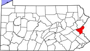 | |
| Boroughs | ||
| Townships | ||
| CDPs | ||
| Unincorporated communities | ||
| Footnotes | ‡This populated place also has portions in an adjacent county or counties | |