Taraco Municipality
Taraco Municipality is the seventh municipal section of the Ingavi Province in the La Paz Department, Bolivia. Most of its area is situated on Taraco Peninsula jutting into Lake Wiñaymarka, the southern branch of Lake Titicaca. Its seat is Taraco.

Taraco Peninsula (in the middle) in Lake Wiñaymarka (Titicaca)
Taraco Municipality | |
|---|---|
Municipality | |
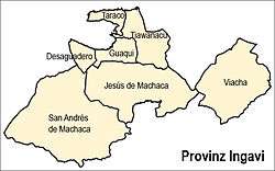 Location of the municipality within Ingavi province | |
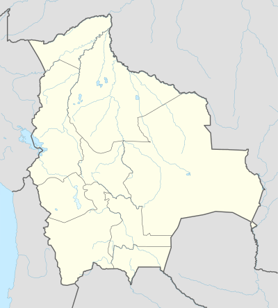 Taraco Municipality Location of the Taraco Municipality within Bolivia | |
| Coordinates: 16°27′0″S 68°50′0″W | |
| Country | |
| Department | La Paz Department |
| Province | Ingavi Province |
| Seat | Taraco |
| Government | |
| • Mayor | Idelfonso Choque Cortez (2008) |
| • President | Fidel Tapia Choquehuanca (2008) |
| Area | |
| • Total | 42 sq mi (108 km2) |
| Elevation | 12,800 ft (3,900 m) |
| Population (2001) | |
| • Total | 5,922 |
Division
The municipality is divided into the following cantons:[1]
- Santa Rosa de Taraco - 1,071 inhabitants (2001)
- Taraco - 4,851 inhabitants
The people
The people are predominantly indigenous citizens of Aymara descent.[2]
| Ethnic group | % |
|---|---|
| Quechua | 0.2 |
| Aymara | 96.4 |
| Guaraní, Chiquitos, Moxos | 0.0 |
| Not indigenous | 3.3 |
| Other indigenous groups | 0.1 |
Places of interest
Some of the tourist attractions of the municipalities are:[3]
- the archaeological sites on Taraco Peninsula:
- Chiripa and its museum
- Kala Uyuni, Pumani and Achacachi Coacollo in Coacollo
- Iwawi (Kolata Quenacache, Ojje Puku, Awichu and Chojna Qala) in Higuagui Grande
- Sikuya Island in Taraco Canton
- The church of Taraco dating from 1767
- Taraco museum in Taraco Canton
References
- National Institute of Statistics of Bolivia
- obd.descentralizacion.gov.bo/municipal/fichas/ (inactive)
- www.gobernacionlapaz.gob.bo Archived 2011-05-09 at the Wayback Machine Tourist guide by the government of the department
External links
This article is issued from Wikipedia. The text is licensed under Creative Commons - Attribution - Sharealike. Additional terms may apply for the media files.