Taplow
Taplow is a village and civil parish in the Unitary Authority of Buckinghamshire, England. It sits on the left bank of the River Thames, facing Maidenhead in the neighbouring county of Berkshire, with Cippenham and Burnham to the east. It is the south-westernmost settlement in Buckinghamshire.
| Taplow | |
|---|---|
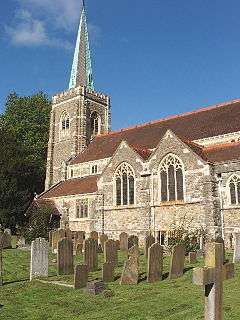 The mock-medieval parish church of St Nicholas, built in 1911. | |
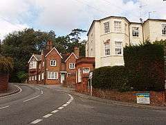 Berry Hill, part of the developed traditional core | |
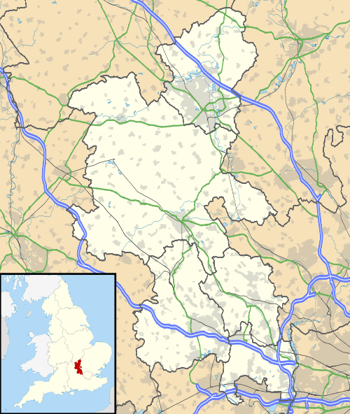 Taplow Location within Buckinghamshire | |
| Area | 11.22 km2 (4.33 sq mi) |
| Population | 1,669 (2011 census)[1] |
| • Density | 149/km2 (390/sq mi) |
| OS grid reference | SU9182 |
| Civil parish |
|
| Unitary authority | |
| Ceremonial county | |
| Region | |
| Country | England |
| Sovereign state | United Kingdom |
| Post town | MAIDENHEAD |
| Postcode district | SL6 |
| Dialling code | 01628 |
| Police | Thames Valley |
| Fire | Buckinghamshire |
| Ambulance | South Central |
| UK Parliament | |
The village features a Grade II listed mock-medieval church, the parish church of St Nicholas,[2] as well as a school of the same name. Taplow railway station, on the Great Western main line, serves the village, with services to London Paddington, Reading and Oxford.
There are two conservation areas in the parish, the Taplow Village Conservation Area[3] and the Taplow Riverside Conservation Area.[4]
Footpaths connect all parts of the parish to Maidenhead Bridge and to Burnham Beeches, a modest, hilly wood marking the start of the Chiltern Hills.
History
The village has a geological Site of Special Scientific Interest, South Lodge Pit, dating to the late Cretaceous.[5][6]
The village's name is Anglo-Saxon in origin, and means Tæppa's barrow; the Anglo-Saxon burial mound of Tæppa can still be visited, and important artefacts excavated there are now in the British Museum, notably a gold belt buckle. Taplow was recorded in the Domesday Book of 1086 as Thapeslau. Taplow Court nearby is also the site of an early Iron Age hill fort and was the site of the manor house.[7][8]
William Grenfell, 1st Baron Desborough lived at Taplow Court.[9] Neighbouring is Cliveden, former home and parkland of Nancy Astor in the parish. Both aspects of Cliveden are today open under the National Trust scheme though part of the main building is used as a hotel for visiting dignitaries to the UK.
In 1883 a number of important Anglo-Saxon royal grave goods were discovered, reflecting similar discoveries in Prittlewell, Broomfiled, and Sutton Hoo. Though the overall collection is less than that from the ship-burial in Mound 1 at Sutton Hoo, many individual objects are closely comparable and of similar quality.
The church of St Nicholas was built in 1911 but includes one of the earliest surviving brass memorials to a civilian in England, made in about 1350, which would place it during the Black Death.[2]
Demography
| Taplow compared | |||
|---|---|---|---|
| 2001 UK Census | Taplow ward | South Bucks borough | England |
| Population | 1,584 | 61,945 | 49,138,831 |
| Foreign born | 14.9% | 12.2% | 9.2% |
| White | 96.1% | 93.4% | 90.9% |
| Asian | 2.3% | 4.5% | 4.6% |
| Black | 0.0% | 0.4% | 2.3% |
| Christian | 73.4% | 75.6% | 71.7% |
| Muslim | 0.4% | 1.1% | 3.1% |
| Hindu | 0.8% | 1.2% | 1.16 |
| No religion | 17.1% | 12.5% | 14.6% |
| Unemployed | 1.3% | 1.9% | 3.3% |
| Retired | 12.7% | 14.8% | 13.5% |
At the 2011 UK census, the Taplow electoral ward had a population of 1,669. The ethnicity was 92.5% white, 1.0% mixed race, 5.0% Asian, 0.8% black and 0.7% other. The place of birth of residents was 85.1% United Kingdom, 1% Republic of Ireland, 4.6% other Western European countries, and 9.3% elsewhere. Religion was recorded as 64.1% Christian, 1.6% Buddhist, 0.5% Hindu, 1.6% Sikh, 0.3% Jewish, and 1.3% Muslim. 24.1% were recorded as having no religion, 0% had an alternative religion and 5.9% did not state their religion.[10]
The economic activity of residents aged 16–74 was 46.8% in full-time employment, 8.7% in part-time employment, 16.7% self-employed, 1.3% unemployed, 0.9% students with jobs, 2.5% students without jobs, 12.7% retired, 6.2% looking after home or family, 1.7% permanently sick or disabled and 2.7% economically inactive for other reasons. The industry of employment of residents was 12.3% retail, 11.8% manufacturing, 4.5% construction, 24.6% real estate, 7.8% health and social work, 5.7% education, 9.1% transport and communications, 2.7% public administration, 6.7% hotels and restaurants, 2.7% finance, 3% agriculture and 9.1% other. Compared with national figures, the ward had a relatively high proportion of workers in agriculture and real estate. According to Office for National Statistics estimates, during the period of April 2001 to March 2002 the average gross weekly income of households was £840, compared with an average of £660 in South East England. Of the ward's residents aged 16–74, 37.2% had a higher education qualification or the equivalent, compared with 19.9% nationwide.[11]
| Output area | Homes owned outright | Owned with a loan | Socially rented | Privately rented | Other | km² roads | km² water | km² domestic gardens | km² domestic buildings | km² non-domestic buildings | Usual residents | km² |
|---|---|---|---|---|---|---|---|---|---|---|---|---|
| Civil parish | 353 | 244 | 28 | 139 | 19 | 0.258 | 0.494 | 0.421 | 0.087 | 0.086 | 1669 | 11.22 |
Sports
The village's football club are Taplow United F.C. who play in the Hellenic Football League. The village cricket club is located on the Cliveden Road and the rugby union side, Phoenix RFC is located on Institute Road near the railway station.
Notable people
- Pascoe Grenfell - British businessman and politician
- Terry Wogan - Irish TV and radio presenter
- Dusty Springfield - British recording artist/producer
- Jessica Fox - British actress
References
- Key Statistics: Dwellings; Quick Statistics: Population Density; Physical Environment: Land Use Survey 2005
- Historic England. "Details from listed building database (1309135)". National Heritage List for England. Retrieved 25 January 2015.
- "Taplow Village Conservation Area" (PDF). South Bucks District Council. June 2008. Retrieved 4 November 2015.
- "Taplow Riverside Conservation Area" (PDF). South Bucks District Council. October 2007. Retrieved 4 November 2015.
- "South Lodge Pit citation" (PDF). Sites of Special Scientific Interest. Natural England. Retrieved 29 February 2016.
- "Map of South Lodge Pit". Sites of Special Scientific Interest. Natural England. Retrieved 29 February 2016.
- Bucks Archeological Service Historic Environment Resource Assessment
- Hart, Jonathan; Mc Sloy, E. R.; Mudd, Andrew (2011). "A Late Prehistoric Hilltop Settlement and Other Excavations Along the Taplow and Dorney Water Pipeline". Records of Buckinghamshire. Buckinghamshire Archeological Society. 51. Retrieved 8 August 2018.
- Christopher Winn, I Never Knew That About the River Thames (Random House, 2010) ISBN 0-09-193357-9 p.138
- UK Census (2011). "Local Area Report – Taplow 2011 Census Ward (1237322176)". Nomis. Office for National Statistics. Retrieved 18 February 2018.
- "Neighbourhood Statistics". Office for National Statistics. Retrieved 20 April 2008.
External links
| Wikimedia Commons has media related to Taplow. |
South Bucks District | ||
|---|---|---|
| ||
| Towns (component areas and hamlets) |  | |
| Other civil parishes (component villages and hamlets) |
| |
| Former districts and boroughs | ||
| Former constituencies | ||
| Authority control |
|
|---|