Takapuna
Takapuna is a central, coastal suburb of North Shore, Auckland, located in the northern North Island of New Zealand, at the beginning of a south-east-facing peninsula forming the northern side of the Waitematā Harbour. While very small in terms of population, it was the seat of the North Shore City Council before amalgamation into Auckland Council in 2010 and contains substantial shopping and entertainment areas, being considered the CBD of the North Shore.
Takapuna | |
|---|---|
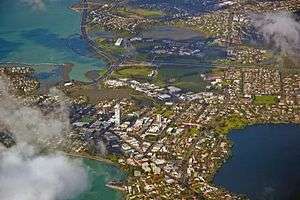 Looking west over Takapuna. | |
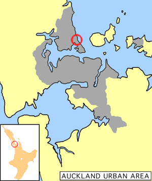 Location of Takapuna. | |
 Takapuna Location of Takapuna. | |
| Coordinates: 36.78919°S 174.77231°E | |
| Country | New Zealand |
| Local authority | Auckland Council |
| Population (2013) | |
| • Total | 3,144 |
| Postcode(s) | 0622 |
| Hospitals(s) | North Shore Hospital |
| Westlake | (Lake Pupuke) | Milford |
| Hillcrest |
|
(Hauraki Gulf) |
| Northcote | (Waitematā Harbour) | Hauraki, Belmont |
The population of the census area of "Takapuna Central" was 3,144 in the 2013 census, an increase of 330 from 2006.[1]
Geography

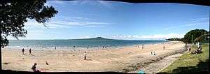

Takapuna is located on the isthmus of a peninsula which extends south into the northern waters of the Waitemata at the harbour's eastern end. As such, the suburb has a coastline on Shoal Bay, an arm of the Waitemata to the southwest, as well as having a coast on the Hauraki Gulf to the northeast. The northern end of the suburb is dominated by the large volcanic crater of Lake Pupuke. Some points in Takapuna are less than 500 metres from all three of these bodies of water. The Hauraki coastline includes a kilometre long crescent shaped beach (Takapuna Beach) which is a popular recreation area.
To the southeast of Takapuna lies the six-kilometre-long peninsula which contains the suburbs of Belmont and Devonport. To the west lie the suburbs of Hillcrest and Northcote. The suburb of Milford lies to the north, on the far shore of Lake Pupuke.
History
The Māori place name Takapuna originally referred to a freshwater spring that flowed from the base of North Head into a swamp behind Cheltenham Beach.[2] In 1841 the wife of Eruera Maihi Patuone sold 9500 acres of Auckland's North Shore to the Crown.[3] Referred to as Takapuna Parish, the North Shore was surveyed and subdivided in 1844.[4] In 1851 Governor Grey gifted back to Patuone 110 acres between the inlet beside Barry's Point Road and Takapuna Beach to use until his death (1872). This area included a Māori settlement known as Waiwharariki, on the small Shoal Bay headland now crossed by Esmonde Road.[5]
The earliest subdivisions of farmland for suburban development were the "Hurstmere" estate in 1886[6] and the "Pupuke" Estate in 1889. The Takapuna and Milford Beach areas, as well as the land surrounding Lake Pupuke soon became popular spots for wealthy businessmen building summer homes to entertain in a rural surrounding, and eventually, many moved here permanently, commuting to work in Auckland via ferry.[7]
A local history archive is maintained by the New Zealand Collection of Takapuna Public Library. It includes an index of the local newspapers, archives, photographs, oral histories, and historical material relating to Takapuna.[8]
Local government
Takapuna had a local government like other suburbs in Auckland at that time. The local government was called Takapuna Borough Council, which started in 1913 and merged into Takapuna City Council in 1961. Then it merged into North Shore City Council in 1989, eventually amalgamating into Auckland Council in November 2010.
Mayors during Takapuna Borough Council
- 1913–1914 Ewen William Alison
- 1914–1921 William Blomfield
- 1921–1924 Arthur Mason Gould
- 1924–1925 James William Hayden
- 1925–1927 John D. M. Morrison
- 1927–1931 Julius Warwick W. Williamson
- 1931–1950 John Guiniven
- 1950–1956 Douglas Raymond Sheath
- 1956–1961 William Holmes Henderson
Mayors during Takapuna City Council
- 1961–1965 William Holmes Henderson
- 1965–1986 Arthur Frederick Thomas
- 1986–1989 Winifred "Wyn" Norien Hoadley
Today
The Takapuna Beach area is a nightlife hub and boutique shopping centre of the North Shore, having many bars, restaurants, cafes and shops.
The Block NZ's first season took place in Takapuna.[9]
Shania Twain's 2003 music video for When You Kiss Me was also shot in Takapuna.
As a recognised area by council for future intensification, the beachfront will become the backyard for the estimated 15,000 residents and 15,000 employees who will inhabit Takapuna by 2040.
The area has potential in its central business area and wider precincts to further develop into the southern hub of the North Shore.[10]
Sport
Takapuna is home to Takapuna AFC who compete in the Lotto Sport Italia NRFL Division 1A.
Onewa domain was the former home ground of North Harbour, but the team has since moved to QBE Stadium.
Since 1974 Takapuna Rugby Football Club club has been located at Onewa Domain , even though it is in the suburb of Northcote . Prior to that Takapuna RFC were located at Taharoto Park which is located on Taharoto Rd , Takapuna
Education
Rosmini College is a boys' secondary (years 7-13) school with a roll of 1,086.[11] St Joseph's School is a coeducational contributing primary (years 1-6) school with a roll of 400.[12] They are state integrated Catholic schools located adjacent to each other. Rosmini College was founded in 1962,[13] and St Joseph's in 1894.[14]
Takapuna Normal Intermediate is a coeducational intermediate (years 7-8) school with a roll of 604.[15] It was established in 1970.[16] Takapuna School is a coeducational contributing primary (years 1-6) school with a roll of 472.[17] It celebrated its 125th jubilee in 2004.[18] All these schools have a high decile rating (respectively of 9, and 8).
Takapuna Grammar School is in Belmont, to the southeast of Takapuna. It is the main public secondary school in the area (years 9-15) with a 2018 roll of 1678. Its funding decile is 10. [19]
Notable residents
- Lorde - singer-songwriter
- Winston Reid - West Ham United footballer
- Pamela Stephenson - TV personality,Psychologist, Comedian
References
- "2013 Census QuickStats about a place: Takapuna Central". Retrieved 27 May 2018.
- "New home in an old haven" (PDF). Museumsotearoa.org.nz. Retrieved 8 August 2016.
- "Patuone, Eruera Maihi – Biography – Te Ara: The Encyclopedia of New Zealand". Teara.govt.nz. Retrieved 8 August 2016.
- "Inmagic DB/Text WebPublisher PRO: 1 records". Manukau.infospecs.co.nz. Retrieved 8 August 2016.
- "Archived copy" (PDF). Archived from the original (PDF) on 2 July 2015. Retrieved 2015-02-26.CS1 maint: archived copy as title (link)
- Anderson, Louise (January 2002). "Takapuna - Milford Walk" (PDF). North Shore: North Shore City. p. 6. Retrieved 14 April 2012.
- "Archived copy" (PDF). Archived from the original (PDF) on 28 September 2007. Retrieved 2007-06-03.CS1 maint: archived copy as title (link)
- "Archived copy". Archived from the original on 29 August 2006. Retrieved 2006-08-24.CS1 maint: archived copy as title (link)
- Hallahan, Marnie (31 May 2012). "Bargains on The Block". Stuff.co.nz. Retrieved 6 August 2016 – via Stuff.co.nz.
- "Takapuna Beach Business Association". Takapunabeach.co.nz. Retrieved 6 August 2016.
- Education Counts: Rosmini College Retrieved 09 August 2019.
- Education Counts: St Joseph's School Retrieved 9 Aug 2019.
- "International Students". Rosmini College. Archived from the original on 14 October 2008. Retrieved 21 February 2009.
- "About Us". St Joseph's School. Archived from the original on 9 November 2007. Retrieved 21 February 2009.
- Education Counts: Takapuna Normal Intermediate Retrieved 9 Aug 2019
- "Case study of ARB use at Takapuna Normal Intermediate School". Arb.nzcer.org.nz. Archived from the original on 20 November 2008. Retrieved 2009-02-21.
- Education Counts: Takapuna School Retrieved 27 May 2018
- "Takapuna Primary School 125th Jubilee". Education Gazette New Zealand. 83 (18). 4 October 2004.
- "Takapuna Grammar School - Student Population". Retrieved 9 August 2019.
External links
| Wikimedia Commons has media related to Takapuna. |
| Wikivoyage has a travel guide for Takapuna. |
- Takapuna Beach (website of the local business association)
- Photographs of Takapuna held in Auckland Libraries' heritage collections.