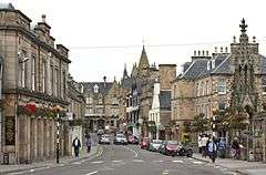
Tain
Tain (Gaelic: Baile Dhubhthaich) is a royal burgh and parish in the County of Ross, in the Highlands of Scotland.
Tain
| |
|---|---|
 | |
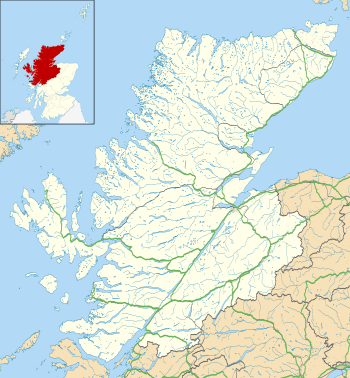 Tain Location within the Highland council area | |
| Area | 2.12 km2 (0.82 sq mi) |
| Population | 3,590 [1] |
| • Density | 1,693/km2 (4,380/sq mi) |
| OS grid reference | NH779821 |
| • Edinburgh | 133 mi (214 km) |
| • London | 463 mi (745 km) |
| Council area | |
| Lieutenancy area | |
| Country | Scotland |
| Sovereign state | United Kingdom |
| Post town | TAIN |
| Postcode district | IV19 |
| Dialling code | 01862 |
| Police | Scotland |
| Fire | Scottish |
| Ambulance | Scottish |
| UK Parliament | |
| Scottish Parliament | |
Etymology
The name derives from the nearby River Tain, the name of which comes from an Indo-European root meaning 'flow'.[2] The Gaelic name, Baile Dubhthaich, means 'Duthac's town', after a local saint also known as Duthus.[3]
Facilities
Tain railway station is on the Far North Line. The station is unmanned; in its heyday it had 30 staff. The station was opened by the Highland Railway on 1 January 1864. From 1 January 1923, the station was owned by the London Midland and Scottish Railway. Then in 1948 the British railways were nationalised as British Railways. When the railways were privatised, the station became part of ScotRail.
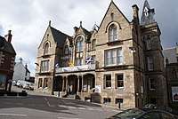
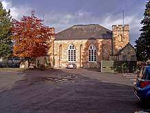
Notable buildings in the town include Tain Tolbooth and St Duthus Collegiate Church. The town also has a local history museum, Tain Through Time, and the Glenmorangie distillery.
Tain has two primary schools; Craighill (274 pupils as of April 2011) and Knockbreck (just under 120 pupils as of April 2011). There is also a secondary school, Tain Royal Academy, with 590 pupils as of January 2017.
History
Tain was granted its first royal charter in 1066, making it Scotland's oldest royal burgh,[4] commemorated in 1966 with the opening of the Rose Garden by Queen Elizabeth, the Queen Mother. The 1066 charter, granted by King Malcolm III, confirmed Tain as a sanctuary, where people could claim the protection of the church, and an immunity, in which resident merchants and traders were exempt from certain taxes. These led to the development of the town.
Little is known of earlier history although the town owed much of its importance to Duthac. He was an early Christian figure, perhaps 8th or 9th century, whose shrine had become so important by 1066 that it resulted in the royal charter. The ruined chapel near the mouth of the river was said to have been built on the site of his birth. Duthac became an official saint in 1419 and by the late Middle Ages his shrine was an important places of pilgrimage in Scotland. King James IV came at least once a year throughout his reign to achieve both spiritual and political aims.
A leading landowning family of the area, the Clan Munro, provided political and religious figures to the town, including the dissenter Rev John Munro of Tain (died ca. 1630).
The early Duthac Chapel was the centre of a sanctuary. Fugitives were by tradition given sanctuary in several square miles marked by boundary stones. During the First War of Scottish Independence, Robert the Bruce sent his wife and daughter to the sanctuary for safety. The sanctuary was violated and they were captured by forces loyal to William II, Earl of Ross who handed them over to Edward I of England[5] The women were taken to England and kept prisoner for several years.
RAF Tain
With conflict looming in the 1930s, an aerodrome large enough for bombers was built next to the town on low alluvial land known as the Fendom bordering the Dornoch Firth. It was home to British, Czech (311 Sqn) and Polish airmen during the Second World War. It was abandoned as a flying location after the war and converted to a bombing range for the Fleet Air Arm of the Royal Navy. When British naval aviation moved from large fleet aircraft carriers, the role was taken over by the RAF. In 1939 RAF Station Lossiemouth opened and was used until 1946 when the airfield was transferred to the Admiralty and becoming Royal Naval Air Station (RNAS) Lossiemouth then returning to the RAF in 1972 as a RAF airfield and the Tain range reverted to the RAF. Large parts of the original aerodrome were returned to civilian use after the Second World War and some are still accessible.[6]
Sport & recreation
Tain Golf Club offers a Championship length links golf course. Overlooking the Dornoch Firth, the course was first designed by Old Tom Morris in 1890.[7]
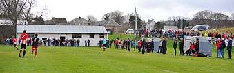
Tain is represented in the Scottish Football Association affiliated North Caledonian Football League by senior football club St Duthus Football Club during the regular football season. Tain is also represented by recreational football club Tain Thistle Football Club in the Ross-shire Welfare League during the summer. Home matches are played at the Links Playing Fields.
Sport facilities are available at the Tain Royal Academy Community Complex. These facilities include an indoor 20-metre swimming pool, fitness suite, indoor hall, gymnasium and an outdoor all weather surface for field activities.
Other sports clubs in Tain include St Duthus Bowling Club, Tain Tennis Club, Tain Rifle & Pistol Club, The Scottish Kempo Academy and Nicholson Kempo Jujitsu.
Local geographical and visitor features
The Gizzen Briggs are sandbars at the entrance to the Dornoch Firth, and with the right wind, they can be heard at low tide. The so-called "million dollar view" to the north-west of Tain, accessible via the A836 westward towards Bonar Bridge and then the B9176 Struie Road, gives a panoramic view of Dornoch Firth and Sutherland.
Five important castles are in the vicinity - Carbisdale Castle, built for the Dowager Duchess of Sutherland and now a youth hostel; Skibo Castle, once home of the industrialist Andrew Carnegie and now a hotel; Dunrobin Castle, ancestral seat of the Duke of Sutherland (castle and gardens open to the public); Balnagown Castle, ancestral seat of the Clan Ross, restored and owned by Mohammed Al Fayed; and Ballone Castle, restored by the owners of a local crafts business.
Glenmorangie distillery and visitor centre is located just off the A9 on the outskirts of Tain.
Highland Fine Cheeses, run by Ruaridh Stone (the brother of Liberal Democrat MP Jamie Stone), have a factory at Blarliath Farm, Tain.
Tain has a library, community centre, two four-star hotels, several cafes, takeaway restaurants and a town hall.
Just outside Hill of Fearn near Tain lies the site of the medieval Fearn Abbey; the parish church of the same name dates from 1772.
Parliamentary burgh
Tain was a parliamentary burgh, combined with Dingwall, Dornoch, Kirkwall and Wick in the Northern Burghs constituency of the House of Commons of the Parliament of Great Britain from 1708 to 1801 and of the Parliament of the United Kingdom from 1801 to 1918. Cromarty was added to the list in 1832.
The constituency was a district of burghs known also as Tain Burghs until 1832, and then as Wick Burghs. It was represented by one Member of Parliament. In 1918 the constituency was abolished, and Tain was merged into Ross and Cromarty.
Notable people
- Saint Duthac (1000–1065), 11th century saint
- Sir John Fraser (1885–1947), surgeon
- George MacKenzie FRSE (1886–1957), president of the Institute of Banking 1941-5[8]
- John Ross (1726–1800)
- Rev John Munro of Tain, 17th-century religious dissenter, was a minister here.
- Peter Fraser (1884–1950), 24th prime minister of New Zealand, was born in Hill of Fearn a village nearby Tain.
- Professor Thomas Summers West CBE,FRS, (1927–2010), an internationally acclaimed analytical chemist, went to school at Tain Royal Academy.[9]
- Rev David Robertson (1962–) the former Free Church of Scotland moderator and Christian commentator, grew up in Portmahomack.
- Elizabeth Ness MacBean Ross (1878–1915), physician who was raised here and attended Tain Royal Academy.
- Very Rev Walter Ross Taylor (1805–1896), served as Moderator of the General Assembly to the Free Church of Scotland in 1884.
- Scott Johnston (1996-) Scottish actor and kitchen porter grew up in nearby Portmahomack
Climate
Tain has an oceanic climate (Köppen: Cfb) with cool to mild temperatures year round.
| Climate data for Tain Range (4 m or 13 ft asl, averages 1981–2010) | |||||||||||||
|---|---|---|---|---|---|---|---|---|---|---|---|---|---|
| Month | Jan | Feb | Mar | Apr | May | Jun | Jul | Aug | Sep | Oct | Nov | Dec | Year |
| Average high °C (°F) | 6.4 (43.5) |
7.0 (44.6) |
9.1 (48.4) |
11.3 (52.3) |
13.8 (56.8) |
16.3 (61.3) |
18.4 (65.1) |
18.1 (64.6) |
16.0 (60.8) |
12.5 (54.5) |
9.0 (48.2) |
6.4 (43.5) |
12.1 (53.8) |
| Average low °C (°F) | 0.4 (32.7) |
0.3 (32.5) |
1.8 (35.2) |
3.3 (37.9) |
5.4 (41.7) |
8.4 (47.1) |
10.5 (50.9) |
10.2 (50.4) |
8.0 (46.4) |
5.2 (41.4) |
2.5 (36.5) |
0.0 (32.0) |
4.7 (40.5) |
| Average rainfall mm (inches) | 59.5 (2.34) |
45.9 (1.81) |
51.9 (2.04) |
40.7 (1.60) |
48.7 (1.92) |
51.7 (2.04) |
54.2 (2.13) |
56.9 (2.24) |
53.7 (2.11) |
71.4 (2.81) |
59.4 (2.34) |
52.5 (2.07) |
646.4 (25.45) |
| Average rainy days (≥ 1 mm) | 13.0 | 11.0 | 12.9 | 9.5 | 11.1 | 10.8 | 10.9 | 11.3 | 10.3 | 14.3 | 12.3 | 13.6 | 140.8 |
| Mean monthly sunshine hours | 40 | 70 | 102 | 138 | 184 | 152 | 143 | 133 | 112 | 83 | 49 | 31 | 1,237 |
| Source 1: Met Office[10] | |||||||||||||
| Source 2: Scottish Places[11] | |||||||||||||
References
- "Tain (Highland, Scotland, United Kingdom) - Population Statistics, Charts, Map, Location, Weather and Web Information". www.citypopulation.de. Retrieved 26 March 2019.
- Taylor, Iain. Place-names of Scotland. Edinburgh: Birlinn Ltd. p. 149. ISBN 978-1-78027-005-0.
- Iain Mac an Tailleir. "Placenames" (PDF). Pàrlamaid na h-Alba. Archived from the original (PDF) on 29 May 2008. Retrieved 23 July 2007.
- "Tain Community Website - History & Heritage". www.tain.org.uk. Retrieved 8 June 2016.
- Robert Bruce and the Community of the Realm of Scotland, by G.W.S. Barrow, published Edinburgh, 1965
- War Detectives. "Royal Air Force Tain". Retrieved 1 April 2008.
- "Home Page". Tain Golf Club. Retrieved 11 Apr 2011.
- Biographical Index of Former Fellows of the Royal Society of Edinburgh 1783 – 2002 (PDF). The Royal Society of Edinburgh. July 2006. ISBN 0 902 198 84 X.
- "Obituary, Thomas Summers West" (PDF). Royal Society of Edinburgh. Retrieved 20 June 2012.
- "Tain Range (Highland) UK climate averages". Met Office. Archived from the original on 21 March 2020. Retrieved 11 September 2019.
- "Climate information for Tain". Scottish Places. Archived from the original on 21 March 2020. Retrieved 17 October 2015.
External links
| Wikimedia Commons has media related to Tain. |
- Tain community website
- Tain Through Time
- Tain & District Field Club
- Tain Golf Club
- St Duthus Football Club
- Tain Thistle Football Club
| Authority control |
|
|---|