Dingwall
Dingwall (Scots: Dingwal,[1] Scottish Gaelic: Inbhir Pheofharain[2] [ˈiɲɪɾʲ ˈfjɔhəɾan]) is a town and a royal burgh in the Highland council area of Scotland. It has a population of 5,491. It was an east-coast harbour that now lies inland. Dingwall Castle was once the biggest castle north of Stirling. On the town's present-day outskirts lies Tulloch Castle, parts of which may date back to the 12th-century building. In 1411 the Battle of Dingwall is said to have taken place between the Clan Mackay and the Clan Donald.
Dingwall
| |
|---|---|
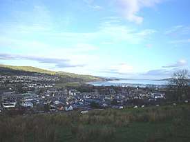 Looking across Dingwall to the Cromarty Firth | |
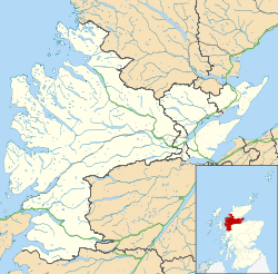 Dingwall Location within the Ross and Cromarty area | |
| Population | 6,545 (2011 census) |
| OS grid reference | NH550587 |
| • Edinburgh | 123 mi (198 km) |
| • London | 454 mi (731 km) |
| Council area | |
| Lieutenancy area | |
| Country | Scotland |
| Sovereign state | United Kingdom |
| Post town | DINGWALL |
| Postcode district | IV7, IV15, IV16 |
| Dialling code | 01349 |
| Police | Scotland |
| Fire | Scottish |
| Ambulance | Scottish |
| UK Parliament | |
| Scottish Parliament | |
| Website | http://www.dingwallcc.com |
History
Its name, derived from the Scandinavian Þingvöllr (field or meeting-place of the thing, or local assembly; compare Tynwald, Tingwall, Thingwall in the British Isles alone,[3] plus many others across northern Europe), preserves the Viking connections of the town; Gaels call it Inbhir Pheofharain (pronounced [iɲiɾʲˈfjɔhəɾaiɲ]), meaning "the mouth of the Peffery" or Baile Chàil meaning "cabbage town".[4][5]
The site of the Þingvöllr, and of the medieval Moothill, lies beneath the Cromartie memorial.
Dingwall formerly served as the county town of the county of Ross and Cromarty. It lies near the head of the Cromarty Firth where the valley of the Peffery unites with the alluvial lands at the mouth of the Conon, 14 miles (23 km) northwest of Inverness.

In the early Middle Ages Dingwall was reputed to have the largest castle north of Stirling.[6]
King Alexander II created Dingwall a royal burgh in 1226, and James IV renewed its charter. On the top of Knockfarrel (Scottish Gaelic: Cnoc Fhearghalaigh), a hill about three miles (5 km) to the west, stands a large and very complete vitrified fort with ramparts.
The 18th-century town house, and some remains of the ancient mansion of the once powerful earls of Ross, still exist. An obelisk, 51 feet (16 m) high, was erected over the grave of Sir George Mackenzie, 1st Earl of Cromartie, near the parish church of St Clement. It was affected by subsidence, becoming known as the "Leaning Tower", and was replaced by a much smaller replica in the early years of the 20th century. However even this is now marked by signs saying "Keep Out" on the grounds that it is a dangerous structure.
The Ferry Road drill hall was completed in 1910.[7]
Dingwall suffered widespread flooding during storms in late October 2006, during which the weather cut off much of the Highlands north of Inverness, including the A9 and Far North Line for a significant period of time.[8] Dingwall suffered another bout of flooding in August 2019. [9]
The town contains the shortest and most northerly canal in the UK, the Dingwall Canal, also known locally as the River Peffry.
Sports
Dingwall is the home of football team Ross County, who won promotion to the Scottish Premier League in 2012 and finished the 2012/13 season in fifth place. Despite the town's small population, Ross County attract sizeable crowds to Victoria Park thereby maintaining the most northerly full-time squad in the British Isles. The team reached the 2010 Scottish Cup Final, having knocked out Celtic in the previous round. Over 17,000 Staggies fans travelled to the match.
Ross County won their first piece of major silverware in 2016 by winning the Scottish League Cup beating Hibernian 2–1 in the final with the winning goal by Alex Schalk.[10]
Transport
Dingwall railway station has lain on what is now called the Far North Line since circa 1865. It also serves the Kyle of Lochalsh Line, with the junction between the two lines being located within the town. The station is served with around 26 trains a day, 14 of which go to Inverness.
Dingwall is on the former line of the main road route to the north Highlands. After the completion of the Cromarty Bridge in 1979, this was designated the A9 road, thus bypassing Dingwall. Heading west, the A834 joins the A835 road which is the main route to the north west Highlands, including Ullapool.
Education
Dingwall Academy is the Secondary School that covers the town, as well as the wider area. Its catchment area includes 9 primary schools, bringing in pupils from Dingwall as well as Conon Bridge, Garve, Maryburgh, Marybank, Muir of Ord, Strathpeffer, and the surrounding area. Within the town there is Dingwall Primary School.
The town also has St Clement's School which is for pupils with additional support needs, and caters for both primary and secondary aged children.
The Highland Theological College is located within the town, housed in a former Hydro Electric office. It is one of 13 campuses of the University of the Highlands and Islands and has been approved by the Church of Scotland, the United Free Church and other denominations as a training provider for those entering ministry.
Parliamentary Burgh
Dingwall was a parliamentary burgh, combined with Dornoch, Kirkwall, Tain and Wick in the Northern Burghs constituency of the House of Commons of the Parliament of Great Britain from 1708 to 1801 and of the Parliament of the United Kingdom from 1801 to 1918. Cromarty was added to the list in 1832.
The constituency was a district of burghs known also as Tain Burghs until 1832, and then as Wick Burghs. It was represented by one Member of Parliament. In 1918 the constituency was abolished and the Dingwall component was merged into the county constituency of Ross and Cromarty.
Notable Locals
- James Fraser of Brea theologian and prisoner on the Bass Rock
- Prof James Alexander MacDonald FRSE FIB (1908-1997) botanist, born and raised in Dingwall.[11]
- Major General Sir Hector Archibald MacDonald, KCB, DSO Son of a local Crofter at Rootfield, Dingwall.
- John M'Gilligen of Fodderty who held conventicles in houses throughout the county
- Rev Duncan Leitch, Moderator of the General Assembly of the Free Church of Scotland in 1952
References
- "Scots Language Centre: Scottish Place Names in Scots". Scotslanguage.com. Retrieved 10 October 2012.
- "Ainmean-Àite na h-Alba ~ Gaelic Place-Names of Scotland". Gaelicplacenames.org. Retrieved 10 October 2012.
- Fellows Jensen, Gillian (1993). "'Tingwall, Dingwall and Thingwall'. North-Western European Language Evolution, 21:22". Odense University Press. p. 53–67.
- "Dingwall". Gaelic Place names of Scotland. Retrieved 24 June 2017.
- "The illustrated Gaelic dictionary". Archive.org. Retrieved 10 October 2012.
- Norman Macrae, Romance of a Royal Burgh: Dingwall's Story of a Thousand Years Publisher: EP Publishing Ltd. ISBN 0715810715
- "Dingwall, Ferry Road, Drill Hall, War Memorial". Canmore. Retrieved 24 June 2017. (The 1:2500, 2nd edition, Ordnance Survey Plan no. 88.03 (Ross and Cromarty), published in 1906, does not show the drill hall)
- "Rain turns north into water world", BBC News.
- Aiken, Gregor. "Dingwall hit with floods". Press and Journal. Retrieved 23 November 2019.
- Information from BBC by Richard Wilson
- Biographical Index of Former Fellows of the Royal Society of Edinburgh 1783–2002 (PDF). The Royal Society of Edinburgh. July 2006. ISBN 0 902 198 84 X.
External links
| Wikimedia Commons has media related to Dingwall, Highland. |
| Authority control |
|
|---|