Tagana-an
Tagana-an, officially the Municipality of Tagana-an, is a 5th class municipality in the province of Surigao del Norte, Philippines. According to the 2015 census, it has a population of 16,428 people.[3]
Tagana-an | |
|---|---|
| Municipality of Tagana-an | |
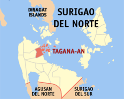 Map of Surigao del Norte with Tagana-an highlighted | |
| |
.svg.png) Tagana-an Location within the Philippines | |
| Coordinates: 9°42′N 125°35′E | |
| Country | |
| Region | Caraga (Region XIII) |
| Province | Surigao del Norte |
| District | 2nd District |
| Founded | June 22, 1947 |
| Barangays | 14 (see Barangays) |
| Government | |
| • Type | Sangguniang Bayan |
| • Mayor | Cesar B. Diaz Jr. |
| • Vice Mayor | Cesar A. Diaz |
| • Congressman | Robert Ace S. Barbers |
| • Electorate | 13,050 voters (2019) |
| Area | |
| • Total | 77.29 km2 (29.84 sq mi) |
| Elevation | 10.9 m (35.8 ft) |
| Population (2015 census)[3] | |
| • Total | 16,428 |
| • Density | 210/km2 (550/sq mi) |
| • Households | 3,733 |
| Economy | |
| • Income class | 5th municipal income class |
| • Poverty incidence | 45.3% (2015)[4] |
| • Revenue (₱) | 139,351,817.47 (2016) |
| Time zone | UTC+8 (PST) |
| ZIP code | 8403 |
| PSGC | |
| IDD : area code | +63 (0)86 |
| Climate type | tropical rainforest climate |
| Native languages | Surigaonon Agusan language Cebuano Tagalog |
| Website | www |
It was created by virtue of Republic Act No. 194 on June 22, 1947.[5]
Barangays
Tagana-an is politically subdivided into 14 barangays.
- Aurora (Poblacion)
- Azucena (Poblacion)
- Banban
- Cawilan
- Fabio
- Himamaug
- Laurel
- Lower Libas
- Opong
- Patino
- Sampaguita (Poblacion)
- Talavera
- Union
- Upper Libas
Sitio Dijo (under barangay Banban)
Demographics
| Population census of Tagana-an | ||
|---|---|---|
| Year | Pop. | ±% p.a. |
| 1903 | 1,656 | — |
| 1948 | 6,116 | +2.95% |
| 1960 | 7,460 | +1.67% |
| 1970 | 8,063 | +0.78% |
| 1975 | 9,285 | +2.87% |
| 1980 | 10,290 | +2.08% |
| 1990 | 11,585 | +1.19% |
| 1995 | 12,159 | +0.91% |
| 2000 | 12,844 | +1.18% |
| 2007 | 14,199 | +1.39% |
| 2010 | 15,366 | +2.92% |
| 2015 | 16,428 | +1.28% |
| Source: Philippine Statistics Authority[3][6][7][8] | ||
Climate
| Climate data for Tagana-an, Surigao del Norte | |||||||||||||
|---|---|---|---|---|---|---|---|---|---|---|---|---|---|
| Month | Jan | Feb | Mar | Apr | May | Jun | Jul | Aug | Sep | Oct | Nov | Dec | Year |
| Average high °C (°F) | 27 (81) |
28 (82) |
28 (82) |
30 (86) |
30 (86) |
30 (86) |
29 (84) |
30 (86) |
30 (86) |
29 (84) |
29 (84) |
28 (82) |
29 (84) |
| Average low °C (°F) | 23 (73) |
23 (73) |
23 (73) |
23 (73) |
25 (77) |
25 (77) |
25 (77) |
25 (77) |
25 (77) |
25 (77) |
24 (75) |
24 (75) |
24 (75) |
| Average precipitation mm (inches) | 210 (8.3) |
161 (6.3) |
123 (4.8) |
85 (3.3) |
148 (5.8) |
186 (7.3) |
164 (6.5) |
157 (6.2) |
141 (5.6) |
190 (7.5) |
223 (8.8) |
200 (7.9) |
1,988 (78.3) |
| Average rainy days | 21.0 | 16.8 | 18.5 | 18.2 | 24.9 | 27.7 | 28.4 | 27.0 | 26.1 | 27.6 | 24.6 | 22.0 | 282.8 |
| Source: Meteoblue [9] | |||||||||||||
References
- "Municipality". Quezon City, Philippines: Department of the Interior and Local Government. Retrieved 31 May 2013.
- "Province: Surigao del Norte". PSGC Interactive. Quezon City, Philippines: Philippine Statistics Authority. Retrieved 12 November 2016.
- Census of Population (2015). "Caraga". Total Population by Province, City, Municipality and Barangay. PSA. Retrieved 20 June 2016.
- "PSA releases the 2015 Municipal and City Level Poverty Estimates". Quezon City, Philippines. Retrieved 12 October 2019.
- "An act creating the municipality of Tagana-an, province of Surigao". LawPH.com. n.d. Retrieved 2011-04-08.
- Census of Population and Housing (2010). "Caraga". Total Population by Province, City, Municipality and Barangay. NSO. Retrieved 29 June 2016.
- Censuses of Population (1903–2007). "Caraga". Table 1. Population Enumerated in Various Censuses by Province/Highly Urbanized City: 1903 to 2007. NSO.
- "Province of Surigao del Norte". Municipality Population Data. Local Water Utilities Administration Research Division. Retrieved 17 December 2016.
- "Tagana-an: Average Temperatures and Rainfall". Meteoblue. Retrieved 20 November 2019.
External links
- Tagana-an Profile at PhilAtlas.com
- Philippine Standard Geographic Code
- Philippine Census Information
- Local Governance Performance Management System
- Official Website of Tagana-an Industrial Park
Places adjacent to Tagana-an | ||||||||||
|---|---|---|---|---|---|---|---|---|---|---|
| ||||||||||
Surigao City (capital) | |
| Municipalities | |
| Component city | |
This article is issued from Wikipedia. The text is licensed under Creative Commons - Attribution - Sharealike. Additional terms may apply for the media files.