Tabor, Iowa
Tabor is a city in Fremont County and extends northward into Mills County[4] in the U.S. state of Iowa. The population was 1,040 at the 2010 census.
Tabor, Iowa | |
|---|---|
 | |
 Location of Tabor, Iowa | |
| Coordinates: 40°53′48″N 95°40′21″W | |
| Country | |
| State | |
| Counties | Fremont, Mills |
| Area | |
| • Total | 1.29 sq mi (3.34 km2) |
| • Land | 1.29 sq mi (3.34 km2) |
| • Water | 0 sq mi (0 km2) |
| Elevation | 1,253 ft (382 m) |
| Population | |
| • Total | 1,040 |
| • Estimate (2018)[3] | 990 |
| • Density | 806/sq mi (311.3/km2) |
| Time zone | UTC-6 (Central (CST)) |
| • Summer (DST) | UTC-5 (CDT) |
| ZIP code | 51653 |
| Area code(s) | 712 |
| FIPS code | 19-76935 |
| GNIS feature ID | 0462169 |
| Website | www.taboriowa.us |
Geography
Tabor is located at 40°53′48″N 95°40′21″W (40.896605, -95.672368).[5]
According to the United States Census Bureau, the city has a total area of 1.29 square miles (3.34 km2), all land.[1]
History
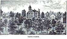
In 1852 the city of Tabor was founded by several Christian clergymen, who were also active abolitionists, (George Gaston, Samuel A. Adams, and Rev. John Todd) and their families. They chose to settle in what is now Tabor in order to found a Christian college, which eventually became Tabor College. The founders "were impressed with this high location and mutually selected the name "Tabor" after the Biblical name of Mount Tabor, a mountain near Nazareth, the town of Jesus' childhood""[6] In the 1850s the abolitionist John Brown kept a store of weapons in Tabor, and met here with other supporters to plan his raids in Kansas and Virginia, including the Raid on Harpers Ferry. The town was the home of many abolitionists, including John Tod, a "conductor" on the Underground Railroad and co-founder of Tabor College. Tabor College was located in the city from 1853 to 1927 before it closed for financial reasons. The college's buildings housed German Prisoners of War during World War II.
Demographics
| Historical populations | ||
|---|---|---|
| Year | Pop. | ±% |
| 1870 | 310 | — |
| 1880 | 320 | +3.2% |
| 1890 | 503 | +57.2% |
| 1900 | 934 | +85.7% |
| 1910 | 909 | −2.7% |
| 1920 | 1,186 | +30.5% |
| 1930 | 1,017 | −14.2% |
| 1940 | 976 | −4.0% |
| 1950 | 869 | −11.0% |
| 1960 | 909 | +4.6% |
| 1970 | 957 | +5.3% |
| 1980 | 1,088 | +13.7% |
| 1990 | 994 | −8.6% |
| 2000 | 993 | −0.1% |
| 2010 | 1,040 | +4.7% |
| 2018 | 990 | −4.8% |
| Source:"U.S. Census website". United States Census Bureau. Retrieved 2020-03-29. and Iowa Data Center Source: | ||
2010 census
At the 2010 census,[2] there were 1,040 people, 418 households and 272 families living in the city. The population density was 806.2 per square mile (311.3/km2). There were 451 housing units at an average density of 349.6 per square mile (135.0/km2). The racial makeup was 98.5% White, 0.7% African American, 0.3% Asian, 0.1% from other races, and 0.5% from two or more races. Hispanic or Latino of any race were 2.0% of the population.
There were 418 households of which 29.9% had children under the age of 18 living with them, 50.2% were married couples living together, 10.0% had a female householder with no husband present, 4.8% had a male householder with no wife present, and 34.9% were non-families. 31.6% of all households were made up of individuals and 15% had someone living alone who was 65 years of age or older. The average household size was 2.34 and the average family size was 2.95.
The median age was 44.3 years. 23.2% of residents were under the age of 18; 6.2% were between the ages of 18 and 24; 21.3% were from 25 to 44; 27.1% were from 45 to 64; and 22.2% were 65 years of age or older. The gender makeup of the city was 48.3% male and 51.7% female.
2000 census
At the 2000 census,[8] there were 993 people, 387 households and 267 families living in the city. The population density was 777.4 per square mile (299.5/km²). There were 416 housing units at an average density of 325.7 per square mile (125.5/km²). The racial makeup was 99.60% White, 0.10% Asian, and 0.30% from two or more races. 0.81% of the population was Hispanic or Latino of any race.
There were 387 households of which 30.5% had children under the age of 18 living with them, 55.6% were married couples living together, 11.6% had a female householder with no husband present, and 31.0% were non-families. 28.7% of all households were made up of individuals and 20.2% had someone living alone who was 65 or older. The average household size was 2.38 and the average family size was 2.91.
24.1% of the population were under the age of 18, 5.2% from 18 to 24, 22.6% from 25 to 44, 23.0% from 45 to 64, and 25.2% who were 65 years of age or older. The median age was 44 years. For every 100 females, there were 84.6 males. For every 100 females age 18 and over, there were 74.1 males.
The median household income was $36,750 and the median family income was $50,000. Males had a median income of $31,042 and females $23,068The per capita income was $16,979. About 3.7% of families and 7.9% of the population were below the poverty line, including 11.5% of those under age 18 and 9.0% of those age 65 or over.
Education
Fremont-Mills Community School District operates public schools.[9]
National Historic Places and attractions
- Todd House (1853), home of abolitionist John Todd and Underground Railroad station, now a museum
- Hunter School (1901), one room school house
- Tabor Antislavery Historic District (1853), series of abolitionist related buildings and places
Cultural references
The town of Gilead, in Marilynne Robinson's Gilead, is a fictionalised version of Tabor.[10]
References
- "US Gazetteer files 2010". United States Census Bureau. Archived from the original on 2012-01-25. Retrieved 2012-05-11.
- "U.S. Census website". United States Census Bureau. Retrieved 2012-05-11.
- "Population and Housing Unit Estimates". Retrieved February 18, 2020.
- Mills County, Iowa historic map
- "US Gazetteer files: 2010, 2000, and 1990". United States Census Bureau. 2011-02-12. Retrieved 2011-04-23.
- http://taboriowahistoricalsociety.com/college.html
- "Census of Population and Housing". Census.gov. Retrieved June 4, 2015.
- "U.S. Census website". United States Census Bureau. Retrieved 2008-01-31.
- "Fremont-Mills." Iowa Department of Education. Retrieved June 18, 2018.
- http://www.writinguniversity.org/writers/marilynne-robinson
External links
Municipalities and communities of Fremont County, Iowa, United States | ||
|---|---|---|
| Cities | Map of Iowa highlighting Fremont County | |
| Townships | ||
| CDPs | ||
| Other unincorporated community | ||
| Footnotes | ‡This populated place also has portions in an adjacent county or counties | |
Municipalities and communities of Mills County, Iowa, United States | ||
|---|---|---|
| Cities | Map of Iowa highlighting Mills County | |
| CDP | ||
| Townships | ||
| Footnotes | ‡This populated place also has portions in an adjacent county or counties | |
| Authority control |
|
|---|