Tīrau
Tīrau is a small town in the Waikato region of the North Island of New Zealand, 50 kilometres southeast of Hamilton. The town has a population of 690 (2013 census).[1] In the Māori language, "Tīrau" means "place of many cabbage trees."
Tīrau | |
|---|---|
 Tīrau Location of Tīrau in New Zealand | |
| Coordinates: 37°59′S 175°45′E | |
| Country | |
| Region | Waikato |
| Territorial authority | South Waikato District |
| Ward | Tīrau |
| Population (2013 census) | |
| • Urban | 690 |
| Time zone | UTC+12 (NZST) |
| • Summer (DST) | UTC+13 (NZDT) |
| Postcode | 3410 |
| Area code(s) | 07 |
Tīrau is a major junction in the New Zealand state-highway network. Just south of the township is the intersection of State Highway 1 and State Highway 5, where traffic from Auckland and Hamilton on State Highway 1 split to go either to Rotorua on SH 5, or continue along SH 1 to Taupo and beyond to Napier, Palmerston North and Wellington. State Highway 27 splits off State Highway 1 in the north of the town, providing a route north to the Coromandel Peninsula and an alternative route to Auckland, bypassing Hamilton.
Tīrau is primarily a farming town but in recent years has begun to exploit the income that comes from being at a major road junction.
The small community of Okoroire (with hot springs) is located just north of Tīrau.[2]
Okoroire railway station was over 4 km (2.5 mi) to the west of the hot springs, on the Kinleith Branch, opened on 8 March 1886 and closed to passengers on 31 July 1962 and to goods on 18 August 1968.[3][4] The railway line remains open for freight.[5]
History and culture
European settlement
In the 19th century, Tīrau, then Oxford, was originally planned as a large-scale city for the Waikato,[6] however plans were changed after the entrepreneurial Rose family bought up large areas of land in the region, with the intention of making large returns when it came of high demand. Oxford later became a rural service town, and changed its name to Tirau in 1896. The name was spelled without a macron until 2019, when the New Zealand Geographic Board made Tīrau the official name.[7]
Railway station
Oxford railway station opened on 8 March 1886,[8] 133 mi 60 ch (215.2 km) from Auckland[9] and 30 mi 60 ch (49.5 km) from Morrinsville, where the Kinleith Branch is crossed by Okoroire Rd[10] The line was extended 6 mi 77 ch (11.2 km) south to Putāruru[11] and Lichfield on 21 June 1886.[12] 563 passengers bought tickets in 1894,[13] 330 in 1895[14] and 308 in 1896, when the main import was coal and the main exports timber and sheep.[15] It was renamed Tirau on 8 March 1886 and closed to passengers on 12 November 1968 and to goods on 29 March 1981.[16] The station had a small platform building, a goods shed and a water tower.[17]
Recent history
In 1991, local business man Henry Clothier took advantage of the town's relatively cheap real estate and high traffic volume by opening an Antique shop in the former Rose Bros. grocery store building. Many other businesses followed suit off the back of his success throughout the 1990s until today. Tīrau has built a reputation as a shopping destination for antiques, collectibles and other niche items.
In 2005/06 the South Waikato District Council is working, on behalf of the Tirau Ward, in conjunction with the community, to develop a concept plan for Tīrau's future.[18] This project is taking the success of Tīrau's transformation over the past decade and linking it with the requirements of the Local Government Act 2002[19] new emphasis on the four well-beings, social, economic, environmental and cultural.
Marae
The local Paparāmu Marae and Te Apunga meeting house are affiliated with the Ngāti Raukawa hapū of Ngāti Mōtai and Ngāti Te Apunga.[20][21]
Tourism
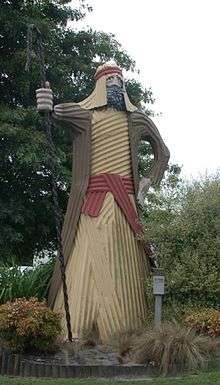
The town is now a well known tourist stop-off, and is characterised by many art works created out of corrugated iron. The church and many of the shops feature corrugated iron sculptures by local artist Steven Clothier and two large buildings are completely made from this material; the information centre which is shaped like a giant dog,[22] and the neighbouring sheep and ram building[23] - earning Tirau the title of "Corrugated Capital of the World".
The Castle, a large toy museum on the town's southern limits which opened in 2000, can clearly be seen when heading towards the township from Rotorua or Taupo. The Tīrau dairy factory is New Zealand's only producer of lactalbumin, a key ingredient in the production of sports supplements.[24]
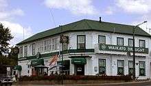 The Tīrau pub |
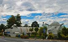 Tīrau's corrugated iron 'giant dog' and 'big sheep' buildings. |
Government
Tīrau is governed locally by the South Waikato District Council. Nationally, Tīrau is part of the Taupō general electorate and the Te Tai Hauāuru Māori electorate.[25]
Education
Tirau Primary School is the sole school in Tīrau. It is a contributing primary school (Years 1–6) and has 120 students as of March 2020.[26]
The nearest secondary school is Putaruru College, 8 kilometres (5 mi) south of Tirau, in Putaruru.
See also
Notes
References
- "2013 Census QuickStats about a place: Tirau". Statistics New Zealand. Retrieved 17 December 2014.
- "1:50,000 map". topomap.co.nz. Topo Map. Retrieved 17 November 2018.
- "Current and historical topographic maps (topomaps) of New Zealand". www.mapspast.org.nz. 1944. Retrieved 13 May 2018.
- "Photo of 1932 Hamilton mystery excursion train at station". NZ ETC. Victoria University of Wellington. Retrieved 17 November 2018.
- Scoble, Juliet (2010). "Names & Opening & Closing Dates of Railway Stations" (PDF). Rail Heritage Trust of New Zealand.
- "1881 Plan of the township of Oxford". www.aucklandcity.govt.nz. Retrieved 13 May 2018.
- "NZGB notices – June 2019". Land Information New Zealand. 21 June 2019. Retrieved 21 April 2020.
- "The New Railway Time-Table". Waikato Times. 6 March 1886. p. 2. Retrieved 15 May 2018.
- "Railway Extension". New Zealand Herald. 23 February 1886. p. 5. Retrieved 15 May 2018.
- "Current and historical topographic maps (topomaps) of New Zealand". www.mapspast.org.nz. 1944. Retrieved 14 May 2018.
- "Appendix to the Journals of the House of Representatives — 1894 Session I — D-01 Page 45". atojs.natlib.govt.nz. Retrieved 14 May 2018.
- "Opening of Railway Line to Lichfield". New Zealand Herald. 15 June 1886. p. 4. Retrieved 15 May 2018.
- "Appendix to the Journals of the House of Representatives — 1894 Session I — D-02 Page 17". atojs.natlib.govt.nz. Retrieved 14 May 2018.
- "Appendix to the Journals of the House of Representatives — 1895 Session I — D-02 Page 25". atojs.natlib.govt.nz. Retrieved 14 May 2018.
- "Appendix to the Journals of the House of Representatives — 1896 Session I — D-02 Page 11". atojs.natlib.govt.nz. Retrieved 14 May 2018.
- Scoble, Juliet (2010). "Names & Opening & Closing Dates of Railway Stations" (PDF). Rail Heritage Trust of New Zealand.
- "Tirau, South Waikato District". natlib.govt.nz. 1 January 1965. Retrieved 15 May 2018.
- "South Waikato District Council". Archived from the original on 10 March 2007. Retrieved 2 April 2006.
- "Local Government Act 2002". Archived from the original on 24 March 2006. Retrieved 2 April 2006.
- "Te Kāhui Māngai directory". tkm.govt.nz. Te Puni Kōkiri.
- "Māori Maps". maorimaps.com. Te Potiki National Trust.
- "The i-SITE Visitor Centre". Retrieved 26 April 2019.
- Wilkie, Kelsie (20 October 2016). "Corrugated iron sheep and ram buildings in Tirau for sale". Stuff.
- "Tirau". Fonterra. Retrieved 27 March 2013.
- "Find my electorate". Electoral Commission. Retrieved 19 December 2015.
- "New Zealand Schools Directory". New Zealand Ministry of Education. Retrieved 26 April 2020.