Tüttensee
The Tüttensee (Lake Tütten) is a small lake in the Bavarian Alpine foothills of the Traunstein district, within the municipalities of Grabenstätt and Vachendorf. With an area of 10.8 ha (~ 27 acres) and a maximum depth of 17.3 m it is one of many Kettle-Lakes in the alpine foothills, that resulted from remnants of dead-ice after a glacier retreated.[2]
| Data[1] | |
| name: | Tüttensee |
| location: | Bavaria, Germany |
| water level: | 523 m above sea level (NN) |
| area: | 10,8 ha |
| maximum depth: | 17,3 m |
| mean depth: | 9,4 m |
| volume: | 1 020 000 m3 |
| perimeter: | 1280 m |
| Catchment area: | 0,8 km2 |
| islands: | none |
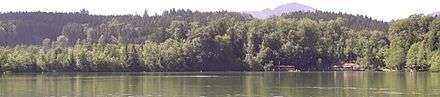
The lake is partly surrounded by well preserved Kame terraces and drains to the north west into the tiny Marwanger Creek to the Chiemsee. At the southern lake shore is a small public beach with an Inn and further amenities.
Recent geological and biological research showed that the Tüttensee has an undisturbed profile of peat bog since the Würm glaciation and over more than 12.500 years since.[3][4]
The recent dating of the undisturbed peak horizons refuted claims by amateur geologists, that the Tüttensee was the result of a hypothetical meteor impact within the last 4000 years.
References
- Wasserwirtschaftsamt Traunstein: Tüttensee
- J. Gareis: Die Toteisfluren des bayerischen Alpenvorlandes als Zeugnis für die Art des spätwürmzeitlichen Eisschwundes, Würzburger Geographische Arbeiten, Würzburg 1978, 101 Pages.
- Bayerisches Landesamt für Umwelt: Neue Altersdaten: Kein "Kelten-Komet" im Chiemgau. Press Release by the Bavarian State Agency for the Environment, 24. August 2010 (German)
- Publication of the supporting data: Ernst Krömer: Sedimententnahme und Datierungen in der Verlandungszone des Tüttensees, 23 August 2010 (partly German, partly English)