Tét
Tét (German: Tietzing) is a town in Győr-Moson-Sopron county, Hungary. It is located between the town of Pápa (21 km north) and the city of Győr (24 km south) in the Little Hungarian Plain. According to 1990 census it used to have 4,252 inhabitants, nearly all of them Hungarian by ethnicity. Neighbouring settlements are: Rábaszentmihály, Kisbabot, Rábaszentmiklós, Mórichida, Gyömöre, Felpéc, Győrszemere and the city of Győr.[2]
Tét | |
|---|---|
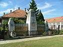 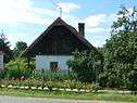   View of Tét, Kisfaludy memorial, Old house in Tétszentkút, Jewish cemetery, Aerial view of the castle | |
 Flag  Coat of arms | |
 Location of Tét | |
| Coordinates: 47.5167°N 17.5167°E | |
| Country | |
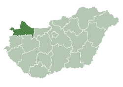
| County | Győr-Moson-Sopron |
| District | Tét |
| Area | |
| • Total | 56.35 km2 (21.76 sq mi) |
| Population (2015)[1] | |
| • Total | 4,020 |
| • Density | 71/km2 (180/sq mi) |
| Time zone | UTC+1 (CET) |
| • Summer (DST) | UTC+2 (CEST) |
| Postal code | 9100 |
| Area code | (+36) 96 |
| Website | www |
History
In 1910 Tét was a village in the Sokoróalja district of the Győr County with 4,111 inhabitants. In terms of religion: 1,935 citizens (47,1%) were Lutheran, 1,890 (46,0%) Roman Catholic, 432 (10,5%) Jewish and 52 (1,3%) others. Tét population grew steadily in the interwar period. Notably, the Jews of Tét were forced into a transit ghetto and than sent aboard Holocaust trains to the Auschwitz concentration camp during the Holocaust. They are featured in the Auschwitz Album, the only surviving pictorial evidence of the extermination process from inside Birkenau.
Tét received town rights (Város) in 2001.[2] Current population is estimated at 4,104 inhabitants.

References
- Gazetteer of Hungary, 1st January 2015. Hungarian Central Statistical Office.
- István Molnár (28 November 2000), Tét. Overview.
External links
| Wikimedia Commons has media related to Tét. |
- Official website in Hungarian
| Town (1) |
| |
|---|---|---|
| Villages (13) | ||