Sycamore, Kansas
Sycamore (also Lay) is an unincorporated community in northern Montgomery County, Kansas, United States. It lies along U.S. Route 75 north of the city of Independence.[1]
Sycamore, Kansas | |
|---|---|
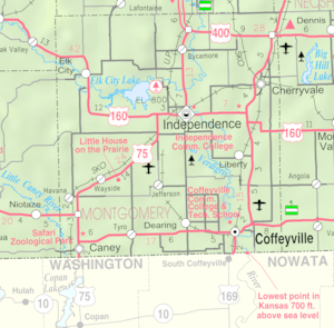 KDOT map of Montgomery County (legend) | |
 Sycamore  Sycamore | |
| Coordinates: 37°19′37″N 95°42′56″W | |
| Country | United States |
| State | Kansas |
| County | Montgomery |
| Time zone | UTC-6 (Central (CST)) |
| • Summer (DST) | UTC-5 (CDT) |
| ZIP codes | 67363 |
History
Sycamore had its start by the building of the railroad through that territory.[2]
The post office, established as Lay in 1887, was renamed Sycamore in 1896.[3] Although it is unincorporated, it has a post office, with the ZIP code of 67363.[4]
Geography
Its elevation is 843 feet (257 m), and it is located at 37°19′37″N 95°42′56″W (37.3270085, -95.7155358).[5]
Climate
The climate in this area is characterized by hot, humid summers and generally mild to cool winters. According to the Köppen Climate Classification system, Sycamore has a humid subtropical climate, abbreviated "Cfa" on climate maps.[6]
References
- Rand McNally. The Road Atlas '08. Chicago: Rand McNally, 2008, p. 41.
- Duncan, L. Wallace (1903). History of Montgomery County, Kansas. Press of Iola Register. pp. 82.
- "Kansas Post Offices, 1828-1961". Kansas Historical Society. Retrieved 16 June 2014.
- Zip Code Lookup
- Geographic Names Information System Feature Detail Report, Geographic Names Information System, 1978-10-13. Accessed 2008-04-12.
- Climate Summary for Sycamore, Kansas
External links
Municipalities and communities of Montgomery County, Kansas, United States | ||
|---|---|---|
| Cities | 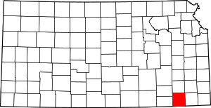 Map of Kansas highlighting Montgomery County | |
| Unincorporated communities | ||
| Ghost towns | ||