Sweetwater, Oklahoma
Sweetwater is a town in Beckham and Roger Mills counties in the U.S. state of Oklahoma. It was incorporated in 1998.[4] As of the 2010 census it had a population of 87.[5]
Sweetwater, Oklahoma | |
|---|---|
Town | |
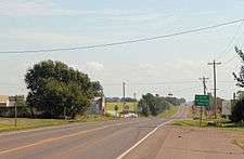 Looking east on Oklahoma State Highway 152 | |
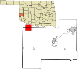 Location in Beckham County and the state of Oklahoma | |
| Coordinates: 35°25′20″N 99°54′41″W | |
| Country | United States |
| State | Oklahoma |
| County | Beckham (also in Roger Mills) |
| Area | |
| • Total | 15.87 sq mi (41.11 km2) |
| • Land | 15.85 sq mi (41.06 km2) |
| • Water | 0.02 sq mi (0.04 km2) |
| Elevation | 2,172 ft (662 m) |
| Population (2010) | |
| • Total | 87 |
| • Estimate (2019)[3] | 83 |
| • Density | 5.30/sq mi (2.05/km2) |
| Time zone | UTC-6 (Central (CST)) |
| • Summer (DST) | UTC-5 (CDT) |
| ZIP codes | 73666 |
| FIPS code | 40-71900 |
History
Named for nearby Sweetwater Creek, the town is at the junction of State Highway 30 and State Highway 152. Sweetwater originated around the time of the Cheyenne-Arapaho land opening in 1892. A post office for Sweetwater was established September 27, 1894 (current zip code 73666). By 1910 the community had an estimated population of 50, two general stores, a dry goods–grocery store, a cotton gin and fuel company. The residents expected the construction of a railroad through the area, but none was built, and this limited further growth. The town did expand to about 100 people around the time of World War I, based on being an agricultural service center for the surrounding township, and the postmaster estimated 150 in the 1930s. However, the population started a decline even before World War II as improved roads and automobile transportation carried business south to Erick or east to Elk City.[6]
On May 5, 2007, a tornado, rated on the Enhanced Fujita Scale (EF scale) as EF3, traveled on a path around 100 to 150 yards (91 to 137 m) wide and 7.5 miles (12.1 km) long. It began about 2.5 miles (4.0 km) south of Sweetwater and ended approximately 5 miles (8 km) north of Sweetwater, following State Highway 30. EF3 wind speeds range from 136 to 165 miles per hour (219 to 266 km/h). It severely damaged several buildings in the town, including the church and high school, and destroyed eight homes.[7][8]
Demographics
| Historical population | |||
|---|---|---|---|
| Census | Pop. | %± | |
| 1990 | 238 | — | |
| 2000 | 226 | −5.0% | |
| 2010 | 87 | −61.5% | |
| Est. 2019 | 83 | [3] | −4.6% |
| U.S. Decennial Census[9] | |||
Education
The Sweetwater Public School District is one of the smallest public school districts in the state of Oklahoma. For the most recent data available, it tied with Boley for the smallest high school with 15 students. For a combined district, K-12, Sweetwater finished third behind Boley (51) and Clarita (58), with 60 students.[10]
References
- "2018 U.S. Gazetteer Files". United States Census Bureau. Retrieved Feb 12, 2020.
- U.S. Geological Survey Geographic Names Information System: Sweetwater, Oklahoma
- "Population and Housing Unit Estimates". Retrieved May 21, 2020.
- "Boundary Changes". Geographic Change Notes: Oklahoma. Population Division, United States Census Bureau. 2006-05-19. Archived from the original on 2010-08-06. Retrieved 2008-07-02.
- "Geographic Identifiers: 2010 Demographic Profile Data (G001): Sweetwater town, Oklahoma". U.S. Census Bureau, American Factfinder. Archived from the original on February 12, 2020. Retrieved February 24, 2014.
- "Sweetwater". Oklahoma Historical Society. Retrieved March 6, 2020.
- May 5, 2007 Sweetwater, Oklahoma Tornado Rated As EF3 at the National Weather Center (NOAA)
- Second wave of tornadoes rakes Plains - CNN
- "Census of Population and Housing". Census.gov. Retrieved June 4, 2015.
- School District Database at the Oklahoma State Department of Education (OSDE) Archived 2007-08-02 at the Wayback Machine
External links
Municipalities and communities of Beckham County, Oklahoma, United States | ||
|---|---|---|
| Cities |  Beckham County map | |
| Towns | ||
| Unincorporated communities | ||
| Footnotes | ‡This populated place also has portions in an adjacent county or counties | |
Municipalities and communities of Roger Mills County, Oklahoma, United States | ||
|---|---|---|
| Towns |  Roger Mills County map | |
| Unincorporated communities | ||
| Footnotes | ‡This populated place also has portions in an adjacent county or counties | |