Svortland
Svortland or Bremnes is the administrative centre of Bømlo municipality in Vestland county, Norway. The village is located in the north-central part of the island of Bømlo, about 6 kilometres (3.7 mi) west of the village of Rubbestadneset. The village surrounds the lake Storavatnet. The Norwegian County Road 542 runs through the village.
Svortland Bremnes | |
|---|---|
Village | |
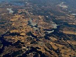 View of the village area | |
 Svortland Location of the village  Svortland Svortland (Norway) | |
| Coordinates: 59°47′34″N 05°10′20″E | |
| Country | Norway |
| Region | Western Norway |
| County | Vestland |
| District | Sunnhordland |
| Municipality | Bømlo |
| Area | |
| • Total | 2.57 km2 (0.99 sq mi) |
| Elevation | 20 m (70 ft) |
| Population (2019)[1] | |
| • Total | 2,932 |
| • Density | 1,141/km2 (2,960/sq mi) |
| Time zone | UTC+01:00 (CET) |
| • Summer (DST) | UTC+02:00 (CEST) |
| Post Code | 5430 Bremnes |
The 2.57-square-kilometre (640-acre) village has a population (2019) of 2,932 and a population density of 1,141 inhabitants per square kilometre (2,960/sq mi).[1] In addition to municipal services, Svortland is also the location of Bremnes Church, an elementary school, a medical centre, a community centre, and many stores and businesses.[3]
The village was historically named Bremnes after the local church. There was also a local farm in Bremnes called Sortland, which was also used to refer to the area. In the 1990s, the municipal council officially named the urban area Svortland.
References
- Statistisk sentralbyrå (1 January 2019). "Urban settlements. Population and area, by municipality".
- "Svortland, Bømlo (Hordaland)" (in Norwegian). yr.no. Retrieved 19 February 2015.
- Store norske leksikon. "Svortland" (in Norwegian). Retrieved 19 February 2015.