Suhum/Kraboa/Coaltar District
The Suhum-Kraboa-Coaltar District is one of the twenty-one (21) districts of the Eastern Region of south Ghana. The capital is Suhum.[1]
Suhum-Kraboa-Coaltar District | |
|---|---|
Seal | |
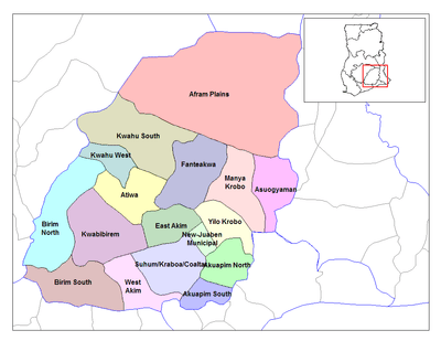 Eastern Region districts | |
 Suhum-Kraboa-Coaltar District Location of Suhum-Kraboa-Coaltar district in Eastern Region | |
| Coordinates: 6.0344°N 0.4524°W | |
| Region | Eastern Region |
| Capital | Suhum |
| Government | |
| • Type | District Assembly |
| • District Executive | Michael Kofi Mensah |
| Area | |
| • Total | 1,018 km2 (393 sq mi) |
| Population (2013) | |
| • Total | — |
| Time zone | UTC+0 (Greenwich Mean Time) |
| • Summer (DST) | GMT |
Geography
Suhum-Kraboa-Coaltar District shares boundaries with East Akim Municipal District to the north, Akuapim South Municipal District to the south, West Akim District and Kwaebibirem District to the west and New Juaben and Akuapim North to the east. The Suhum-Kraboa-Coaltar District covers an area of 1,018 km². The river Densu is the largest water body within the district and flows from the northern part of the district to the south.[1]
List of settlements
The Suhum-Kraboa-Coaltar district is essentially a rural district with only Suhum (the capital) being classified as an urban area.
| Settlements of Suhum-Kraboa-Coaltar District | |||
| No. | Settlement | Population | Population year |
|---|---|---|---|
| 1 | Abenabu No. 2 | ||
| 2 | Akorabo | ||
| 3 | Akyeansa | ||
| 4 | Amanase | ||
| 5 | Anum Apapam | ||
| 6 | Asuboi | ||
| 7 | Brong Densuso | ||
| 8 | Kraboa Coaltar | ||
| 9 | Dokrokyewa | ||
| 10 | Kofi pare | ||
| 11 | Krabokese | ||
| 12 | Kuano | ||
| 13 | Kwaboanta | ||
| 14 | Obuoho | ||
| 15 | Okorase | ||
| 16 | Otoase | ||
| 17 | Sowatey | ||
| 18 | Suhum | 49,398 | 2013 |
| 19 | Teacher Mante | ||
| 20 | Nankese | ||
References
Sources
| Municipal |
| .svg.png) |
|---|---|---|
| District |
| |
This article is issued from Wikipedia. The text is licensed under Creative Commons - Attribution - Sharealike. Additional terms may apply for the media files.