Suchá nad Parnou
Suchá nad Parnou is a village and municipality in the Trnava District in the Trnava region of Slovakia. The municipality is located in the Trnava Upland, partially in the valley of the rivers Podháj and Parná. Suchá nad Parnou has an area of 1468 ha and is situated at an altitude of 161–231 m above sea level, with the center of the village at 174 m above sea level. The village Šelpice lays to the East, to the Southeast and South lay Zvončín and Ružindol, in the east Suchá nad Parnou is bordered by Dlhá. To the North Košolná, Boleráz and on Northwest Klčovany are located. Suchá nad Parnou is situated about 7 km to the west of Trnava.
Suchá nad Parnou | |
|---|---|
Village | |
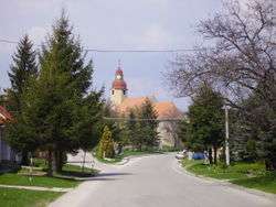 Saint Martin's Church | |
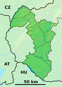 Suchá nad Parnou Location of Suchá nad Parnou in the Trnava Region  Suchá nad Parnou Suchá nad Parnou (Slovakia) | |
| Coordinates: 48°24′35″N 17°29′23″E | |
| Country | Slovakia |
| Region | Trnava |
| District | Trnava |
| Area | |
| • Total | 14.38 km2 (5.55 sq mi) |
| Elevation | 174 m (571 ft) |
| Population (2004-12-31) | |
| • Total | 1,738 |
| • Density | 120/km2 (310/sq mi) |
| Postal code | 919 01 |
| Car plate | TT |
| Website | www.suchanadparnou.sk |
Famous people
- Ján Ježovít (*1909 – † 1994), SDB, Roman Catholic priest end Missionary (China, Thailand).[1]
References
- KUBANOVIČ, Zlatko: Historický náhľad do dejín slovenských saleziánov (Od dona Bosca do roku 1924). Bratislava : Don Bosco, 2019. ISBN 978-80-8074-436-6. S. 248 – 249.
External links
| Wikimedia Commons has media related to Suchá nad Parnou. |
- http://en.e-obce.sk/obec/suchanadparnou/sucha-nad-parnou.html
- http://www.suchanadparnou.sk/ (in Slovak)
| Authority control |
|---|
This article is issued from Wikipedia. The text is licensed under Creative Commons - Attribution - Sharealike. Additional terms may apply for the media files.