Stuttgart-North
Stuttgart-Nord is an inner city district in the north of Stuttgart.
Stuttgart-North Stuttgart-Nord | |
|---|---|
District of Stuttgart | |
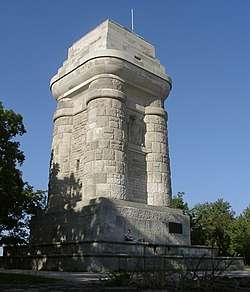 Bismarckturm | |
 Coat of arms | |
Location within Stuttgart 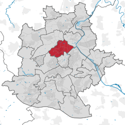 | |
 Stuttgart-North 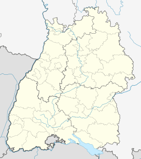 Stuttgart-North | |
| Coordinates: 48°47′50″N 9°10′37″E | |
| Country | Germany |
| State | Baden-Württemberg |
| Admin. region | Stuttgart |
| District | Stuttgart |
| City | Stuttgart |
| Founded | 10th Century |
| Government | |
| • District Chairwoman | Andrea Krueger (CDU) |
| Area | |
| • Total | 6.815 km2 (2.631 sq mi) |
| Highest elevation | 409 m (1,342 ft) |
| Lowest elevation | 210 m (690 ft) |
| Population | |
| • Total | 24,755 |
| • Density | 3,600/km2 (9,400/sq mi) |
| Time zone | CET/CEST (UTC+1/+2) |
| Postal codes | 70174, 70191, 70192 |
| Dialling codes | 0711 |
| Vehicle registration | S |
| Website | www.stuttgart.de |
Geography
Stuttgart-Nord extends from the Doggenburg to the highest point, the Gähkopf (409 m above sea level) to the Bismarckturm, on the Killesberg and the Pragsattel to Rosenstein Park and the Pragfriedhof. The Pragsattel located at the lowest point of a ridge from Killesberg to Burgholzhof.
One finds in Stuttgart-Nord numerous good residential areas and viewpoints on the Stuttgart city center. Noteworthy streets are: Am Bismarckturm, Am Gähkopf, Caesar Flaischlen Street, Eduard-Pfeiffer-Straße, Feuerbacher Heide, Lenzhalde, Robert-Bosch-Straße and Schottstraße.
History
When Stuttgart was divided into districts in 1956, Stuttgart-North was created. The western boundary of this new district extended from the Doggenburg to Weißenhof and Killesberg. When the districts were reorganized January 1, 2001, Stuttgart-North was split itself into 11 subdistricts.
Districts of Stuttgart | ||
|---|---|---|
| Inner districts |
| |
| Outer districts |
| |
| Authority control |
|
|---|