Stryn (village)
Stryn is the administrative centre of Stryn Municipality in Vestland county, Norway. The village is located on the shore of a small bay off of the main Nordfjorden. The mouth of the river Stryneelva is in the village. The village sits about 3.5 kilometres (2.2 mi) west of the village of Nedstryn.[3]
Stryn Tonning | |
|---|---|
Village | |
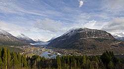 View of the village (looking northeast) | |
 Stryn Location of the village  Stryn Stryn (Norway) | |
| Coordinates: 61°54′09″N 06°43′04″E | |
| Country | Norway |
| Region | Western Norway |
| County | Vestland |
| District | Nordfjord |
| Municipality | Stryn Municipality |
| Area | |
| • Total | 1.92 km2 (0.74 sq mi) |
| Elevation | 5 m (16 ft) |
| Population (2019)[1] | |
| • Total | 2,553 |
| • Density | 1,330/km2 (3,400/sq mi) |
| Time zone | UTC+01:00 (CET) |
| • Summer (DST) | UTC+02:00 (CEST) |
| Post Code | 6783 Stryn |
The 1.92-square-kilometre (470-acre) village has a population (2019) of 2,553 and a population density of 1,330 inhabitants per square kilometre (3,400/sq mi).[1] It is the largest settlement in the municipality and it is home to the municipal administration, a school, and commercial centre. The village sits at the intersection of Norwegian National Road 15 and Norwegian County Road 60, a major crossroads in the Inner Nordfjord region.
References
- Statistisk sentralbyrå (1 January 2019). "Urban settlements. Population and area, by municipality".
- "Stryn" (in Norwegian). yr.no. Retrieved 2013-10-11.
- Store norske leksikon. "Stryn tettsted" (in Norwegian). Retrieved 2013-10-11.
This article is issued from Wikipedia. The text is licensed under Creative Commons - Attribution - Sharealike. Additional terms may apply for the media files.