Strasburg, Colorado
Strasburg is a census-designated place (CDP) in Adams and Arapahoe counties in the U.S. state of Colorado. The population was 2,447 at the 2010 census,[3] up from 1,402 at the 2000 census.[4] The Strasburg Post Office has the ZIP Code 80136.[2]
Strasburg, Colorado | |
|---|---|
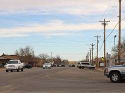 Strasburg, looking east along 15th Avenue. | |
 Location in Arapahoe County and the state of Colorado | |
| Coordinates: 39°44′10″N 104°19′43″W | |
| Country | |
| State | |
| Counties | Adams County[1] Arapahoe County |
| Area | |
| • Total | 20.82 sq mi (53.93 km2) |
| • Land | 20.80 sq mi (53.86 km2) |
| • Water | 0.02 sq mi (0.06 km2) |
| Elevation | 5,381 ft (1,640 m) |
| Population (2010) | |
| • Total | 2,447 |
| • Density | 118/sq mi (45.4/km2) |
| Time zone | UTC-7 (Mountain (MST)) |
| • Summer (DST) | UTC-6 (MDT) |
| ZIP code[2] | 80136 |
| Area code(s) | 303 and 720 |
| FIPS code | 08-74375 |
| GNIS feature ID | 0184999 |
History
A post office called Strasburg has been in operation since 1908.[5] The community was named after John Strasburg, a railroad official.[6]
Geography
Strasburg is located at 39°44′10″N 104°19′43″W (39.736047, -104.328494).[7] According to the United States Census Bureau, the CDP has a total area of 20.82 square miles (53.93 km2), of which 20.80 square miles (53.86 km2) is land and 0.023 square miles (0.06 km2), or 0.12%, is water.[3]
Demographics
| Historical population | |||
|---|---|---|---|
| Census | Pop. | %± | |
| U.S. Decennial Census[8] | |||
At the 2000 census there were 1,402 people, 503 households, and 393 families in the CDP. The population density was 181.1 people per square mile (69.9/km²). There were 532 housing units at an average density of 68.7 per square mile (26.5/km²). The racial makeup of the CDP was 95.44% White, 1.28% African American, 0.57% Native American, 0.21% Asian, 0.07% Pacific Islander, 0.71% from other races, and 1.71% from two or more races. Hispanic or Latino of any race were 2.85%.[4]
Of the 503 households 39.8% had children under the age of 18 living with them, 68.0% were married couples living together, 7.2% had a female householder with no husband present, and 21.7% were non-families. 18.1% of households were one person and 7.6% were one person aged 65 or older. The average household size was 2.76 and the average family size was 3.14.
The age distribution was 29.7% under the age of 18, 5.7% from 18 to 24, 29.2% from 25 to 44, 25.0% from 45 to 64, and 10.4% 65 or older. The median age was 36 years. For every 100 females, there were 100.0 males. For every 100 females age 18 and over, there were 93.7 males.
The median household income was $53,558 and the median family income was $61,157. Males had a median income of $42,097 versus $25,862 for females. The per capita income for the CDP was $19,546. About 3.1% of families and 6.4% of the population were below the poverty line, including 6.7% of those under age 18 and 11.7% of those age 65 or over.
See also
- Colorado census designated places
References
- "US Board on Geographic Names". United States Geological Survey. 2007-10-25. Retrieved 2008-01-31.
- "ZIP Code Lookup" (JavaScript/HTML). United States Postal Service. December 14, 2006. Retrieved December 14, 2006.
- "Geographic Identifiers: 2010 Demographic Profile Data (G001): Strasburg CDP, Colorado". U.S. Census Bureau, American Factfinder. Archived from the original on February 12, 2020. Retrieved May 1, 2013.
- "U.S. Census website". United States Census Bureau. Retrieved 2008-01-31.
- "Post offices". Jim Forte Postal History. Retrieved 11 July 2016.
- Dawson, John Frank. Place names in Colorado: why 700 communities were so named, 150 of Spanish or Indian origin. Denver, CO: The J. Frank Dawson Publishing Co. p. 48.
- "US Gazetteer files: 2010, 2000, and 1990". United States Census Bureau. 2011-02-12. Retrieved 2011-04-23.
- "Census of Population and Housing". Census.gov. Retrieved June 4, 2016.
Municipalities and communities of Adams County, Colorado, United States | ||
|---|---|---|
| Cities | 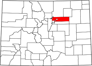 Map of Colorado highlighting Adams County | |
| Towns | ||
| CDPs | ||
| Unincorporated communities | ||
| Footnotes | ‡This populated place also has portions in an adjacent county or counties | |
Municipalities and communities of Arapahoe County, Colorado, United States | ||
|---|---|---|
| Cities |  Map of Colorado highlighting Arapahoe County | |
| Towns | ||
| CDPs | ||
| Footnotes | ‡This populated place also has portions in an adjacent county or counties | |