Stordal (village)
Stordal is the administrative centre of Fjord Municipality in Møre og Romsdal county, Norway. The village is located on the eastern shore of the Storfjorden at the mouth of the river Stordalselva. The village of Sjøholt (in neighboring Ålesund Municipality) lies about 16 kilometres (9.9 mi) north of Stordal, on the other side of the Stordal Tunnel. The historic mountain farm, Ytste Skotet, lies about 6 kilometres (3.7 mi) to the northwest, across the fjord.[3]
Stordal | |
|---|---|
Village | |
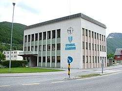 View of the municipal administration building in Stordal village | |
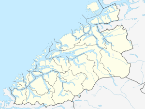 Stordal Location in Møre og Romsdal  Stordal Stordal (Norway) | |
| Coordinates: 62.3820°N 6.9863°E | |
| Country | Norway |
| Region | Western Norway |
| County | Møre og Romsdal |
| District | Sunnmøre |
| Municipality | Fjord Municipality |
| Area | |
| • Total | 0.7 km2 (0.3 sq mi) |
| Elevation | 3 m (10 ft) |
| Population (2018)[1] | |
| • Total | 623 |
| • Density | 890/km2 (2,300/sq mi) |
| Time zone | UTC+01:00 (CET) |
| • Summer (DST) | UTC+02:00 (CEST) |
| Post Code | 6250 Stordal |
The 0.7-square-kilometre (170-acre) village has a population (2018) of 623 and a population density of 890 inhabitants per square kilometre (2,300/sq mi).[1] The main church for the municipality, Stordal Church is located in this village. The Old Stordal Church, now a museum, is also located here.
References
- Statistisk sentralbyrå (1 January 2018). "Urban settlements. Population and area, by municipality".
- "Stordal (Møre og Romsdal)". yr.no. Retrieved 2019-08-18.
- Store norske leksikon. "Stordal – tettstedet" (in Norwegian). Retrieved 2013-06-15.