Stjernøya
Stjernøya (Northern Sami: Stierdná) is an island in western Troms og Finnmark county, Norway. The 248.1-square-kilometre (95.8 sq mi) island sits at the mouth of the Altafjorden on the south side of the Sørøysundet strait. It is divided among the municipalities of Loppa, Hasvik, and Alta. The highest point on the island is the 960-metre (3,150 ft) tall mountain Kjerringfjordfjellet. One of the larger fjords on the island is the Sørfjorden. There were 80 residents on the mountainous island in 2012. The main population area is at the village of Store Kvalfjord on the northeastern side of the island. On the southern part of the island there is a large nepheline syenite mine at Lillebukt.[1] The island is separated from the mainland by the strait of Stjernsundet.[2]
| Native name: Stierdná | |
|---|---|
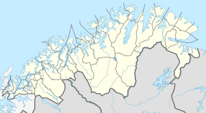 Stjernøya Location of the island  Stjernøya Stjernøya (Norway) | |
| Geography | |
| Location | Troms og Finnmark, Norway |
| Coordinates | 70.31°N 22.66°E |
| Area | 248.1 km2 (95.8 sq mi) |
| Length | 27 km (16.8 mi) |
| Width | 16 km (9.9 mi) |
| Highest elevation | 960 m (3,150 ft) |
| Highest point | Kjerringfjordfjellet |
| Administration | |
Norway | |
| County | Troms og Finnmark |
| Municipalities | Alta, Hasvik, Loppa |
| Demographics | |
| Population | 80 (2012) |
| Pop. density | 0.32/km2 (0.83/sq mi) |
See also
References
- Store norske leksikon. "Stjernøya" (in Norwegian). Retrieved 2018-06-23.
- Evensen, Knut Harald, ed. (2010). NAF Veibok 2010–2012 (in Norwegian) (29 ed.). Oslo: Norges Automobil-Forbund. p. 135.