Steria (creek)
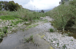
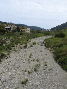
The Steria[1] or Cervo[2] is a 9.6-kilometre (6.0 mi) stream of Liguria (Italy).
| Steria | |
|---|---|
 | |
 | |
| Location | |
| Country | Italy |
| Physical characteristics | |
| Source | |
| • location | Monte Lago (Ligurian Alps) |
| Mouth | Ligurian Sea |
• location | between San Bartolomeo al Mare and Cervo (IM) |
• coordinates | 43.9211°N 8.1073°E |
• elevation | 0 m (0 ft) |
| Length | 9.6 km (6.0 mi)[1] |
| Basin size | 21.97 km2 (8.48 sq mi)[1] |
Geography
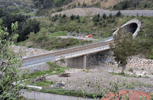
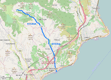
The creek is formed at Monte Lago (Ligurian Prealps, 774 m) in comune of Villa Faraldi, and flows at first heading South-East; near Riva Faraldi it turns South and receives from the left hand Fontana and Paniga creeks.[3] After leaving Villa Faraldi it enters San Bartolomeo al Mare municipality; between Molino del Fico and borgata Freschi gets the waters of its main tributary, torrente di Tovo. The Steria marks then the border between the municipalities of San Bartolomeo al Mare (West) and Cervo following southwards and, after being crossed by Genoa–Ventimiglia railway, Autostrada A10 and Aurelia national road, ends its course in the Ligurian Sea.
Steria basin (22 km2) is totally included in the Province of Imperia.[4] Its valley borders to the West with San Pietro valley, to the North and East with Merula valley.
Main tributaries
- Right hand:
- rio Sorba,
- rio Campanaudo,
- rio Roccafessa,
- rio del Bosco.
- Left hand:
- rio Fontana,
- rio Paniga,
- torrente del Tovo: rises not faraway from Tovo Faraldi and ends in the Steria nearby the village of Freschi,
- rio Gazzelli.
Fishing
The Steria is considered suitable for fishing trouts in its upper course, while going downstream Cyprinidae tend to prevail.[1]
References
- AA.VV. Bacino dello Steria o Cervo (PDF) (in Italian). Provincia di Imperia. Retrieved 2017-04-25.
- AA.VV. (1982). Liguria (in Italian). Touring Editore. p. 474. Retrieved 2017-05-01.
- "Carta tecnica regionale su Limiti Amministrativi (Comunali, Provinciali, Regionali) sc. 1:25000". geoportale.regione.liguria.it. Regione Liguria. 2011.
- 1:25.000 map of the Istituto Geografico Militare, on-line on www.pcn.minambiente.it/viewer