Stemwede
Stemwede is a municipality in the Minden-Lübbecke district, in North Rhine-Westphalia, Germany. Following a recent regional reorganization, in 1973, the former districts of Dielingen-Wehdem and Levern were consolidated and the district of "Stemwede" created. The new name was chosen because for a thousand years the area along the Stemweder Berg (mountain) was popularly referred to as Stemwede.[2]
Stemwede | |
|---|---|
 Coat of arms | |
Location of Stemwede within Minden-Lübbecke district 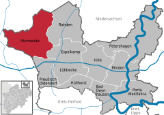  | |
 Stemwede 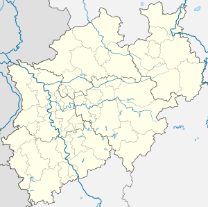 Stemwede | |
| Coordinates: 52°25′N 8°26′E | |
| Country | Germany |
| State | North Rhine-Westphalia |
| Admin. region | Detmold |
| District | Minden-Lübbecke |
| Subdivisions | 3 |
| Government | |
| • Mayor | Ekkehardt Stauß (CDU) |
| Area | |
| • Total | 165.29 km2 (63.82 sq mi) |
| Elevation | 41 m (135 ft) |
| Population (2018-12-31)[1] | |
| • Total | 13,111 |
| • Density | 79/km2 (210/sq mi) |
| Time zone | CET/CEST (UTC+1/+2) |
| Postal codes | 32351 |
| Dialling codes | 05474, 05773, 05745 |
| Vehicle registration | MI |
| Website | www.stemwede.de |
Geography
Stemwede is situated approximately 20 km north-west of Lübbecke.
Division of the town
The municipality of Stemwede is divided into 3 districts (consisting of the following villages each):
|
|
|
References
- "Bevölkerung der Gemeinden Nordrhein-Westfalens am 31. Dezember 2018" (in German). Landesbetrieb Information und Technik NRW. Retrieved 10 July 2019.
- Stemwede Emigrant Database
External links
- Official website

Towns and municipalities in Minden-Lübbecke | ||
|---|---|---|
Coat of Arms of Minden-Lübbecke district | ||
| Authority control |
|
|---|
This article is issued from Wikipedia. The text is licensed under Creative Commons - Attribution - Sharealike. Additional terms may apply for the media files.