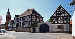
Steinweiler
Steinweiler is a municipality in the district of Germersheim, in Rhineland-Palatinate, Germany.
Steinweiler | |
|---|---|
 | |
 Coat of arms | |
Location of Steinweiler within Germersheim district 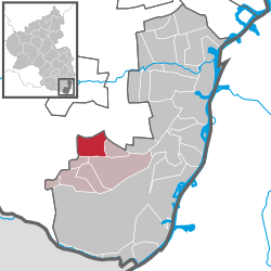 | |
 Steinweiler  Steinweiler | |
| Coordinates: 49°07′15″N 08°08′29″E | |
| Country | Germany |
| State | Rhineland-Palatinate |
| District | Germersheim |
| Municipal assoc. | Kandel |
| Government | |
| • Mayor | Michael Detzel (CDU) |
| Area | |
| • Total | 11.88 km2 (4.59 sq mi) |
| Elevation | 129 m (423 ft) |
| Population (2018-12-31)[1] | |
| • Total | 1,957 |
| • Density | 160/km2 (430/sq mi) |
| Time zone | CET/CEST (UTC+1/+2) |
| Postal codes | 76872 |
| Dialling codes | 06349 |
| Vehicle registration | GER |
| Website | www.steinweiler.eu |
History
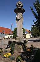
Napoleon's Column
Steinweiler was first created in 968 and was officially given the name "Steinweiler" in 1585.[2] The oldest house in the village dates back to 1724; some others were built in the 1780s and 1790s. There is a column called the "Napoleon's Column" which was erected because Napoleon is said to have walked through this area.
Economy
Steinweiler is surrounded by farms that grow mainly wheat, barley, and corn. It is close to the wine growing region of Germany and hosts a wine festival every year. There is a pig farm in the area. There are just over 1900 people living in Steinweiler.
Tourism
The Black Forest and Alsace are near by.
References
- "Bevölkerungsstand 2018 - Gemeindeebene". Statistisches Landesamt Rheinland-Pfalz (in German). 2019.
- "Archived copy". Archived from the original on 2015-07-22. Retrieved 2015-07-18.CS1 maint: archived copy as title (link)
| Authority control |
|
|---|
This article is issued from Wikipedia. The text is licensed under Creative Commons - Attribution - Sharealike. Additional terms may apply for the media files.